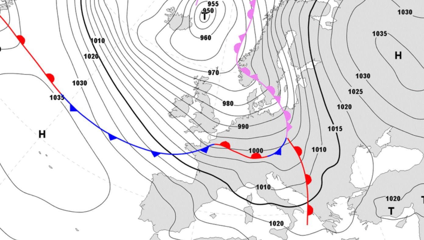
A new storm has popped up on the maps. The Alps will be in the path of a new storm from Tuesday. An active depression moves via the British Isles towards Scandinavia. A strong western current is starting between this depression and a high pressure area above the Atlantic Ocean and this current will bring snow to the west and north of the Alps. This active front is expected in the Alps by Tuesday. You can get ready for PowderAlert #11. In this forecast:
- Sunny weekend
- PowderAlert #10 is still ON
- New storm on its way to the Alps
- PowderAlert #11 from Tuesday/Wednesday
Sunny weekend
Saturday was and Sunday will be mostly sunny in the Alps. A high-pressure area above the Baltic states keeps storm depressions at a distance and an eastern current brings cold air to the Alps. Some incoming clouds cause poor visibility only in the far east of Austria, the southern French Alps and the Piedmont. A lot of snow came down on the southern side of the main alpine ridge at the beginning of this week, which is still loose and powdery. There is room for the sun until Monday and you don’t have to expect fresh snow until then.
PowderAlert #10 is still ON
Although the last snow already came down a few days ago, there is still plenty of untracked snow to find. Especially in the small family ski areas there is still something to find. The new snow could quickly set itself, because huge amounts of snow came down last week in a short time. The avalanche situation has improved considerably in many areas and it’s not as critical as it was in the first days after the snowfall. That means that you can ride more lines, but always read the local avalanche forecast and adapt your plans to it!
PowderAlert # 10 is still in effect and I already published a list with tips about a week ago. That list is still going strong and can be found here. Take advantage of it, because PowderAlert #11 is coming up, but this alert comes with a lot of wind.
wePowder Pro members: thanks for your support!!
We have introduced wePowder Pro this winter. You’ll get extra weather and terrain data for € 25,08 per year (you can not even buy a day pass for that amount in many places). This allows us to further expand our service and we have found a way to express your support to us. Many of the readers of wePowder have done that already and the whole wePowder team and myself are grateful for that. This allows us to keep on developing to make our service even better. Thank you very much!
Are you not a wePowder Pro yet, but do you regularly read the weather forecast or use the services on wePowder? With an upgrade to wePowder Pro you support us, you can express your gratitude and you’ll ride more powder. And it works great for your karma as well. Thanks! Oh, and you’ll get a free 7-day trial when you register yourself on wePowder. No strings attached!
New storm on its way to the Alps
A new storm is heading for the Alps. An active depression starts a western current with lots of wind and snow from Monday evening. First of all, the Alps still have to deal with a rising snow line because the wind temporarily turns to the south a bit it and it warms up during the passage of the warm front on Tuesday, but the cold front soon follows with a rapidly falling snow line and snow to deep into the valleys on Wednesday. In addition, the wind is pretty strong. Cold and warm fronts will alternate even later in the week. The Alps are in the line of fire of the jet stream, and as a result the wind will get stronger. The timing of the fronts is still difficult because of that strong jetstream. For the time being I think that PowderAlert #11 will only bring cold powder (and tree runs) from Wednesday. This will be the rhythm of the storm right now (but obviously this can change).
- Incoming front with lots of snow on Monday evening
- Incoming warm front and a rising snow line (between 1200 and 1800 meter) and lots of wind on Tuesday
- Much colder thanks to an incoming cold front and snowfall deep into the valleys on Wednesday
- Turbulent weather on Thursday, lots of wind and a rising snow line
- Colder on Friday and snow deep into the valleys
You can expect a lot of snow in the western and northern Alps, but you don’t have to expect precipitation south of the main alpine ridge.
PowderAlert #11 from Tuesday/Wednesday
I’d go for Wednesday and Friday for the best powder. More details tomorrow!
Stay stoked,
Morris
Replies
Thanks for the update! i’m heading to Avoriaz next weekend and hoping that the snow line remains low after Friday!
I am booked to ~Bergamo tomorrow night. Have 3 days to ride. Checked forecast in all areas from Alagna to Sestriere - looks like hurricane is coming :-) and lifts won’t work.
Do you have any secret windless spots? #despared
I’ll spend two days in Andermatt (Thursday and Friday).
I’m looking for an alternative spot to have tree runs on the storm of Thursday.
Thx
@@AlexEdwards long term is looking good at the moment
@@jacek, Prali, Bardonecchia (good treeruns), but you can also move North and go to Engelberg on Wednesday and Thursday
@@Fuschetto, maybe Airolo wil get some. Although there is a chance that there might be some sun on Thursday in Andermatt.