Tuesday was a good powder day. The sun came out and because of the fresh snow and the wonderful weather, a number of powder chasers decided to extend the weekend. And for a reason. The powder was still cold in the morning and the sky was blue. A wonderful day in March.
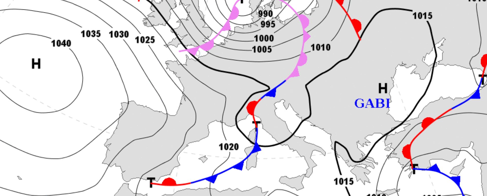
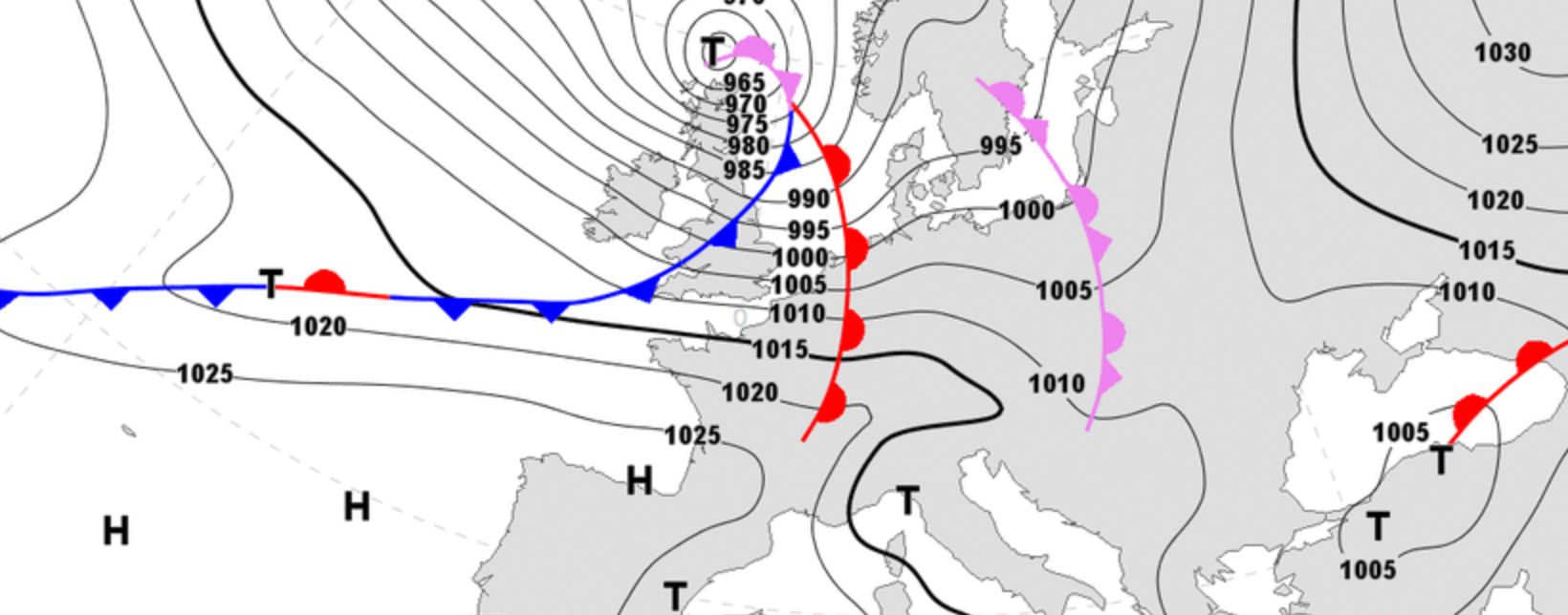
In the meantime, a new front appeared in the west towards the end of the day. The wind turned a little to the southwest, it became milder and higher clouds appeared. Storm Franz is on its way to Europe and the result is once again a lot of snow for the northwestern Alps. The first front will pass this night.
Wednesday is a powder day in…
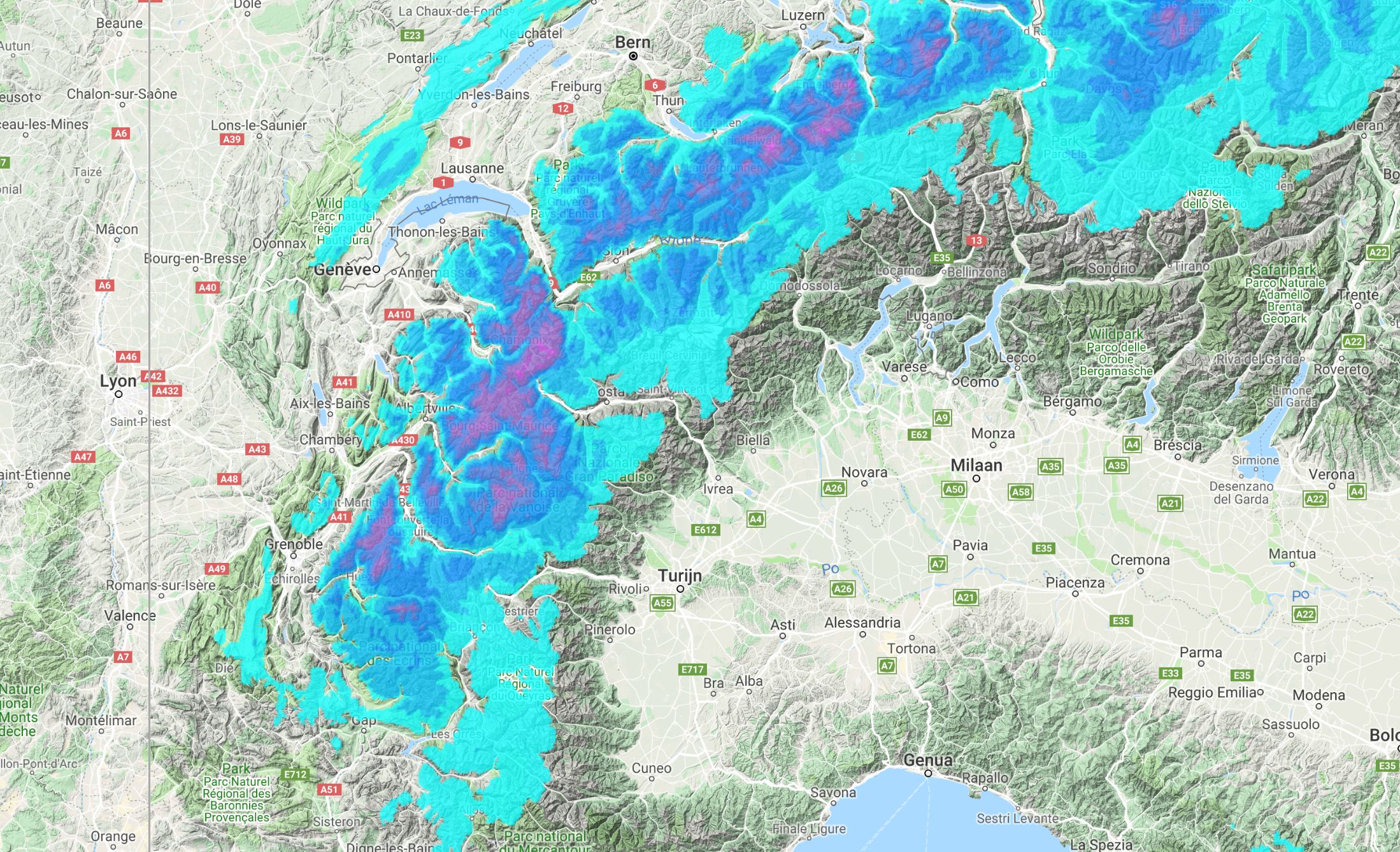
The most snow will come down around Mont Blanc and the Dents du Midi up to and including tomorrow morning (that’s on the border of Switzerland and France). The extreme west of Wallis, just like the northeast of the Haute Savoie can expect the most snow. In addition, I expect 15-30, locally maybe even 35 cm of fresh snow. In addition, the resorts in the Swiss northern alpine ridge can expect 10-20 cm. Just enough to fill in the old traces and turn Wednesday into a powder day in:
- Haute Savoie
- Northwest and the west of Valais
- Canton of Bern
- Central Switzerland
Because the front has largely passed on Wednesday morning, there is also room for sun during the day. But the duration, the location and the intensity are always difficult to predict with the passage of such a cold front. But expect cold powder and maybe even some sun.
Treeruns on Thursday afternoon in…
It won’t be long, because the second front follows in the course of Wednesday and brings a lot of snow until Thursday. Especially Thursday afternoon. The snow line is again low (900-1200 meters) in the west and around 600-900 meters in the east. A significant amount of snow will fall, as in a thick layer of snow in the northwestern Alps. Below the expected snowfall on Thursday.
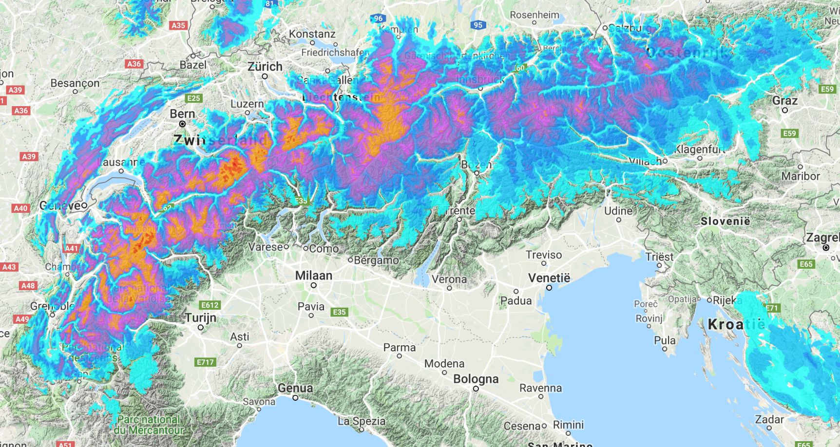
Thursday morning and certainly Thursday afternoon you can ride treeruns in:
- Northwest and west Savoie
- Haute Savoie
- Northwest and the west of Valais
- Canton of Bern
- Central Switzerland
- Eastern Switzerland
- North Graubünden
- Vorarlberg
Thursday is going to be deep and we will ride good treeruns in mid-March. But then the mild Friday.
Rapidly rising snow line on Friday and high avalanche danger
A warm front follows on Friday. The temperature rises again, just like the snow line. You won’t really notice this in the inneralpine valleys because the air in the valleys is still cold here. But because the warm front is pretty persistent and it’s impossible for cold air to reach the Alps due to a high pressure area, it will be milder from Friday.
Expect that Friday starts with rain up to 1000-1500 meters in the Alps in France and Switzerland. At the same time it snows deep into the valleys in the inneralpine valleys of France and Switzerland. We also see the same scenario with 4 to 8 hours delay in Austria. The snow line may still rise towards the 1700 meters and it will only freeze above 2000+ meters later in the day. This will result in an interesting avalanche situation. More about that tomorrow.
It is the prelude to a sunny but mild weekend. Forget the treeruns this weekend. On Saturday and Sunday you want to ride powder in the higher parts of the Alps as it looks right now. The sun comes out and it becomes great riding powder on northern slopes in the areas mentioned above. More details tomorrow.
Long term: mild again?
Still very far away, but more and more models assume that it will stay mild after the weekend. Especially since the last runs aren’t that positive. A front moves into the Alps on Monday / Tuesday. The supply direction and snow line still uncertain. That’s why … if you have time, enjoy the fresh snow now. Thursday in particular is going to be DEEP. We will see what will happen, but this is on the menu for this week:
- Wednesday and especially Thursday: treeruns in the northwest
- Friday and the weekend: late winter conditions, so go for the high alpine. Choose an area in the northwest and north of the Alps with substantial terrain above the tree line.
:nopro:
As wePowder Pro you get access to exposition, freeride routes, slope angle maps and the 14-day forecast per resorts (we’ve got all the resorts in the Alps covered). You never have to miss a dump anymore. When you are wePowder Pro you also have access to 1000+ inspirational freeride routes in the most beautiful freeride areas of the Alps. Sign up as wePowder Pro today. It works great for your karma as well and you’ll support the development of the wePowder platform! Thanks!
:nopro:
Stay stoked,
Morris
Replies
Hi Morris, can be Livigno, or around it, a good choice for saturday? Thanks
Hi Morris. I really love your tips and analysis but you never mention the effects of the wind.
It seems it will be very strong wind from the north, so high alpine faces looking north will be probably hit by the wind.
What do you think?
Hi, should be friday a good powder day in sankt christoph, Austria, right?
Avalanche alert rises on saturday or starting from friday?
@@Trabateo better go up North if you want to enjoy significant powder.
@@mirkotambascia I love to refer to the local avalanche bulletins which go more into detail concerning the wind. The next 72 hours the wind will be strong to gale force from time to time coming in from northwest tot southwest. So eastern and southern aspects will be loaded.
@@Trevisanicolo95 there is significant snow in the forecast from late Thursday afternoon until Friday evening. It will be getting milder so the snow levels will go up. This new denser and heavier snow will be deposited on colder and lighter snow. So I do expect that the avalanche danger will already become critical on Friday during the day.
Hi Morris,
looking for some pow next days. I’m open to drive to Schnalstal or Tyrol tomorrow in order to ski friday or saturday. What do you think will be the best?
Thanks for the great job!!
@@meteomorris
Thank you, I would like it but I can’t :(
I hope to find just a bit good condition (30cm will be right) over the 2000mt in Livigno
Thanks a lot for your wonderful job
Hi Morris, thanks for the info.
Here, at the boundary btw. Italy and Austria it seems not so bad. They forecast a freezing level around 1500m.
http://weather.provinz.bz.it/mountain-weather.asp
I have a question for you: the Bolzano official weather speak about a cold front with moderate snow during the night of sunday to monday up to 1000m.
Do you see the same?
@@Matteo_DG yes… Update will be live during the day.
Last runs are in favor of cold air moving.