
What colours! Finally it’s happening again on a large scale in the Alps, so time for PA#10! Fast forward to the details!
Already snow with a fairly high snowline
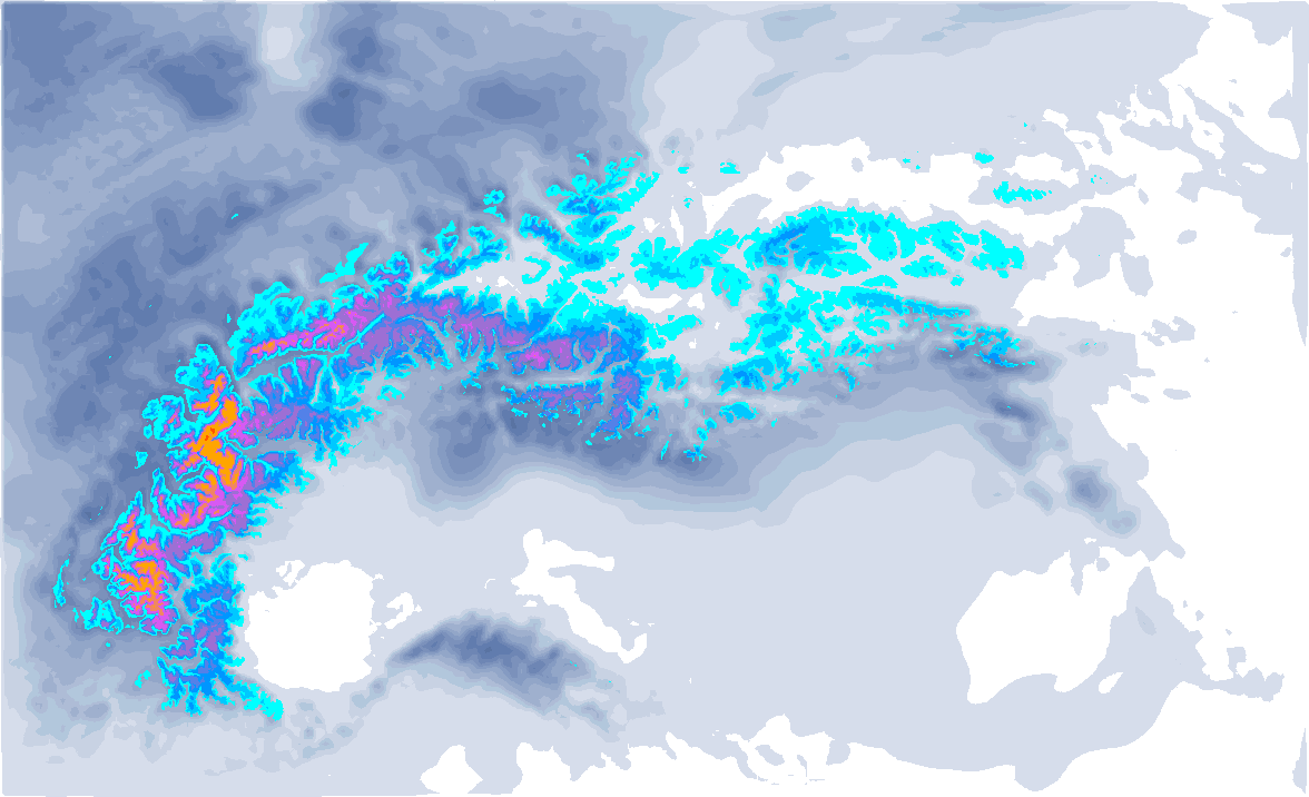
It’s bitter for the French Alps, as the snowline was around 1800 - 2000 metres in many regions during the day on Thursday, especially of course in the Prealpes. There, most of the precipitation fell in the warm sector ahead of the cold front. Inneralpine regions saw the snowline lower for a bit longer, but here too there were some fluctuations in it during the day. So the large amounts of up to half a metre of snow (including the snow that follows) only fell higher up in parts of Haute-Savoie, Savoie and the Valais. In the coming hours, the cold front follows here, causing the snowline to drop rapidly to even below 1,000 metres.
At the same time, it was predominantly dry in the northern Alps with a strong southern föhn on Thursday. Higher up we saw with wind gusts of up to 100 - 120 kilometres per hour. But now to the important stuff: the fresh snow that is coming and is already falling. In the Western Alps, the cold front is thus approaching and also the stau in the Southern Alps is increasing in the coming hours.

Lots of snow for western and southern Alps, but also Austria
So, serious amounts have already fallen in the French Northern Alps and Valais, but only at higher altitudes and also with a lot of wind. L’Ecreuleuse near Les Marecottes at 2252 metres altitude caught almost half a metre. On the mountains north of the Rhone Valley on the border between the Bernese Oberland and Wallis, over 30 centimetres also fell above 2200 - 2500 metres. From these altitudes, this was accompanied by wind gusts of around 70 to 100 kilometres per hour, so count on tricky conditions, also in the French Northern Alps.
With the cold front, some more snow will fall for the entire Western Alps. I expect 5 to 15 centimetres more, higher up 20 centimetres. Strong to stormy winds should also be counted on here during the passage of the cold front.

Then on to the southern side. With a Genoa low, very moist air will be pushed against the southern Alps from now on and squeezed out like a sponge. The areas in and around Lombardy, for example, will receive a thick layer of snow. Think of areas like Madesimo and Adamello, but also the southern areas of Engadin around the Bernina massif, Ticino and the border areas in Wallis. The biggest accumulations here, as more often, are for the Alpi Orobie. Above 1,500 metres, 50 to 70 centimetres of snow could fall until Saturday morning, with most of it falling until Friday afternoon. From then on, it may already clear slightly here. In the other areas, I expect 30 to 50 centimetres of snow. Snow is still falling to fairly high altitude now (1400 - 1800 metres estimated), but Friday it will fall above 1000 - 1200 metres, sometimes even slightly lower.

Further east, a lot of snow is also going to fall, as the strongest intensities of the snowfall shift eastwards Friday during the day. The snowfall also jumps over to the Austrian Northern Alps. General rule of thumb here: the further north, the less snow will fall.
The hotspots are Osttirol, western Carinthia and the alpine main ridge between the Stubai Alps and the Tauern. Here, 30 to 60 centimetres of snow could fall, with a focus around Osttirol and western Carinthia. The Julian Alps could also see a huge amounts of snow, locally 80 centimetres to maybe a metre, but here the snowline could still be quite high overnight. You’ll need some nowcasting tomorrow to know whether conditions will be good enough here.
In South Tyrol and the Dolomites I do expect less, but still around 20 to locally up to 40 centimetres. Note that in all the above-mentioned areas it can be difficult to find a good base below the tree line, especially on the southern faced slopes.
The snowline will be between 1000 and 1200 metres in most parts of the southern Alps, in the extreme south-eastern Alps also temporarily 1400 metres. During heavy snowfall in the stau regions possibly just below 1000 metres as well. On the Austrian north side, the snowline is around 800 to 1000 metres, temporarily also possible down to the lowest valleys.
Wind influence remains generally limited in the Eastern Alps. At the beginning of the snowfall, the upper-level flow in the eastern areas (east of the Dolomites, Osttirol, Salzburgerland) is still quite strong, during the day wind speeds are quite low.
Quieter weekend
Saturday looks set to be a fine day, but it will not stay dry everywhere. The northern Alps will already see (broader) clearings with only occasional snow showers. Also in the Western Alps, it remains partly cloudy with occasional snow still possible, but also some sunshine in between. In the southern Alps, a weak southern flow will create some orographic lift, so it will hardly clear up here and may continue to snow lightly above 1,000 metres.
On Sunday, we will again see this pattern. Supported by the southern föhn, it clears up again in the northern Alps, but also gets a bit warmer. In the southern Alps, there are still some remnants of snowfall, but it won’t give more than a couple of centimetres extra. In the Western Alps, it remains dry, but thick (high) clouds ensure that the sun gets little chance. Another weather change is approaching…

- 1cm
- 5cm
- 10cm
- 15cm
- 20cm
- 30cm
- 40cm
- 50cm
- 75cm
- 100+
- 1mm
- 5mm
- 10mm
- 20mm
- 30mm
- 60mm
- 120+
After that?
After that, the Alps remain under the influence of the low-pressure complex. On Sunday, a new depression approaches from the west, which seems to become quite substantial with a core pressure of around 980 hPa off the coast of Brittany. How will this one affect the Alps?
On Sunday afternoon, it will start snowing from the southwest. This snow will spread over the entire western Alps in the evening, including the Italian side (Piedmont). In the northern Alps, the föhn flow increases and it remains dry. Winds increase again here, especially higher up.
After that, the core pushes its way between the Pyrenees and the French Alps towards the Mediterranean, with another Genoa Low and possibly lots of snow in the southern Alps. This time, the western areas (in Piedmont and Aosta) also seem to benefit more. Warning: the whole weather situation is still a bit tricky to forecast, which means that details are still uncertain. Small (and even larger) changes are possible, so the areas with the strongest snowfall can still move with ease. In our forecast above, for instance, you can also see more snow expected further east.

These regions, Piedmont, Aosta, the French Southern Alps and Lombardy could get a proper snow dump through Tuesday. Half a metre seems possible, more is not even out of the question, but as mentioned: changes are really still possible! Blinding yourself to the main runs (green line above) of the weather models could end up causing disappointments, as the ensemble above shows. The spread is still fairly large.
Réactions
Please bring an update on Saturday