
It’s the second snow dump within a week in the southern Alps. We will see sustained snowfall through Wednesday, but with a rising snowline. It also gets warmer quickly after that, which doesn’t make it easier for the powder search. Due to mediocre internet on the road, it will be a more concise weather update, but hopefully with the most important details.
A brief overview
Brief synoptic overview: a strong low-pressure area over France is currently following a course towards the Alps. In the process, moist air is being pushed against the Alps, which of course results in a nice fresh layer of snow. Last night, snow started to fall in the French Alps and the snowfall also spread to the Italian side rather quickly. In the coming hours/days, the south-western Alps will benefit fully with a retour d’Est due to the formation of a Genoa Low. What does this mean? First check out the background article on the retour d’Est.

First France, now Italy
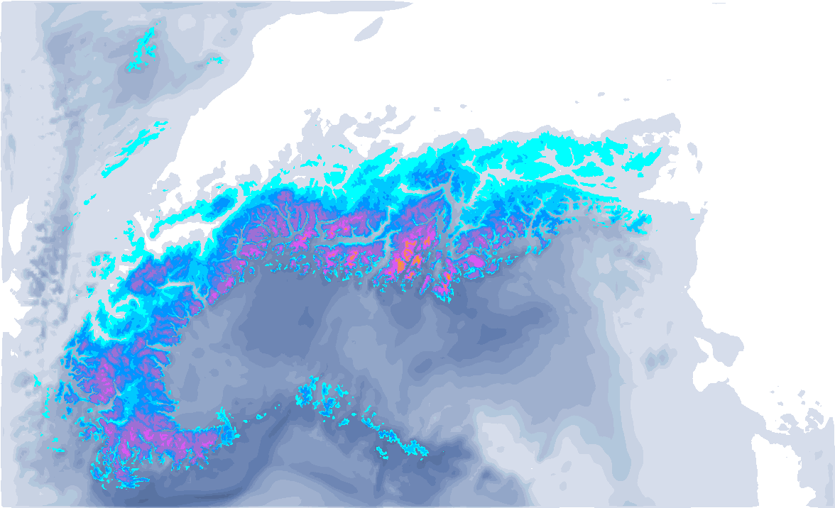
Most of this snow in France has already fallen. According to forecasts on Sunday evening, 20 to locally 30 centimetres south of the Grenoble - Maurienne Valley line at a snowline of around 1,000 to 1,200 metres would be possible, and most nivoses indicate around 20 centimetres fresh. Especially in the southern areas, some additional snow is also falling today, but meanwhile the snowfall is moving to Italy, in the western half to be precise.
The snow will fall at a snowline of around 1,000 to 1,200 metres, sometimes even significantly lower today, but also slightly higher on Tuesday. Large accumulations will be seen in the Alpes-Maritimes/Alpi Marittime in areas such as Prato Nevoso and Limone. Over a metre of snow could fall here, but an important detail to know is that the season so far has been very moderate with (almost) no base to quite high altitudes. This is also true in many other areas in Piedmont. Furthermore, the Italian Alps from from Piedmont to the southern Dolomites can expect well over 50 centimetres of snow until Tuesday evening, in some stau areas also considerably more, further north towards the Alpine main ridge less. For the Dolomites, it will snow solidly especially on Tuesday. Wednesday may see another bucket of snow in the areas, but with a side note.


Rising snowline
The biggest but with this PA is the rising snowline in the southern Alps on Wednesday, as the cold air in the Po Valley is gnawed by the supply of warmer (but therefore moist) air masses during the snowfall. Precipitation cooling will allow narrow, deep, inner-alpine valleys to see a snowline to quite low for longer, but it seems inevitable that Wednesday’s snowline will creep up further. For now, I am assuming a snowline that could rise to 1,800 metres in many places during the day on Wednesday. Locally, as much as another 20 to maybe 50 centimetres of snow could fall above 2000 metres, which could make for seriously large total accumulations.

- 1cm
- 5cm
- 10cm
- 15cm
- 20cm
- 30cm
- 40cm
- 50cm
- 75cm
- 100+
- 1mm
- 5mm
- 10mm
- 20mm
- 30mm
- 60mm
- 120+
So for powder, you will have to keep looking higher up, which could be especially tricky on Wednesday during the snowfall. In the areas close to the southern alpine edge, you will be in the wrong place, because there the snowline already rises faster in the night from Tuesday to Wednesday.
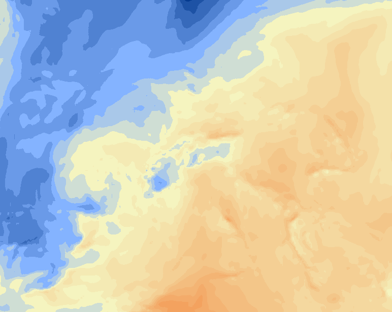
On Thursday it clears up in large parts of the southern Alps, but in the retour d’Est areas of Piemonte it could snow a bit longer in the morning. With temperatures of around 5 degrees at 1500 metres, it will be quite warm all over the southern Alps right away, see also in the maps below.
- -20°
- -15°
- -10°
- -5°
- 0°
- 5°
- 10°
- 15°
- 20°
In the following days it is likely to remain changeable with snow again for the southern Alps. A third dump seems possible, but not yet certain.
Réactions
Another thing to consider: a serious portion of Saharan Dust is approaching on Wednesday, mainly affecting the southern side of the Alps.

Oh Dear, anyone remember March 2022? All sand and no snow? I actually canceled a skitrip back then and went mountainbiking instead. Keep your fingers crossed for more snow and less sand.
March can be powdery paradise 🤞you never know what weather can bring