
- 1cm
- 5cm
- 10cm
- 15cm
- 20cm
- 30cm
- 40cm
- 50cm
- 75cm
- 100+
- 1mm
- 5mm
- 10mm
- 20mm
- 30mm
- 60mm
- 120+
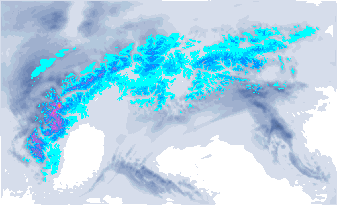
We see yellow and red colours on our snowfall map for the Western Alps, but at the same time it is also getting considerably warmer, so this precipitation is accompanied by a high snowline. Wind also plays a big role. So scoring some powder is not gonna be easy with this snowfall. Because the whole weather situation (just like the avalanche situation for that matter) is quite complex and details can still change (nowcasting is necessary), I decided to wait with PA#8. However, this does not mean that nothing at all is possible.
In this weather report:
- Wednesday high snowline
- Föhn on the northern side
- Thursday evening colder
- Sunny weekend
- No PA, but possibilities

- -20°
- -15°
- -10°
- -5°
- 0°
- 5°
- 10°
- 15°
- 20°
Wednesday high snowline
Around midnight (Tuesday to Wednesday), the first precipitation approached the French northern Alps and western Switzerland. Initially with a snowline of around 1500 metres, but due to the entry of warmer air, it rises rapidly. You can also see this clearly in our forecast of the temperature at around 1500 metres above.
Wednesday morning, the combination of wind and high temperatures makes for nasty conditions. Precipitation initially falls in the morning up to 2200 - 2500 metres altitude as rain. Above that, it becomes white-out. In the inner-alpine valleys, it could possibly snow for a few hundred metres lower for longer, but here too the snowline rises. In the afternoon, however, precipitation activity decreases in more and more places and it may even clear up temporarily. In the evening, another wave of precipitation will already follow. In the high mountains of the French Northern Alps and extreme western Valais, 20 to 40 centimetres of snow could fall (well above 2,500 metres). Below that, the rain will thus have a big impact.
Föhn on the northern side
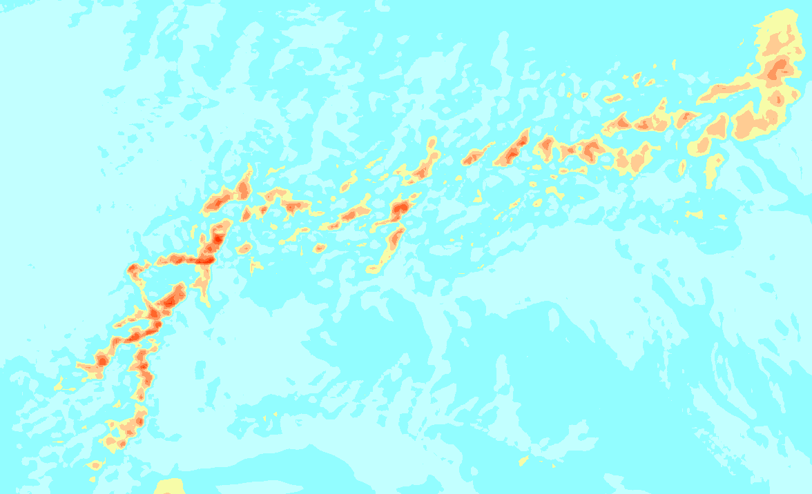
On the northern side of the Alps, a föhn situation will develop simultaneously on Wednesday as the entry of the warm air on the northern side has increased the temperature differences with the southern side (around 1 to -2 degrees at 1500m) considerably. Around the alpine main ridge and the typical föhn valleys, the southern föhn will be felt. As a result, large parts of Austria will also remain pretty much dry. Only at the northern alpine edge, precipitation may fall, which will only fall as snow above 1,500 metres or even higher. At the beginning of this precipitation it may also be temporary some black ice.
In the southern Alps it will also snow, although the significant snow amounts are mainly limited to Lombardy. Around the Adamello and Bernina, some 10 to 20 centimetres could fall. The snowline here will rise from around or below 1,000 metres to around 1,500 metres during Wednesday, although inner-Alpine areas here could also see a surprisingly low snowline for longer.
Snowline falling again
Thursday also starts with a fairly high snowline of around 2,000 metres in the north-western Alps, but cold air moves in from the north-west towards the end of the day, allowing snow to start falling at increasingly lower altitudes. In the Western Alps, the winds increase again significantly during the day in the process, which both the French and Italian areas should take into account. Along the Alpine edge, the wind will also remain strong during the day on Thursday.
In the evening and night into Friday, the snowline will eventually reach the valleys in most places, but the biggest snow amounts will have passed by then, of course.
- 0-2 bft
- 3-5 bft
- 6 bft
- 7 bft
- 8 bft
- 9 bft
- 10 bft
- 11 bft
- 12 bft
In Switzerland, some 10 to 30 centimetres of snow could fall higher up during this falling snowline. Also in the French Northern Alps, these amounts could fall higher up, especially in Haute-Savoie, although these amounts are often still very uncertain in such a situation. Exact amounts at what altitude with this sharp drop in temperature are very hard to predict.

Sunny weekend
The upcoming weekend will be quite cold and sunny. On Saturday in particular, there will be plenty of room for sunshine and it will be nice and cold. Sunday follows from the west with somewhat warmer air also some more (especially high) clouds moving over the Alps.
After that, it seems to get a bit milder again all over the Alps with some precipitation moments. Some snow will still fall regularly from the northwest, but with the higher temperatures I expect a snowline around 1500 metres.

No PA, but possibilities
Although the amounts higher up could actually be enough for a PA, I am not issuing one right now. The snowline is temporarily very high in the areas where most of the snow will fall. On top of that, the strong westerly flow may cause strong winds at the alpine edge as well as by the föhn around the alpine main ridge. The avalanche risk will therefore increase considerably on Wednesday and Thursday. In addition, as mentioned, there are some more uncertainties in the amounts.
However, this of course does not mean that there will be nothing at all in the coming days. Take, for example, the Haute-Durance behind the Écrins around Briançon. In ski resorts like Montgenèvre, although the amounts are lower (here I expect around 30 centimetres), the snowline is also lower. How low exactly is still the question. It depends on how well the cold pools can sustain and how strong the wind will be over there. That will be nowcasting. Precise amounts are also still uncertain here, because during Thursday it also seems to clear up here.
Depending on the wind influence, there could also be some potential in Switzerland. Should the damage from the rain in combination with the wind on Wednesday and Thursday morning not be as bad as expected and the northwestern Stau firm up on Thursday evening, some powder could also be found in the typical stau regions.
Austria (except Vorarlberg and the northern edge) will keep it mostly dry until Thursday afternoon. With the cold north-westerly flow, snow will also follow here in the evening and night into Friday, but more of 5 to 10 centimetres is not in the weather models.
Anyway? If you go out: let here know what the conditions are like with a post and a photo. Not only is it fun to see, but it also helps me verify my weather forecasts during these complex situations.
Reaktionen
Henri, thank you my friend. I get to Geneva Thursday afternoon. How does Zinal sound on Friday to you? It’s nice and high. Would you issue a mini PA for Zinal? :-)

Zinal on Friday
@Henri, do you think it is realistic with a PA based on what has fallen at high altitude, or are the conditions too tricky
We’re in Courmayeur today. Avy risk 4. Lots of wind and the snow is concentrated in pockets. Good stuff between the trees, barren in other places.
We drove through Argentiere this morning. Still snowing and cloudy, but looked promising. Going there tomorrow
We’re in Meribel, snowed down to below 1450. Bottomless powder above 1900-2000.
Excellent!
Very good and deep powder day in Sainte Foy today, even though the powder where a bit on the heavy side.