It’s been Powder Alert after Powder Alert in the last period and once again it’s here. The snowfall in the south-west Alps has started and it is going to s snow heavily again!
Responsible is a decent low pressure area west of France. This depression deepens to around 970 hPa, creating a strong southwesterly high in the Alps. First the bad news: as usual with such a setting, a strong föhn(storm) will follow in the Northern Alps. Here, over the weekend, things could get pretty wild higher up and in the typical north-south oriented valleys. Temperatures will rise, reaching well over 15 degrees in the valleys, and it will also be mild higher up.

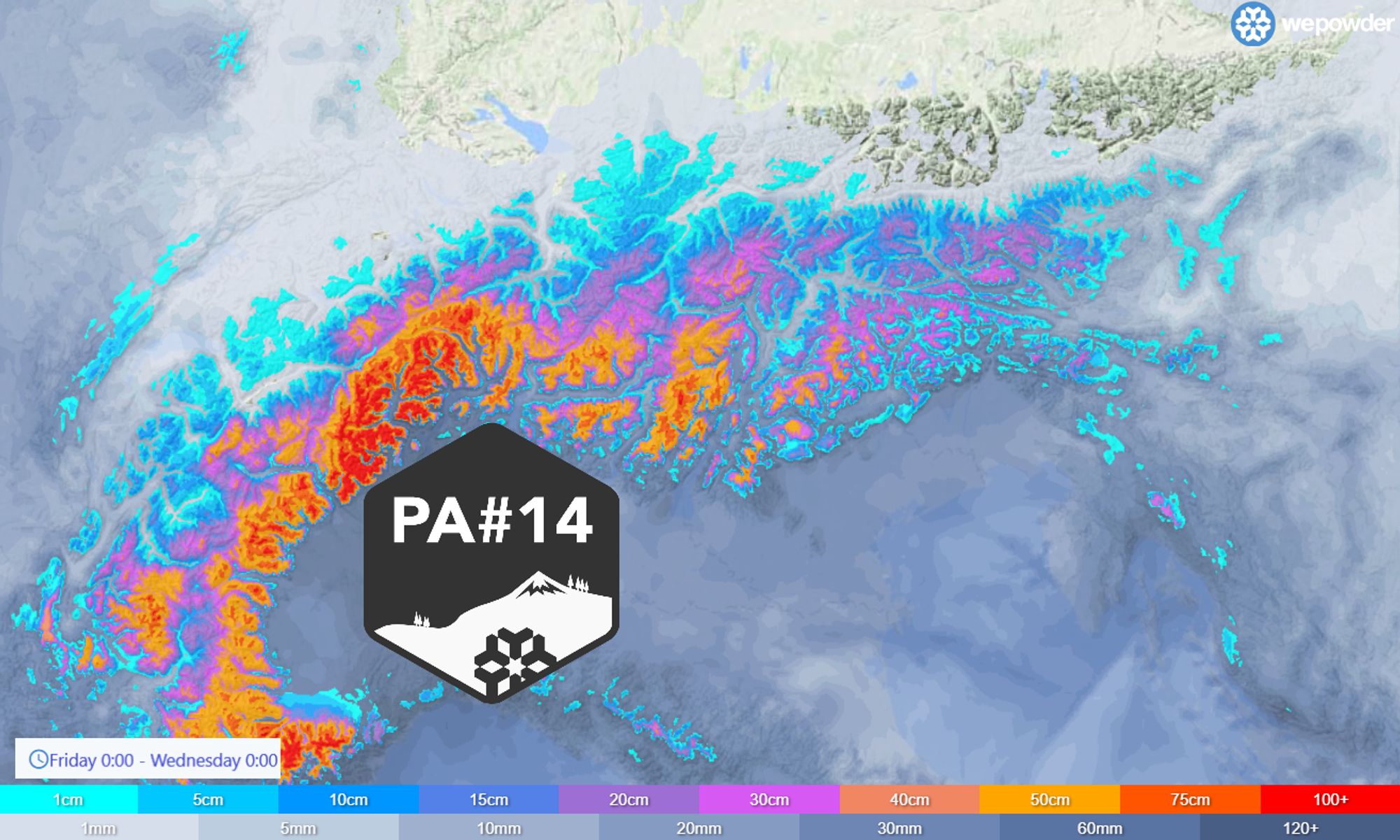
Dump in the Southwestern Alps
The new PowderAlert comes in two waves, of which the second is clearly the strongest. Currently (night from Friday to Saturday), the first wave is underway, with snow in the French South Alps, Piedmont and Ticino. Saturday morning, there will be around 10 to 20 centimetres of snow here in most areas, higher up, some more is also possible. Meanwhile, the snowline will be around 1,000 metres in many places, although of course it will be quite wet snow in the lower few hundred metres as the air is not cold. In the second half of the night, the snowfall also spreads further eastwards towards the Dolomites, but this is no more than a refresher here.

Saturday during the day will be dry in most places in the southern Alps, except for the typical convergence zones (Ticino and Julian Alps), but from the southwest the second and stronger wave will soon follow. It starts snowing heavily in the French southern Alps and Piedmont in the (late) afternoon and evening. Until Sunday morning it dumps further in the south-west Alps, after which the heaviest snowfall shifts rapidly eastwards. In the southern areas of the remaining Italian Alps (e.g. Adamello, South Dolomites), amounts could reach around 30 to 50 centimetres, although locally larger amounts are also possible here. The snowline here is around 1,300 metres, with higher intensities occasionally also lower.

- 1cm
- 5cm
- 10cm
- 15cm
- 20cm
- 30cm
- 40cm
- 50cm
- 75cm
- 100+
- 1mm
- 5mm
- 10mm
- 20mm
- 30mm
- 60mm
- 120+
Back to the hotspots, because this is where buckets of snow are really going to fall. From southern Piedmont to western Ticino on a large scale half a metre, with eastern Aosta, Valsesia to western Ticino catching a metre. Areas like Prali are on the edge of the hotspots and could get around 60-80 centimetres. In the French southern Alps, 40-50 centimetres will also follow on a fairly large scale, in the Alpes-Maritimes (including Isola 2000) significantly more, with also around 80 centimetres. The snowline remains at around 1,200 metres. During intense precipitation, of course, also clearly lower again, but the larger amounts will not fall at those altitudes anyway. Especially in the inner-Alpine areas towards the Alpine main ridge with the Northern Alps, you have to take the stormy winds into account. Otherwise, the wind doesn’t seem to be too bad. Note that this does not mean there’s no wind, especially in the high mountains, where it can still be fairly windy.
Note: In last week’s hotspot, very many areas were closed for several days. Again, this is not out of the question and even likely. Not only because of the rising avalanche risk, but also simply because the ski areas are struggling to cope with the large amounts of snow. Bosco, Macugnaga, Monte Rosa, etc. So check the websites carefully, this will keep you up-to-date. On the edges of the hotspot region, you are more likely to find open lifts.
It will clear from the west on Sunday during the day. First in the French southern Alps, but Piedmont may also see some sunshine by late afternoon. Monday will be a nice day, with an mixture of clouds and sun in the south-western Alps, but with more cloudy conditions in Ticino and east of it. It will remain fairly chilly (but not cold) at first, but from Tuesday onwards it will become considerably milder again.

After the weekend some snow on the northern side
After the weekend, the northern side of the Alps in particular will become a bit more changeable with snow from time to time. It doesn’t seem like it will be much more than 5 to maybe 20 centimetres in the north-western Alps, but at least the snowline seems to be low enough, between 1000 and 1300 metres. The exact distribution is still quite uncertain and some more snow is also not ruled out at this stage. That will have to wait and see for now. In any case, after that it seems to get (a lot) warmer again.
Reaktionen
You guys are getting the goods right now. I see henri, the long range is warm. Is that locked in? Hopefully not! Let me know. Thanks. Heading to france Thursday for 10 days. Hoping for some fresh when there.
@ecsjones it will be warm until next weekend yes, but with large uncertainties from Sunday 17 March on. Some cooling with snow is possible, but that’s still too far away.
thanks @henri. please keep us updated!!! Enjoy the snow today/tmrw. seeing updates for later this week and its like 9 celcius and rain at bases…nervous!!
Henri! Nailed that forecast, LG at the weekend, all the other forecasts for 5-10cm. Your model stuck to the big numbers so we stayed put, wind dropped and we got 50cm+ of cold blower from 3200m and no lift queues all day.