
After a very warm period in the Alps, a strong cooling will now follow. Higher up, the snow cover grows steadily over the next few days. A nice layer of snow will fall until Thursday evening. After a short break on Friday, more snow could follow over the weekend! Time for PA#18!
Two record warm April weekends
I could actually have taken the title of the previous weather report as well, as we are in fact once again emerging from an extraordinary situation in the Alps with two consecutive record-warm weekends. Last weekend we encountered a freezing level reaching peak summer values, record early tropical (30+) temperatures in the valleys and record temperatures of well over 20 degrees at weather stations around 1,500 metres altitude.
Monthly records were pulverised in early and mid-April, whereas they are normally reached in late April (due to higher sunshine levels and more sunshine hours). To take Austria as an example, we now see an anomaly of +6.3 degrees nationwide for the first half of April. The coming cool period will of course bring this way down, but possibly not quite back to normal compared to the 1991-2020 reference period.

It is typical of the overall trend: warm phases are more often very warm to record warm, while cold phases are merely ‘cool’ and not (record) cold. This can also be seen in the ensembles. Whereas we saw anomalies of +12 to +16 degrees during last weekends’ extreme April warmth, the cool phase is ‘only’ -5 to -8 degrees. However, the duration of the upcoming cool period could still make April more or less ‘normal’ in terms of monthly average temperature.

Long-lasting northerly flow
Back to the snow chances. Today (Monday), the Alps were still in front of the strong cold front which passed over Western Europe. With another front, there was already some precipitation, locally even with some thunder, but with a snowline of around 2,500 metres. Next night (Monday to Tuesday) the cooling with the cold front will follow.
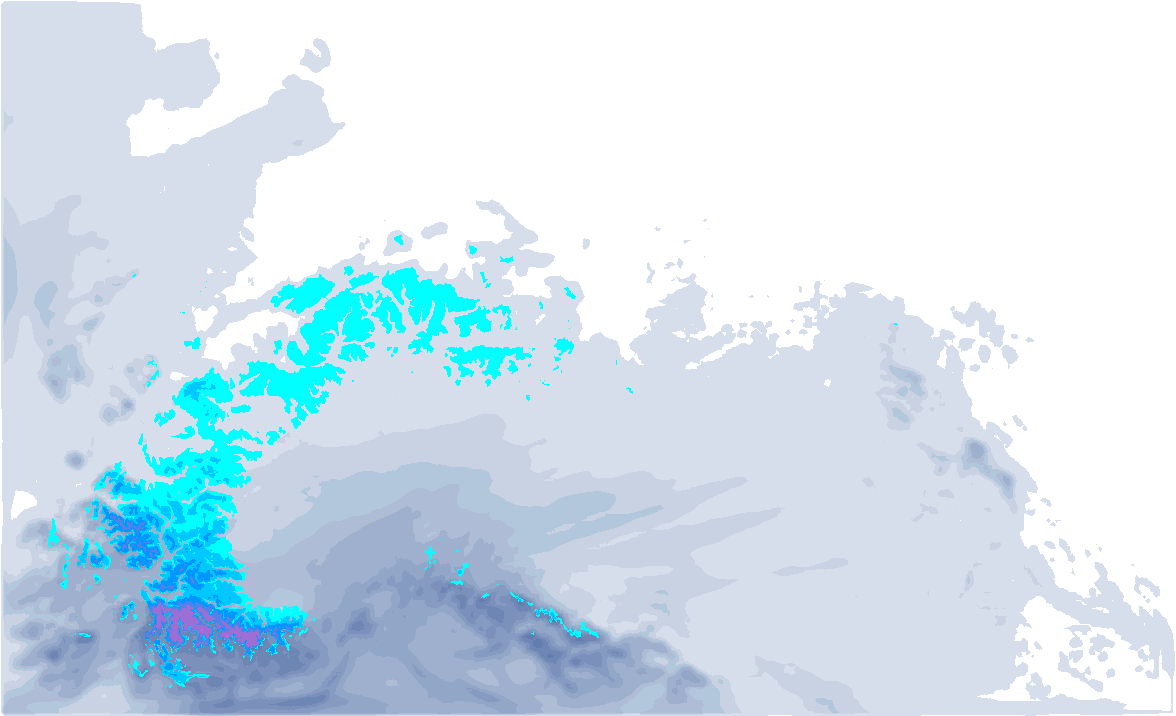
It will not be a fierce dump, but with a “Nordstau-light”, some snow will fall during the next days with a snowline of around 800 to 1,200 metres, which will still allow some serious accumulations and quite cold conditions. In the stau areas, especially in the north-west Alps, up to half a metre is possible until the end of the week. Our 6-day forecast from this Monday:

- 1cm
- 5cm
- 10cm
- 15cm
- 20cm
- 30cm
- 40cm
- 50cm
- 75cm
- 100+
- 1mm
- 5mm
- 10mm
- 20mm
- 30mm
- 60mm
- 120+
With such a relatively weak Nordstau, the difference in the weather between the areas at the alpine edge (stau areas) and the inneralpine areas can be quite large. In the inner-alpine areas (and at wide valleys), it may possibly clear up a little faster between showers, while the moist polar air in the stau areas will cause more cloudiness and snowfall. In general, however, visibility above the tree line will not be particularly good anywhere in the coming days.
How much will fall?
From Haute Savoie to eastern Austria, quite a bit of snow could start falling till Thursday. I expect 30 (in regions like Haute Savoie) to 50 centimetres of snow in the northern stau areas. With the showery nature (sometimes also with graupel!) of the snowfall, surprises of up to 60-70 centimetres could occur locally, but I say again with emphasis: very local! It is currently impossible to say exactly where (and if) this will happen, but the biggest chance of this is for the northern stau areas, roughly between central Switzerland and Vorarlberg. Time for nowcasting!
The bigger amounts will fall from 1500 metres and will not be there until Thursday. Note: Inneralpine amounts decrease rapidly! So here the quantities mentioned above do not apply.

More during the weekend?
After a dry start Friday with some better visibility, the next episode of snow will follow from the north during the afternoon. This snowfall looks set to be strong, with possibly another half-metre of snow locally, allowing some Nordstau areas to catch well over a metre of snow over the week as a whole.
How long this period of below-normal temperatures for this time of year will last is not yet entirely certain. The US model this evening is leaning towards an extension compared to the morning run, which is also quite possible according to the ECMWF. However, precipitation signals do seem to diminish again after the weekend.
Reaktionen
is there a list of what resorts are still open?
https://www.skiresort.info/snow-reports/europe/filter/open-ski-resorts/
Engelberg Ischgl Solden Obergurgl would spring to mind in terms of that forecast (Engelberg especially)
Is there going to be PA#19?
yup, Laub wasn’t that bad yesterday
https://gopro.com/v/ymJ3QvJOe1nO8