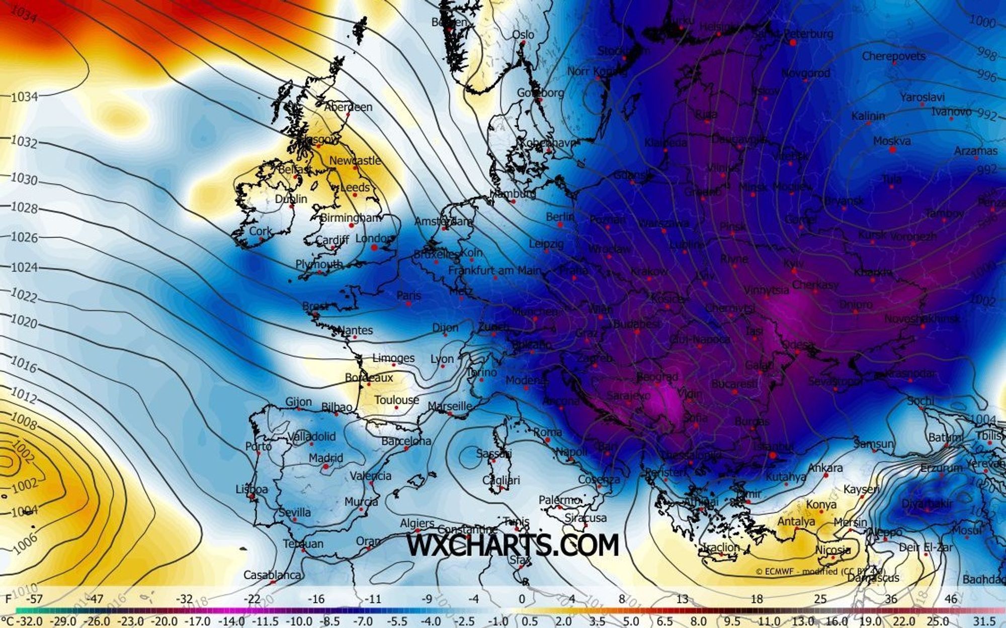
An abnormal pressure pattern has been causing major medium‑range uncertainty for days. The weather models are clearly struggling with it, though they are slowly moving closer together. The northerly upper‑level flow will bring cold to very cold conditions - on Wednesday mainly in the eastern half, and from Sunday temporarily across the entire Alpine region. The elephant in the room, of course, is the snowfall, and there are still plenty of uncertainties there. Let’s take a tour through the weather models to see where the chances of snow are highest.

- -20°
- -15°
- -10°
- -5°
- 0°
- 5°
- 10°
- 15°
- 20°
Animation of the temperature at the 850‑hectopascal level (around 1500 meters), showing two distinct cold outbreaks.
First cold outbreak brings a few flakes to the northeast
When a northerly flow is quickly followed by a ridge of high pressure, usually only the eastern Alps benefit from some Nordstau. That will also be the case in the coming days. The influx of polar air has already begun and will bring icy conditions to Austria tomorrow. At 1500 meters, temperatures will drop to around -10 °C, and at 3000 meters to about -20. Due to the strong wind, with gusts up to 80 km/h, the wind chill will be roughly 10 degrees lower.
In the Alpine foreland, the first flakes are already falling and through Thursday, occasional light snow will fall east of Innsbruck. Overall, it won’t amount to much, although 5-10 cm may accumulate in the stau regions of Salzburgerland, Upper Austria, and northern Styria.
Even larger temperature contrasts on Friday and Saturday
A second wave of cold air will reach the Northern Alps on Thursday afternoon. The regions along and north of the main Alpine ridge in Switzerland and Austria are heading for several icy days, with temperatures staying below freezing even during the day and down into the lowlands. In the Western Alps, the cold air will initially struggle to gain a foothold. The freezing level there, especially in the inner-alpine areas, will sit between roughly 1200 and 1800 meters and is not expected to drop into the valleys until Sunday. After that, wintry cold will maintain a firm grip on the Alps at least through 7 January.
Snow chances per weather model
Temperatures are rather snow-friendly but whether precipitation will occur depends heavily on the influence of passing disturbances. The forecast charts above show expected precipitation in millimeters through Sunday, which can be roughly translated into centimeters of snow. It is clear that the GFS stands completely on its own regarding the expected rain and snowfall in the western and southern Alps. Tonight’s and tomorrow’s runs will show whether GFS backs down or is actually onto something. For now, I assume the majority of models are correct and that the coming days will bring cold but little precipitation.
-
GFS: 20 to 50 centimeters in the western Alps, partly falling as rain below 1200-1800 meters. Also significant regional snowfall for the Dolomites, Slovenia, and southeastern Austria, with rain mixed in below 800-1200 meters.
-
ECMWF, GEM, AIFS, and ICON: No meaningful snowfall anywhere. Only some light Nordstau in the northern Alps.
Reaktionen
Thinking about travelling down on Sunday the 10th to catch an after storm condition Engelberg Jungfrau Disentis that area.