
- 1cm
- 5cm
- 10cm
- 15cm
- 20cm
- 30cm
- 40cm
- 50cm
- 75cm
- 100+
- 1mm
- 5mm
- 10mm
- 20mm
- 30mm
- 60mm
- 120+
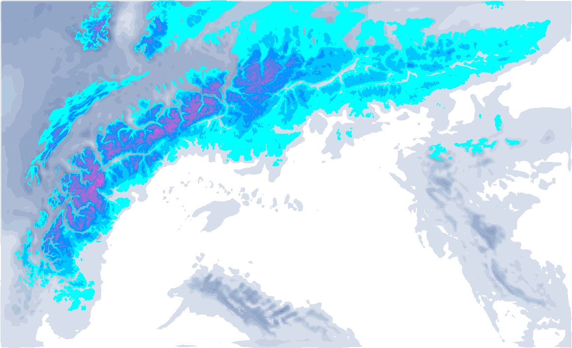
We get a northwesterly flow with lots of snow (and wind). Normally, we would expect a large area from the Haute-Savoie/Savoie to Vorarlberg to get a good amount of snow with a northwester, but now it is precisely the areas east of it, i.e. Tyrol and Salzburgerland. This is mainly due to a high-pressure area close to the French Alps, keeping it pretty much dry here. The snowline will not be all the way down into the valleys.

Tuesday during the day we already saw some snow. Today the storm increases with wind gusts to over 120 kilometres per hour possible. Many lifts are and will remain closed with the stormy westerly winds. In the south-west Alps, the föhn is also blowing hard.
The first precipitation follows in the afternoon, intensifying during the night from Wednesday to Thursday, especially around eastern Tirol and Salzburgerland. The snowline in Tyrol and further east will be between 1000 and 1500 metres (depending on the intensity), around the Arlberg and further west it will be milder, with a snowline around 1800 metres. Around the Hohe Tauern, 30 centimetres could fall, locally up to half a metre of snow is possible. In all directions, the amounts decrease rapidly. France and Switzerland remain as good as dry due to the high-pressure influence (only the easternmost part of Switzerland catches some). The emergency westward flow will also keep Italy dry (except the areas close to the alpine main ridge).

- 0-2 bft
- 3-5 bft
- 6 bft
- 7 bft
- 8 bft
- 9 bft
- 10 bft
- 11 bft
- 12 bft
The wind will remain quite strong in the process, especially higher up and also in the coming days. A new front with precipitation will follow for Austria on Friday evening. Again, it will not be cold and will continue to rain in the valleys. The snowline drops from around 1,500 metres slowly towards 1,000 metres. Large amounts will no longer fall, but higher up, some 5 to 10 centimetres could still fall.
Where to go?
Higher treeruns in eastern North Tyrol and Salzburgerland seem to be the best spots. The hotspots are mainly concentrated in the regions around the Zillertal Alps, the Hohe Tauern to the Dachstein massif. Also along the alpine northern edge, some models show quite a bit of precipitation, but here, of course, it becomes more difficult to look higher up, although of course with Krippenstein, among others, there are some possibilities. These high-resolution models also calculate the larger amounts still up to the Arlberg.

Beautiful weekend
In the night from Friday to Saturday, the precipitation rates decrease, after which the weekend then turns out to be beautiful due to increasing high-pressure influence. On Saturday, the core lies over the Alps and it will be very sunny, especially at higher altitudes. In the valleys on the northern side, some low-hanging clouds may linger longer.
Sunday will also be sunny, with milder air and increasing cloud cover from the west in the afternoon. In the Eastern Alps it will remain sunny all day and still slightly colder, but here too it will get a bit milder again at all altitudes with temperatures just above 0 degrees at 1500 metres. So over the weekend you can head higher up, but do check avalanche reports as the snow falls higher up with very strong winds.
Réactions
Excellent. Heading to Salzburgerland today. Thinking Kitzsteinhorn. Does that mountain tend to be very crowded on weekends? Any intel greatly appreciated :) Hopefully to get a few days of low powder panic skiing (but who isn’t?)
Thank you for the reports Henri!!
How do you think Montafron will be next week with the warm weather? Or would it be best to relocate?
Excellent. Heading to Salzburgerland today. Thinking Kitzsteinhorn. Does that mountain tend to be very crowded on weekends? Any intel greatly appreciated :) Hopefully to get a few days of low powder panic skiing (but who isn’t?)
andrewhDK - 25 Jan 2024 07:50
I was in Zell am see 2 weeks ago and we had a dump, the first day we went to Kitzsteinhorn which was on a sunday. It wasn’t that crowded but it got tracked out quite fast since you see the most of the runs from the lifts. The following 2 days we took the skibus to Hinterglemm and shredded untracked powder on Zwölferkogel. We had most success skiing between the Zehner 6er and Seekarlift.
French alps has spring