What a Retour d’Est! Yesterday it was snowing in full force and the accumulations got seriously big. Today, it’s time for a brief update on the state of play.
As expected, the largest accumulations took place from Prali to Ticino. Locally, up to 2 metres of snow fell within 3 days. Many lifts are and will remain closed for a while. Therefore, check carefully the websites/social-media pages of the ski resorts or give them a call. Ski areas are having a lot of trouble with the large masses of snow. Some villages/valleys are cut off from the outside world by avalanches, such as Gressoney. Over the next few hours it will quickly get warmer in this corner of the Alps, with temperatures rising to around 5 degrees at 1500 metres.
(Very) high avalanche risk
If you’re heading out now, really keep an eye on the avalanche reports and avoid steep terrain at all costs. Especially now on Monday, it is still very critical. Meteofrance has even issued avalanche danger 5 for this morning for Queyras and Haute-Maurienne. Avalanche danger is also high in Piedmont. Take time to read the avalanche report carefully.

Brief outlook
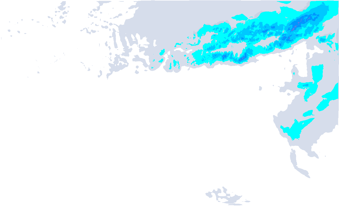
Today will be temporarily calm with more sunshine chances, but new precipitation will already follow on Tuesday. A low-pressure area passes over the Alps, which we can see a little better in the weather maps at about 5 kilometres altitude. With such a trough (slightly clarified with the black contour lines), upward movements can take place, which in combination with the mountains (additional upward movement due to orography) can cause snow. How much and where is still pretty hard to determine in such a situation, but our weather map below is pretty consistent with the general picture of many weather models. For this, slide the slider towards Tuesday and Wednesday.

- 1cm
- 5cm
- 10cm
- 15cm
- 20cm
- 30cm
- 40cm
- 50cm
- 75cm
- 100+
- 1mm
- 5mm
- 10mm
- 20mm
- 30mm
- 60mm
- 120+
The north-west Alps, especially central Switzerland, seem to catch a nice layer of fresh snow of around 20 centimetres. Higher up, even more could fall. A surprise of 30 to 40 centimetres is not even out of the question! The snowline drops towards the valleys during the evening on Tuesday.
In the evening and night into Wednesday, the snowfall shifts further eastwards. It snows not only in Vorarlberg and Tyrol with a snowline of around 1000m (initially above that, later falling towards most valleys), but also in the Italian Alps, Osttirol and western Carinthia (snowline 1200 - 1500m). Again, most areas will benefit with around 10 to 20 centimetres, but exceptions of some more are not excluded either. East of the Zillertal, on the other hand, I expect a lot less.
On Thursday, calm returns. Colder air enters the Po Valley, leaving the southern areas with more cloudy skies on Friday. A new low pressure system follows, allowing snow to start falling again in the southern Alps, with föhn in the northern Alps at the same time.
Réactions
Hey henri. Can you provide a snapshot of what you are seeing on the maps after next weekend. I see varying outcomes. Warm and wet. Cold and dry…need some guidance please. Thank you!
@ecsjones These varying outcomes are due to the fact that it’s too far in the future to know the details. As an example, the two last operational runs of the European model show this uncertainty:


Two consecutive operational runs with complete opposite patterns for next week Tuesday/Wednesday! My thoughts at the moment (but bear in mind the uncertainty!):
It will be a changeable start around the weekend, and after that, I think the mild to warm (south)westerlies will win, but we’ll just have to be a bit more patient. There is still room for surprises.
Surprise please! I always ask Santa for at least one surprise!
agreed. each run flips. need some luck here for mid month. keep us updated please, henri!
New Powder Alert to follow tonight! Snowfall over the next 24 hours is going to be substantial.