
A surprise PA with short and bright snow next night (Tuesday to Wednesday) and Wednesday during the day. Yesterday I already discussed the weather situation, but today I decided that the amounts are sufficient for PA#13 after all. A nice bonus for anyone currently in the Alps! But where exactly should we go for the biggest quantities?

Cut-off low
In the article on the southstau, I already briefly described the Gegenstromlage phenomenon. This time, however, it does not happen directly during a classic südstau, but thus with a cut-off low passing over the Alps and causing the wind to turn quite suddenly at high altitudes.
A seperate low-pressure core cuts itself off from the low-pressure complex over western Europe and passes over the Alps, creating the Gegenstromlage. This high cold air bubble (also known as cut-off low) can be clearly seen on the high-altitude maps. The temperature map at 500 hPa (about 5 km altitude) shows the cold bubble with temperatures below -30. The large temperature difference between surface and these high altitudes also makes the atmosphere fairly unstable. Combined with the orographic lift and the Gegenstromlage where moist air from the south slides over the colder air in the Northern Alps at altitude, precipitation amounts can rise significantly in this short period of time! Here and there, there could also be a clap of thunder.
Initially it will only snow above 1000 to 1500 metres, but due to isothermal conditions, the snowline on the northern side of the Alps will eventually be quite low. Especially in an area from central Switzerland to Tyrol, it could end up snowing down into the valleys. Narrow valleys have the advantage that there is less volume to be needed to cool down in this process, making these the first to see a low snowline. This drop in the snowline is highly dependent on precipitation intensity, so where it snows solidly, the snowline is also the lowest. Of course, that snow is quite wet in the lower layers because the temperature does not drop below 0 degrees here.

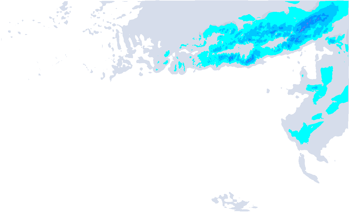
Up to half a metre of snow
I expect the most in the Swiss northern areas from Berner Oberland to eastern Switzerland (inneralpine a bit less) and around the Brenner (Southern Stubai and Ötztal Alps), see the map above. Here, 30 to as much as 50 centimetres of snow could fall higher up, locally some more as well. Further east (Salzburgerland) the amounts decrease very quickly, also in the French Alps the amounts remain limited. The eastern Dolomites (possibly also Ost-Tirol and western Carinthia) may also catch quite a bit with 20 to 40 centimetres.
The area of strongest snowfall, especially that one around the Brenner, has changed a bit more in the latest model runs (slightly more to the east), so it is also good to nowcast tomorrow and see where most of the snow actually fell. Also check the avalanche reports right away, as there are several factors to consider at the moment.
Thursday the sun returns
Wednesday it will continue to snow on the northern side throughout the day, although the intensity will continue to decrease. Thursday will then be the day. In many places, especially higher up, there is more and more room for the sun. In Austria, some low-lying residual clouds may remain for longer. It will remain a bit colder, especially here, while it will be warmer again from the west. Together with the returning sun, it will be a beautiful day! Be quick though, because from Friday the southern föhn returns and it gets very mild, also at higher altitudes. So, as with last week’s föhn, much of this snow will disappear again very quickly. The fresh snow is extra sensitive to this snow eater.

- 1cm
- 5cm
- 10cm
- 15cm
- 20cm
- 30cm
- 40cm
- 50cm
- 75cm
- 100+
- 1mm
- 5mm
- 10mm
- 20mm
- 30mm
- 60mm
- 120+
Then large amounts of snow again for the south?
After that, the signals seem to be back on green for heavy snowfall in the southern Alps. Taking the cumulative snow map for the next 6 days (see above), we already see the red colours returning. From Friday afternoon until Sunday, large amounts could start falling again. The French southern Alps and the entire Italian Alps seem likely to benefit, although the exact hotspots cannot be pinpointed at the moment. PA#14 thus does seem to be approaching.