
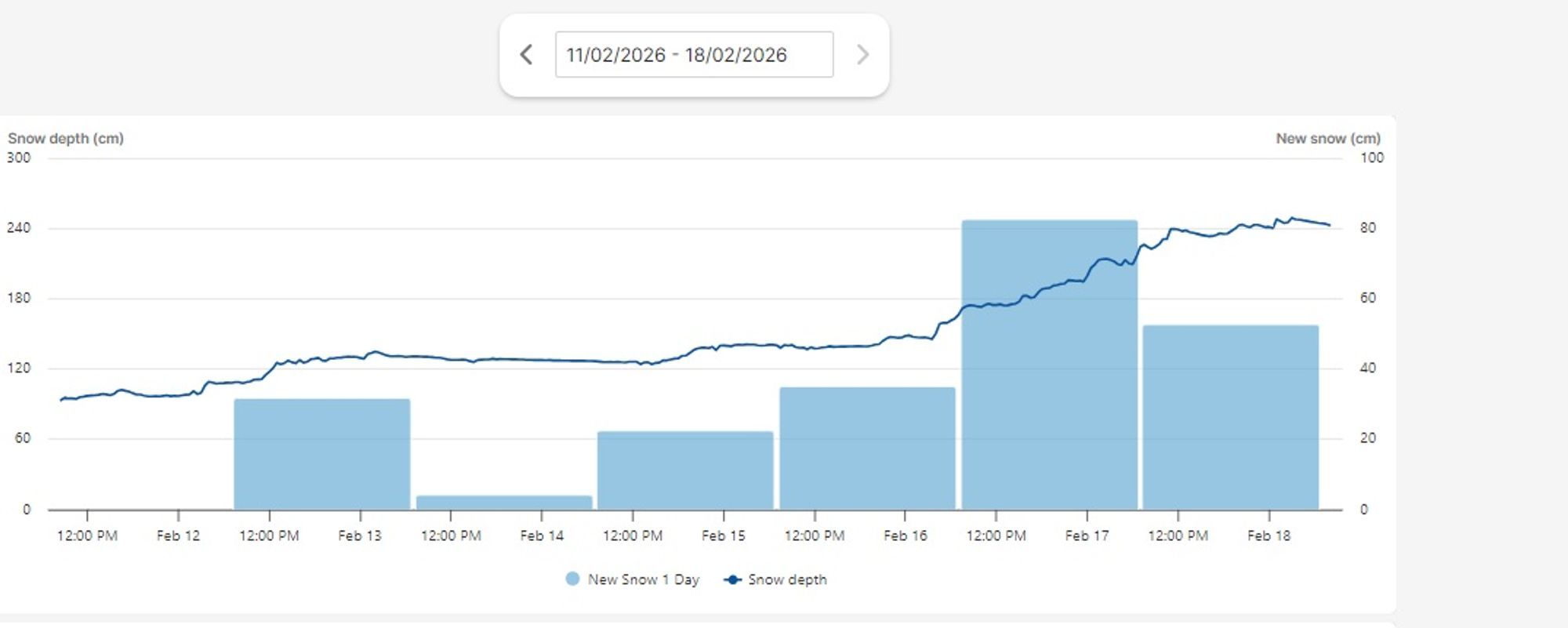
The prolonged dry spell leading up to the Christmas holidays, followed by heavy snowfall in recent weeks, has created a very critical avalanche situation. For weeks now, avalanche danger at higher elevations has remained consistently considerable, and at times even high to very high (French Alps and Valais).
Snowpack development this season
In the first Powder Alert of the season (23-11), we wrote:
“The intense cold during recent nights has caused a strong temperature gradient within the snowpack, stimulating the formation of faceted crystals. As a result, snow crystals become angular and lose their bonding strength. This can lead to the formation of a weak layer, which — with the snowfall still to come — may significantly increase avalanche danger.”
In the early season, several strong temperature fluctuations followed. During colder periods, surface hoar (a layer of frost crystals on the snow surface) also formed locally, later becoming buried under fresh snow. The result of this unfortunate early-season setup is that persistent weak layers developed across much of the Alps. Over the past two months, this translated into above-average avalanche activity. Even between major dumps, the danger level rarely dropped below Level 3 (Considerable).
Will the snowpack stabilise?
There are several conditions that can help stabilise a dangerous snowpack:
-
A longer period of mild, stable weather (settlement & sintering)
When the snowpack is exposed for several days to mild temperatures, little to no new snowfall, and minimal wind, the slab above can slowly settle and densify. This improves bonding between layers and reduces stress on the weak layer. -
Gradual, light snowfall instead of heavy loading
Persistent weak layers respond poorly to rapid loading. Small, gradual snowfall events — a few centimeters per day — allow the weak layer to adjust to the additional weight. -
Warming reaching the weak layer
Warming of the snowpack (through mild air and/or rain) reduces the temperature gradient. Faceting slows or stops, and crystals can round off. A strong warming phase or rainfall may initially destabilise the snowpack, but over the longer term it can help reduce weak layers through saturation and refreezing.
These are precisely the conditions we’ve rarely seen this season. Weather has remained highly variable, and stable periods were short-lived. Snowfall has mostly come in intense dumps rather than gradual loading.
The last stabilising factor — a significant temperature rise — is now approaching and could provide some relief in the final ten days of February, particularly on sun-exposed slopes below 2500 m. Above that altitude and on shaded aspects, the problem will likely persist.
Such a thaw period can, however, also create new weak layers (ice crusts) if followed by renewed cold and snowfall.
At the moment, avalanche danger in areas with recent significant snowfall is Level 4 (High) and is expected to remain so through the snowfall associated with PA#9 and into the weekend. After that, the danger may slowly decrease — but the underlying weak-layer problem will remain persistent.
Basic safety rules
With a PowderAlert, we normally try to advise which region to target. This time, the answer to “Where to go?” is more of a counter-question:
Are you sure you should go at all?
If you do go (or are already there), follow these principles:
- Carry full safety gear (beacon, probe, shovel, preferably also an airbag)
- Check avalanche bulletins
- Avoid slopes steeper than 30°
- Avoid terrain exposed to slopes steeper than 30° (avalanches are currently large enough to penetrate deep forest terrain)
- Do not enter terrain unless you know the route thoroughly
We regularly issue warnings, but this time they should not be taken lightly. Yesterday evening we spoke with an experienced mountain guide in the French Alps, who emphasised how extremely challenging the situation is — even for highly experienced experts. Why?
- Weak layers are fragile, invisible, and can be triggered remotely
- Frequent wind transport adds additional triggers
- Large amounts of fresh snow (up to 3 meters in 10 days!) mean that once triggered, avalanches become very large, reach high speeds in current powder conditions, and can penetrate deep into terrain normally considered relatively safe (forests, runout zones)
Avalanche statistics this season
The number of avalanche fatalities this season already stands at 86, well above last season’s total (70). These figures are tracked by the European Avalanche Warning Services (EAWS).
We are approaching the numbers seen in winter 2017/18 (147 fatalities), when persistent weak layers combined with heavy snowfall later in the season were also the main driver. Don’t become a statistic.
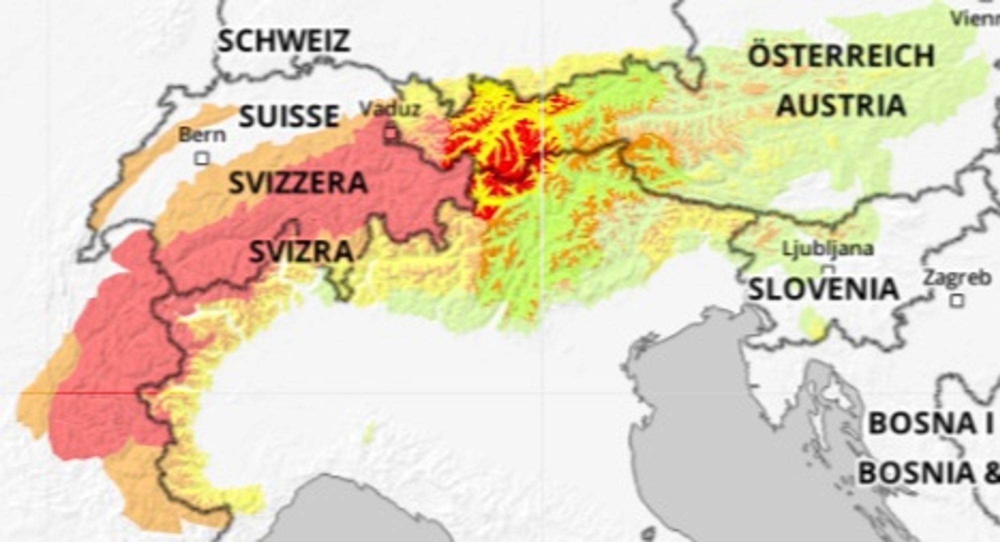
Distribution across Alpine countries is relatively even — which makes sense, as weak layers are widespread across the entire mountain range:
- Austria: 12 fatalities
- Switzerland: 18 fatalities
- France: 19 fatalities
- Italy: 18 fatalities
- Slovenia & others: 3 fatalities
Indicators of problematic snow structure in avalanche bulletins
To understand whether weak layers are present or developing, it’s essential to closely monitor avalanche bulletins. In English-language bulletins, terms such as (persistent) weak layer or failure layer are commonly used. These include:
- Surface hoar layer (SH)
- Faceted crystal layer (FC / FCxr)
- Depth hoar layer (DH)
- Near-surface facets (NSF)
- Buried surface hoar (BSH)
- Graupel layer (PPgp, sometimes weak)
- Crust–facet combinations (e.g. MFcr with FC above)
In German bulletins, look for terms such as Schwachschicht, Bruchschicht, Gleitfläche, and Altschneeproblem.
When an old weak layer is a key driver of avalanche danger, it is explicitly mentioned as “Altschnee” and often accompanied by the Altschnee pictogram.
Using snow profiles
Avalanche forecasters rely on weather data and snow profiles — and these profiles can also help you better understand local conditions.
Snow profiles are created by digging a pit in a representative slope. Experts then assess:
- Layer structure
- Crystal types per layer
- Colour and structure transitions
- Layer hardness
- Temperature gradients
- Compression tests to determine when weak layers fail
If you have recent field observations related to the current situation, feel free to share them in the comments.