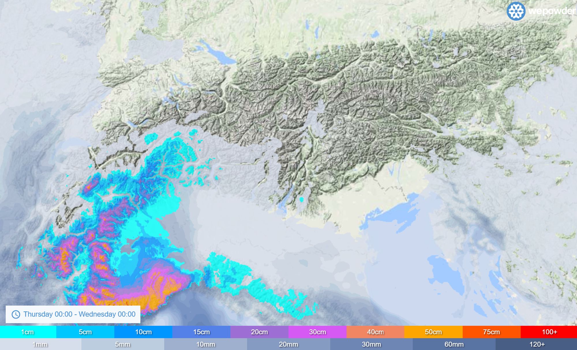
Over the past few days, snowfall prospects for the Southwestern Alps have become less and less promising with each new model run. It was already clear well in advance that the Dolomites would not benefit from this setup, but snowfall totals have also been revised downward in many other regions. Yesterday, Chris already pointed out the growing spread between the models. In this update, we take a look at what today’s model runs are serving up.

Small changes with big impact
The day before yesterday, I wrote about a trough that could bring snow to the Southern Alps starting on Friday. In subsequent model runs, however, the high-pressure block east of the Alps became increasingly dominant, eventually wiping out that scenario almost entirely. I’ve placed the two charts (from the day before yesterday and from this morning) side by side to show that while the overall pattern looks very similar, small differences can still have a huge impact on the key question: snow or no snow. In this overall case, ECMWF seems to outperform GFS, as its entire ensemble had already been significantly lower for some time.
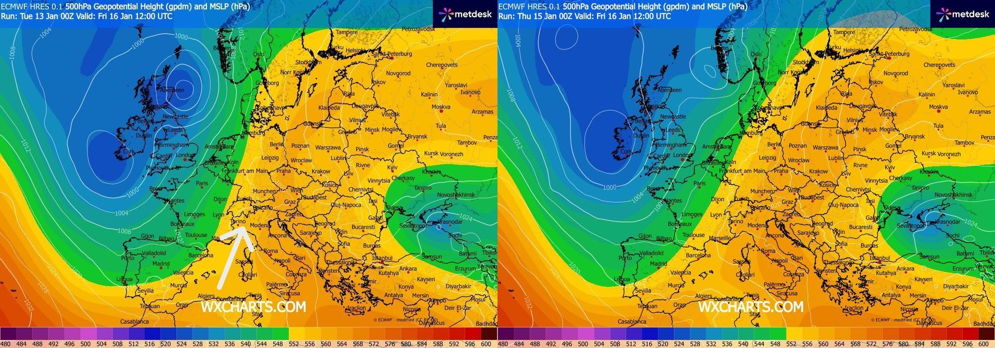
On the left: the ECMWF run from the day before yesterday for Friday 12 UTC. On the right: a very similar large-scale setup from today’s run for Friday 12 UTC — but with major differences in the details.
On the upper-air charts above (500 hPa, roughly 5.5 km altitude), the latest runs still show a very similar trough, but one that has been pushed slightly farther west by a more dominant high-pressure block stretching from southern Italy to the Baltic States. This high remains dominant through the weekend and continues to block incoming systems. Still, a pocket of cold air manages to detach from the main flow and temporarily settle over the Mediterranean. As a result, the flow quickly turns southeasterly, without a classic Südstau developing first, limiting snowfall to just a small corner of the Southern Alps.
Two snow phases
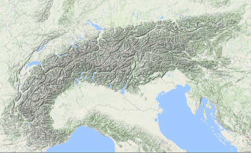
Aside from some light snowfall in Ticino and surrounding areas starting tonight, the first real snow is expected in Piedmont and the French Southern Alps from Friday into Saturday. Initially, temperatures will be relatively mild, with the snow line mostly between 1300 and 1600 meters. The models, including several high-resolution ones, still show large discrepancies in snowfall amounts, meaning this first phase will require some nowcasting to be done. From the Écrins to the Maritime Alps, I’m currently expecting around 15 to 30 cm, though locally higher amounts are certainly possible. Especially on the French side, showers activating over the Mediterranean with the right track could deliver locally higher totals (hence the need for nowcasting). Areas north of Turin should see 10-20 cm, with locally higher amounts in favored stau regions. On the 24-hour snowfall forecast below, you can use the slider to see what is expected to fall during this first phase through Saturday.

- 1cm
- 5cm
- 10cm
- 15cm
- 20cm
- 30cm
- 40cm
- 50cm
- 75cm
- 100+
- 1mm
- 5mm
- 10mm
- 20mm
- 30mm
- 60mm
- 120+
During the day on Saturday, precipitation intensity will decrease, but snowfall may persist a bit longer in western Piedmont due to continued orographic lift. The second phase arrives during the course of Sunday and continues through Monday. Colder air flows in from the east, allowing the snow line to drop to generally lower elevations. It starts around 1000-1200 meters but may fall into many valleys as snowfall continues. According to several models, totals remain fairly substantial, but this time the focus is mainly on the Italian side (with the exception of French border regions that benefit from a retour d’Est). As a result, true powder days should be found in Piedmont from Monday onward, with up to around half a meter of fresh snow possible from Prato Nevoso to Prali. One advantage of snowfall in this region is the solid base already in place from the PA#2 event, meaning less new snow is needed to enjoy quality powder conditions.
Farther north, expected snowfall amounts are lower, but the outlook is not necessarily bad. For the medium term, however, I remain a bit cautious, as the “backside” of this snow event has also become more limited: on Tuesday, increasingly cold continental air flows into the Po Valley from the east, and skies clear over a wider area. As always, we’ll keep a close eye on the situation and may issue a new PA in tomorrow’s forecast for early next week.
Reacties
Any hopes for a good retour d’est in the Monte Rosa region?
so no more than 30cm in 4 days huh. kinda disappointing but alright
guess I’ll have to go south
I will be in Prato Nevoso. Anyone up for skiing?
I will be in Prato Nevoso. Anyone up for skiing?
Camusch - 16 Jan 2026 00:32
If you’ve been to Limone Piemonte as well, which one is better in your opinion?