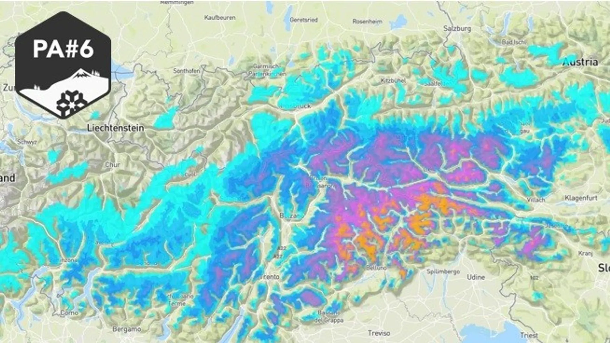
The precipitation phase of PowderAlert #6 continues to deliver a solid load of fresh snow to the southeastern flank of the Alps through Thursday morning, after earlier snowfall already refreshed the Alpes Maritimes, Écrins, and Piemonte.
Today we zoom in on:
- Snowfall for the South (Eastern) Alps
- The long-awaited snowpack comeback after a very poor start
- A shifting focus toward the Western Alps
- Calm before (and north of) the storm
- Pattern change mid next week
Snowfall for the South (Eastern) Alps
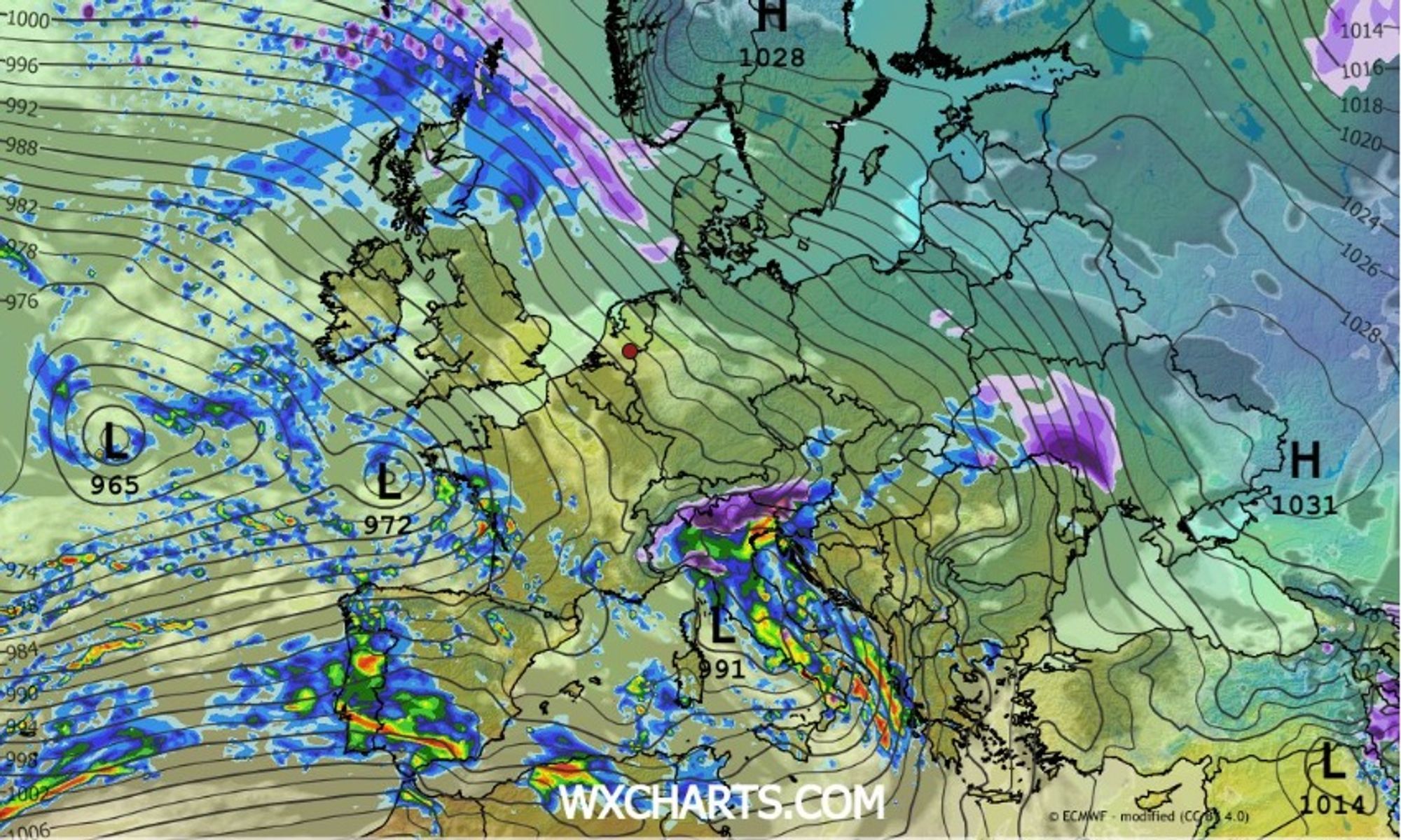
A deepening low-pressure system moves across Italy toward the Adriatic Sea, anchoring near Venice by Thursday morning. On its eastern side, a strong southerly stau develops today, targeting the Dolomites, Carinthia, and especially the Julian Alps.
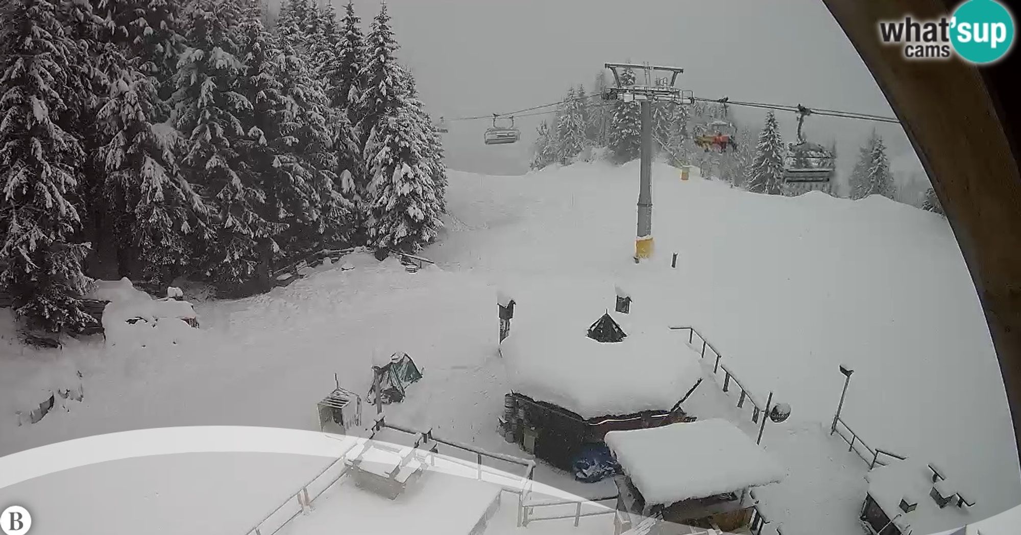
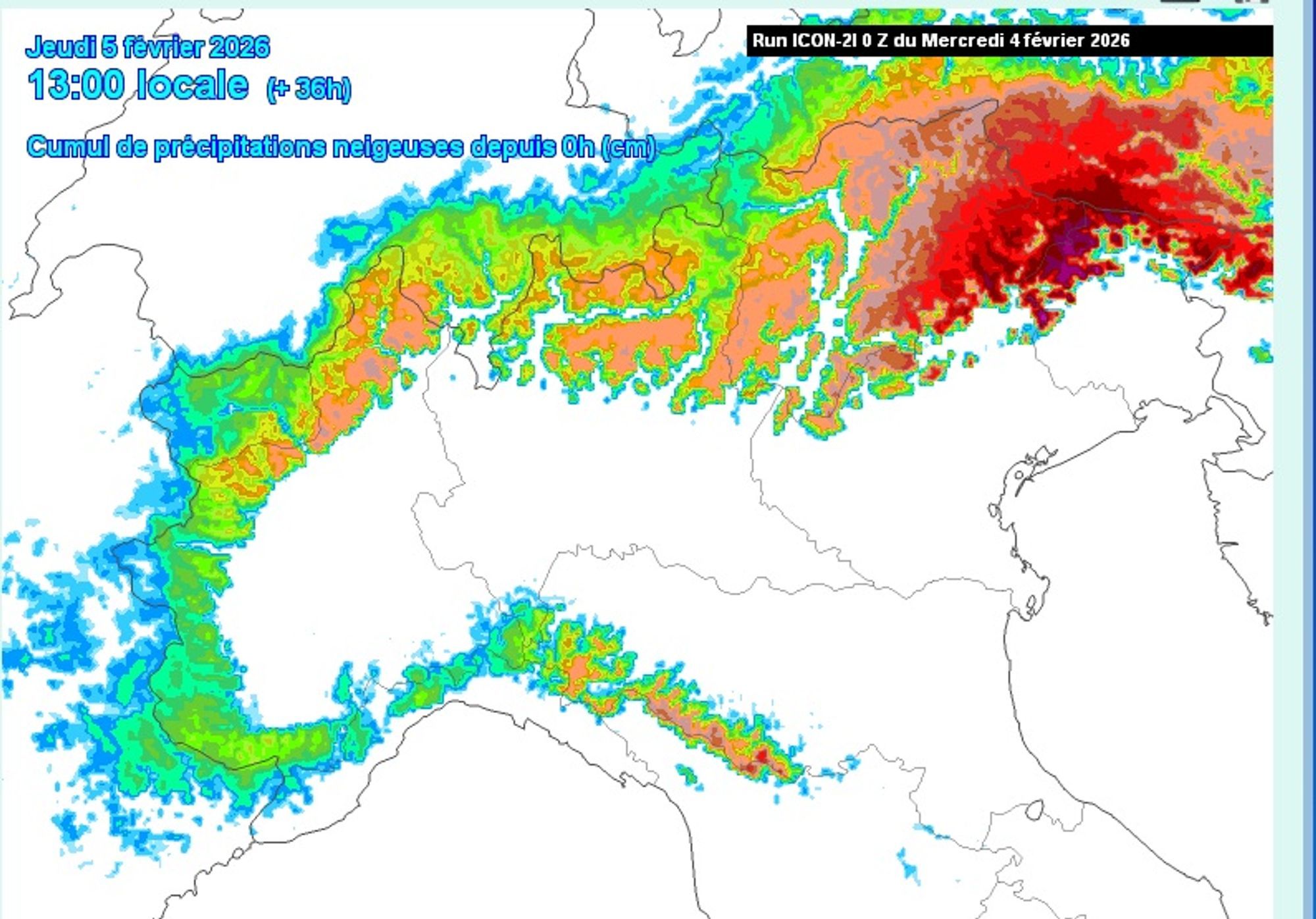
Snowfall intensifies mainly this evening and overnight, with totals ramping up quickly. In the southern and eastern mountain regions, 30–60 cm of fresh snow is possible by tomorrow morning. In the Dolomites (where the stau phase is shorter) and further north in Carinthia, expectations are around 20–30 cm. The air mass isn’t particularly cold, but thanks to high precipitation intensity, the snow line remains relatively low. In Italian valleys that get the full hit, the snow line may drop below 1000 m, while further north it sits around 1000–1300 m. In Piemonte and Ticino, another 5–10 cm falls today above roughly 1000 m.
Snowpack comeback after a very poor start
Snowpack levels compared to seasonal averages still vary widely across the Alps. Parts of Switzerland and Austria continue to struggle with a thin snowpack, while the southern French Alps and Piemonte now report near- or above-average amounts. Over the past ten days, snowfall has added up further — but the biggest improvement is clearly in the eastern Southern Alps. PA#5 and PA#6 (still ongoing) delivered several fresh rounds, finally building a continuous snowpack above ~1000 m.
Current snapshots:
- Around 1500 m: 30–70 cm (e.g. Ponte di Legno, San Caterina Valfurva)
- Around 2000 m: 60–100 cm (e.g. Livigno, Pinzolo, Canazei)
In the Julian Alps, the snowpack will be even deeper after the next 24 hours. One notable feature is how slowly snow depth increases with elevation, a direct result of the extremely thin base (<40 cm) that persisted here until about two weeks ago.
While snowdeck height differences remain across the Alps, the common ground remaining unfortunately is the unstable base. The snowpack structure still shows a fairly uniform weakness across the Alps. Old fragile layers (faceted snow, surface hoar) persist beneath the fresh snow. As a result, avalanche danger remains elevated (level 3) and can quickly rise to high (level 4) during periods of heavier snowfall. Today’s avalanche maps already show high danger in parts of the French and Italian Alps.
Wherever you go: choose conservative terrain and always check the bulletin, for example here
Focus shifting toward the Western Alps
After the snowfall of PA#6, Thursday looks relatively calm across the Alps. A clearing zone moves from west to east: clouds linger longer in the east during the morning, while in the west the next precipitation system already announces itself. A new intensifying low moves toward the Gulf of Genoa by Friday morning, bringing yet another precipitation zone. This system sweeps across the Alps fairly quickly between Thursday evening and Friday evening. With a southwesterly upper-level flow, the French Alps — and possibly Valais and Piemonte — are favored once again. Model spread remains large due to uncertainty in the low’s track, but 10–25 cm of fresh snow looks realistic for the Western Alps, with the Écrins once again in the spotlight. Snow line: 1000–1600 m, lowest in inner-Alpine valleys and on the Italian side of the main ridge. Snowfall for the northern French Alps and Ticino remains uncertain, while the Northern Alps likely only catch a glancing blow on the backside of the stau zones.
Calm before (and north of) the storm
Over the weekend, the atmosphere temporarily settles over the Alps. Low-pressure systems track even further south, causing severe weather and flooding risks especially in Spain and Portugal. In fact, much of the Mediterranean region faces very wet and stormy conditions in the coming week. The jet stream takes an unusually southern path, bringing extreme wind and precipitation, along with numerous weather warnings across Mediterranean countries. Expect renewed snowfall in the Pyrenees, though with highly variable temperatures and stormy conditions.
In the Alps, southern regions remain sensitive to cloud cover and occasional light snowfall, but large accumulations are unlikely. On the northern side of the Alps, clearing is more likely. Temperatures stay moderate, with afternoon values around or slightly below freezing at 2000 m.
Pattern change mid next week
Looking ahead, it appears that mid next week, unsettled weather will return to the Alps in full force. A new low-pressure system develops and takes a much more northerly track, significantly increasing the chance of meaningful precipitation. Given this northerly trajectory, substantial snowfall is likely on the (north) western side of the Alps.
Reacties
Hi!
Thanks for the recent update on PA6. I would love to get your opinions on where to go to for a short Friday to Tuesday trip. We are searching some resorts that might avoid the worst weekend crowd and will have some nice treeruns. At first glance it looks like somewhere south of Mt Blanc is the direction, but would love to hear some advice regarding specific resorts. I have the Wepowder guide accompanying me on the trip.
Joe, Norway
Joakim, Norway.
Hi!
Thanks for the recent update on PA6. I would love to get your opinions on where to go to for a short Friday to Tuesday trip. We are searching some resorts that might avoid the worst weekend crowd and will have some nice treeruns. At first glance it looks like somewhere south of Mt Blanc is the direction, but would love to hear some advice regarding specific resorts. I have the Wepowder guide accompanying me on the trip.
Joe, NorwayJoakim, Norway.
JoakimS - 05 Feb 2026 13:59
You might consider the Ecrins (Puy, Pelvoux, Serre).
Thanks for quick reply! Looking forward to all updates.
Joe