The Alps are under the influence of a current turning from west to north. It’s been raining and snowing in the northwest and north of the Alps since Friday. At the same time the sun dominates in the southwest and south of the Alps. The snow line was again high with rain up to high altitude (1700-2300 meters) during the night from Sunday to Monday, but cold air arrives from the north today (Monday morning). Once the cold air enters the mountains, the snow line will drop rapidly. The cold air then squeezes the last snow from the humid air and more and more valleys in the north of the Alps become white. But with all the fresh snow, rain from the last days and strong winds, the avalanche danger has increased in large parts of the northern Alps to HIGH (4 on a scale of 5). In this forecast:
- A lot of snow in the high alpine, greener than normal lower on the mountain
- Monday: northern Alps will get snow and rapidly dropping snow line
- Everything about the snow line
- Strong winds cause acute avalanche danger
- Christmas Day: sun and fresh snow in the northern Alps
- Where to go?
- Another northern Stau?
A lot of snow in the high alpine, greener than normal lower on the mountain
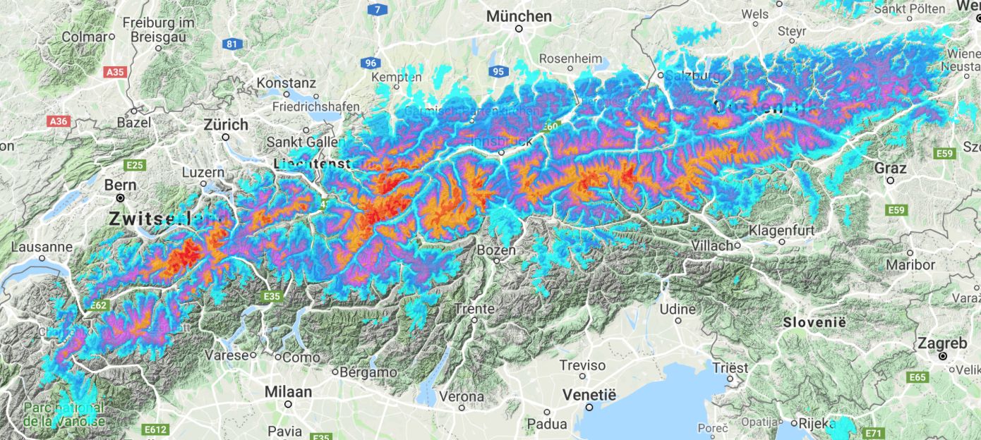
It has been snowing and raining from time to time in the northwest and north of the Alps since seven days. A lot of snow came down in November as well, so we can’t complain. The high alpine in the Alps have a snow cover that is thicker than normal, although the differences can be quite large. In addition to a lot of snow, the wind has been strong the last few days. In one valley you can ride great lines above 2000 meters, while the other valley has almost no snow, or a snow cover that’s been soaked up to 2500 meters. Local knowledge is a must and anyone who is riding with locals or a mountain guide in the coming days will reap the benefits.
The above video is from La Grave with a bizarre amount of snow on the glacier. (Thanks @ martijnschell for sharing). The snow cover is much thicker than normal in large parts of the Alps above 2000 meters. But on the other hand, the valleys are much greener than normal. In large parts of the Alps there is clearly less snow below 1500-2000 meters than is normal for the time of the year.
Monday: northern Alps will get snow and rapidly dropping snow line
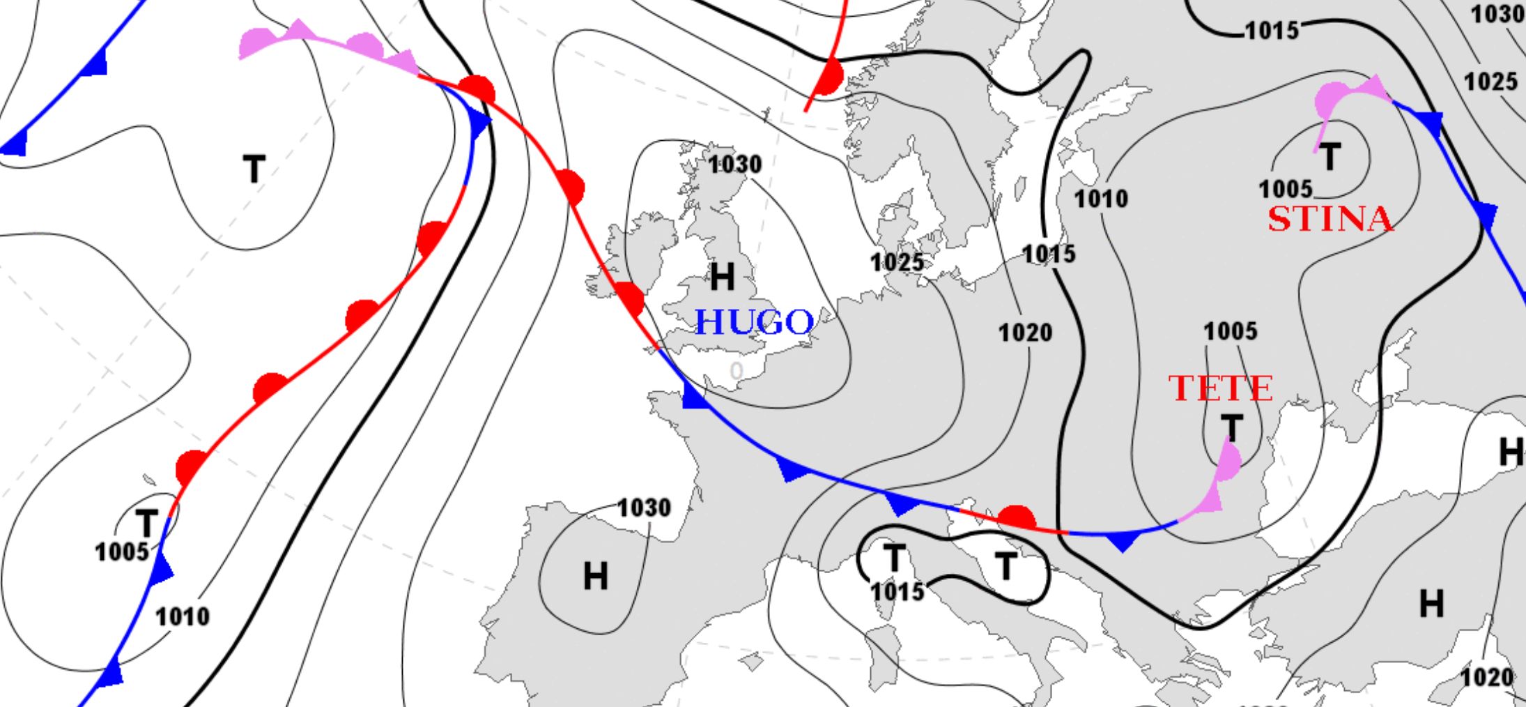
On the map above you can clearly see how the high-pressure area Hugo is coming in from the west. Storm Tete has already passed the Alps a while ago. But between Hugo and Tete there is a powerful northern current that transports cold air to the northern Alps. The air pressure may be high, but still it will snow heavily. In the forecasts from Thursday and Sunday I have already explained in detail why it can still snow heavily with such an air pressure.
Warm air is trapped and pressed against the Alps by the rapidly incoming cold air. In addition, the mild and very humid air is stuck and forced to rain and snow empty.
Everything about the snow line
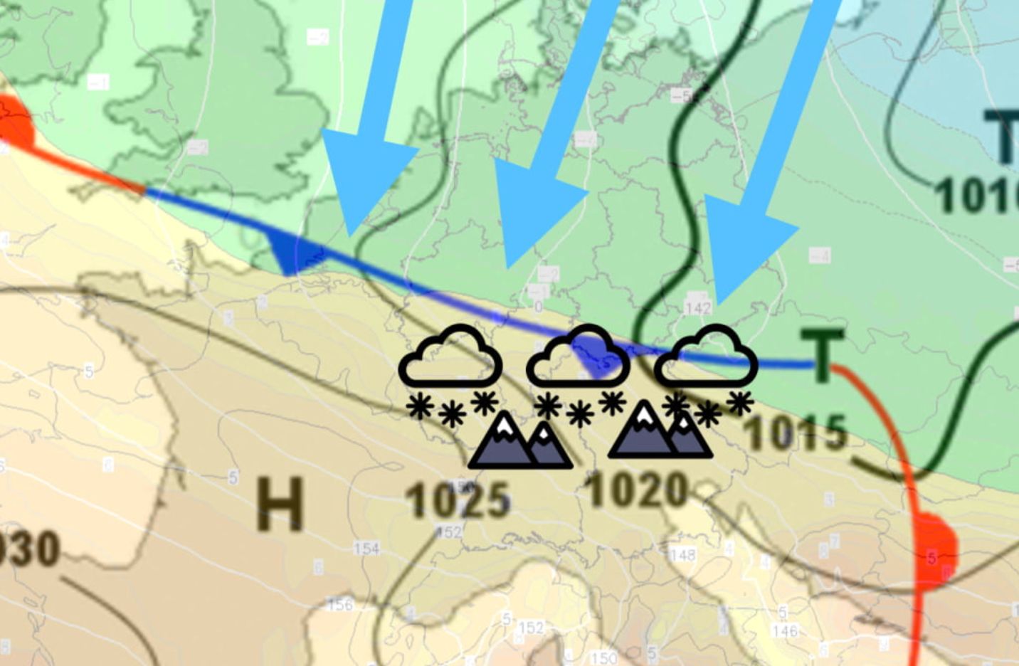
Some basic physics: cold air is heavy, warm air is lighter. In a situation without mountains the cold air pushes the warm air up, it rises, cools down, condenses and it will rain and/or snow. But now we are dealing with a complex situation where various layers of air are mixed together. Because of the mountains and the deep valleys it is hard to predict where the cold air directly enters the valley and where moist air lingers longer. It is therefore very difficult to predict the course of the snow line for the Monday.
In general you can say the following: the snow line was still high in the night to Monday and will drop in the course of Monday. First of all in the east of Austria, but also in the west of Austria and Switzerland in the course of the day. By the end of the day it will also drop in Wallis and the northern French Alps. In the east I expect the snow line to drop to 300 meters, around the Arlberg to 1000 meters and on the border between Wallis and France to 1500 meters. For the northern Alps this means that in most ski resorts it will turn white at Christmas, but that one village will see cold air sooner than the other village.
Secondly, there is the amount of snow that will fall. For the entire northern Alps there is a thick pack of snow falling above 1700-2100 meters, with quantities between 50 and 100 cm, locally also more. But if you go further to the west (French northern Alps, western Wallis) you will at most see 20-40 cm (locally maybe 50 cm) coming down. The high alpine will get a lot of snow again.
Low and mid-mountain will get much less snow. Although there is cold air and it will be white in most ski resorts in the north, the amount of snow that falls when the cold front enters is quite different. In the east (where the cold air flows in faster) I expect more than 20-50 cm of fresh snow above 1000 meters. More to the west, this amount will only fall above 1600-1800 meters and often also clearly less.
Strong winds cause acute avalanche danger
Rain, lots of fresh snow and lots of wind result in acute avalanche danger. The avalanche danger is now HIGH (4 on a scale of 5) in many regions. The right knowledge is more than useful when you’re riding off-piste. Always check your local avalanche forecast and adjust your plans to it. (Tip: on wepowder you will find a link to the local avalanche forecast at each village, but you can also visit this page). As mentioned, a good ski, snowboard or mountain guide makes a difference, especially on days like this.
Christmas Day: sun and fresh snow in the northern Alps
It will be sunny in the Alps from Christmas Day. It was already sunny in the southwest and south, but the sun also appears in the French northern Alps and the northern Alps during Christmas. Only in the far east of the Alps you might expect some snow. It will also be sunny on Boxing Day and the days after. It will be mild and sunny in the south and west, but it is clearly colder in the east.
PA#4: Where to go?
Powder chasing during Christmas? That is certainly an option. With the snow that still falls today, Christmas will be good. But where to go? Around Chamonix and western Wallis there is certainly some snow, but personally I wouldn’t opt for those areas. Who really wants to go deep must be around the Arlberg or the glaciers in Austria. There is also a lot of snow coming down north of the northern alpine ridge in Switzerland. But pick areas with enough terrain above 1800-2100 meters. Exceptions are the northern Stau regions of the Salzburgerland and Styria (read: the north). The cold has flowed in faster here and you can also ride powder on lower alpine meadows.
This is the PowderAdvice for the next couple of days:
- The north and northeast of Graubünden
- The highest resorts in Vorarlberg, especially the Arlberg region
- The Arlberg, Silvretta Arena and the glaciers of the Kaunertal, Pitztal en Sölden in Tyrol
- The Hohe Tauern (the resorts in the south at higher altitude) and the alpine meadows in the north of the Salzburgerland
- The north of Styria
When the storm has passed there will certainly be other high altitude resorts in the northern Alps that have something to offer, but if you follow the recipe above and if you’re flexible enough to go that way will find great powder during Christmas. Good luck with your powder chase!
:nopro:
As wePowder Pro you get access to the 14-day snow and weather maps and the 14-day forecast per resorts (we’ve got all the resorts in the Alps covered). You never have to miss a dump anymore. When you are wePowder Pro you also have access to 1000+ inspirational freeride routes in the most beautiful freeride areas of the Alps. Sign up as wePowder Pro today. It works great for your karma as well and you’ll support the development of the wePowder platform! Thanks!
:nopro:
Another northern Stau?
It will be sunny from Tuesday, but there is a chance that we will see a small northern stau on the north side of the Alps from Friday. With a northern current the north of Austria and later also the north of Switzerland might be in the line of fire. All still uncertain, but who knows.
Stay stoked,
Morris
Reacties
Snow levers are dropping. At Engelberg snow level at 1100 meters at the moment
Significant fresh snow at the Montafon
Check how deep the snow pack is at the top of the Jakobshorn Davos. Yesterday afternoon this terrace was snow free
Xmas white at Lech and Andermatt
The weather stations in Switzerland do show how the cold air is moving in from the east
It is snowing in Crans Montana. Below 2200 the snow is very heavy and below 1800 is brown and very thin after the warm rain.
Merry Christmas!! With a lot of sugar for dessert!!!
Merry Xmas… Andermatt on 9th January…
https://cdn.wepowder.com/site/forum/14/a5307577d3754e2b67728613054529e6_image_1.jpg?width=800\
Winter is back in the valley… one of the most intensive snowfall that I’ve ever seen, it all came down in less than three hours
Greetings from a White Sedrun
@@juancarlosdominguezlemoine @@Mountainlodge thanks for the reports!