PowderAlert #4 is coming up. The northern Stau arrives with lots of snow for the northern Alps. Just be patient and Christmas will be white on the north side of the main alpine ridge. Isn’t that great, especially it was raining cats and dogs in the west and northwest of the Alps since Friday night. The snow line rises to high altitude again on Sunday, but there will be low temperatures and snow deep(er) in the valleys on the north side of the Alps from Monday. In short: from Monday the chase for Christmas powder starts. Wax up!
In this forecast:
- Rain ended a wonderful week
- Rain again in the north up to high altitude on Sunday
- The northern Stau will arrive on Monday
- Powderalert #4, the last one of 2018?
- Very sunny from Christmas
Rain ended a wonderful week
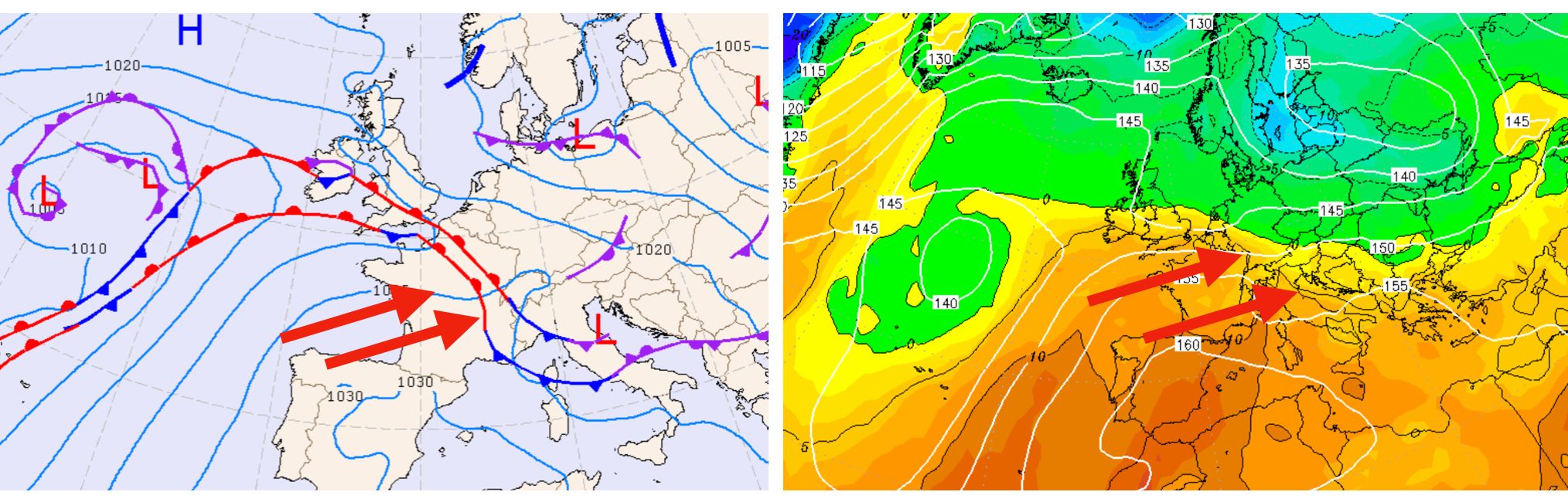
We’ve enjoyed PowderAlert #3 last week. The northwest of the Alps received quite a bit of snow and the conditions were good above 1600-1900 meters. But a nice week came to a brutal end on Friday. A strong storm with very mild air pushed the snow line towards the 1800-2500 meters in large parts of the northwest of the Alps. It was only colder in the inneralpine areas. Reports of rain came in up to 2500 meters altitude from the Savoie and west of Switzerland and even in Vorarlberg it rained to about 1900 meters.
Rain again in the north up to high altitude on Sunday
Today (Saturday) a cold front gently touches the Alps, causing the snow line to drop and snow to fall above 1400-1700 meters. But on Sunday there is a warm front coming in from the southwest. The precipitation front touches the north side of the Alps and because the air is mild it rains again, during which the snow line climbs to about 1800-2200 meters during the day. The snow line remains on the high side also in the night to Monday.
The northern Stau will arrive on Monday
From the forecast from last Thursday: 'Something very interesting is about to happen on the 24th of December. Cold air reaches the northern Alps. Cold air descends over the eastern flank of a high-pressure area towards the Alps. The air pressure is high, the air is relatively dry and normally it produces little snow, but… The mild and humid air of Sunday afternoon is still just north of the Alps and is trapped between the cold air that descends from the north to the Alps on the one hand and the Alps on the other. That cold air presses that damp air against the Alps and the result is snowfall deeper in the valleys in the night to Christmas. This results in a lot of snow in the current calculations, with which Christmas morning has a white start in many ski villages on the northern side of the Alps.
With the map below I made an attempt to show you what is about to happen. As said before, a warm front has passed on Sunday. The corresponding arrow can still be seen to the right of the Alps. In the meantime, high pressure is picking up from the west (the H to the right of the Alps). Between the high-pressure area (the H) and the storm of Sunday (the T) a north-northeast current arises (the blue arrows). With this northern current, cold air is transported from the north to the Alps. The separation between the warm air hanging north of the Alps and the cold air from the north is the blue line (the cold front). Normally, such a cold front does not produce much snow at an air pressure of 1020 hpa (which is high). But now the warm air (which can contain much more moisture) gets stuck between the Alps (the mountain icons in the picture) and the cold air. This cold air pushes the mild air from the north into the Alps. The result is that the moist, mild air must rise and cool off quickly due to the rise and because of the incoming cold air from the cold front. The result is a huge drop in temperature and fast condensation with lots of snow for the north side of the Alps.
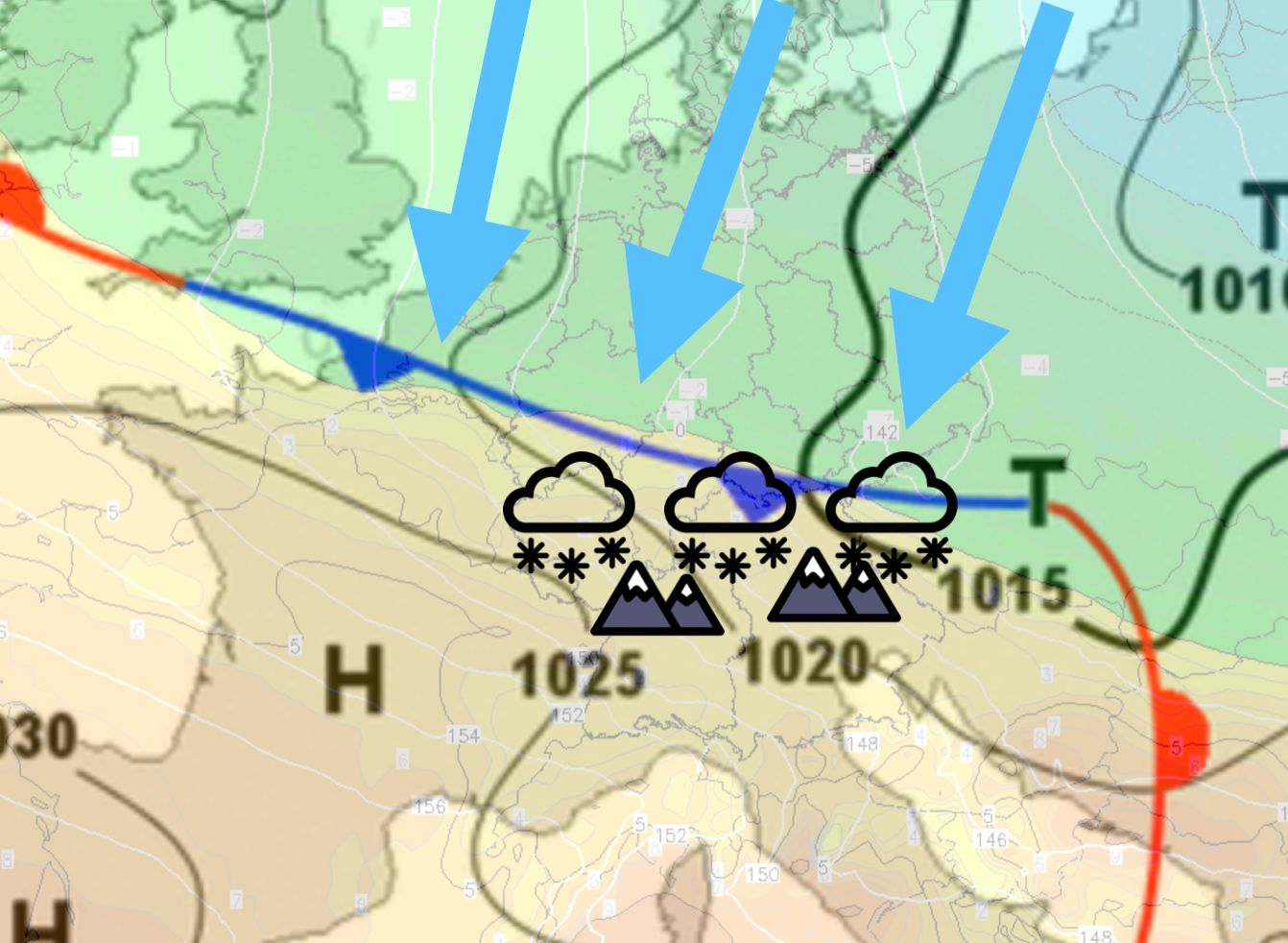
The snow line that is still very high in the night to Monday drops in the course of Monday to 1000 meters or below. In addition, you can expect some snowfall!
Powderalert #4, the last one of 2018?
After the cold air has squeezed all the snow out of the clouds, the high pressure from the west is increasingly taking hold of the Alps. It’s already sunny in the southern Alps and large parts of the Western Alps on Sunday and Monday, high pressure also ensures a lot of sun in the mountains from Tuesday. The last calculations assume that this high pressure area will determine the weather in the Alps to the new year, with which PowderAlert #4 also becomes the last alert of 2018.
In short the chase:
- Sunday and Monday: wax up and countdown has started
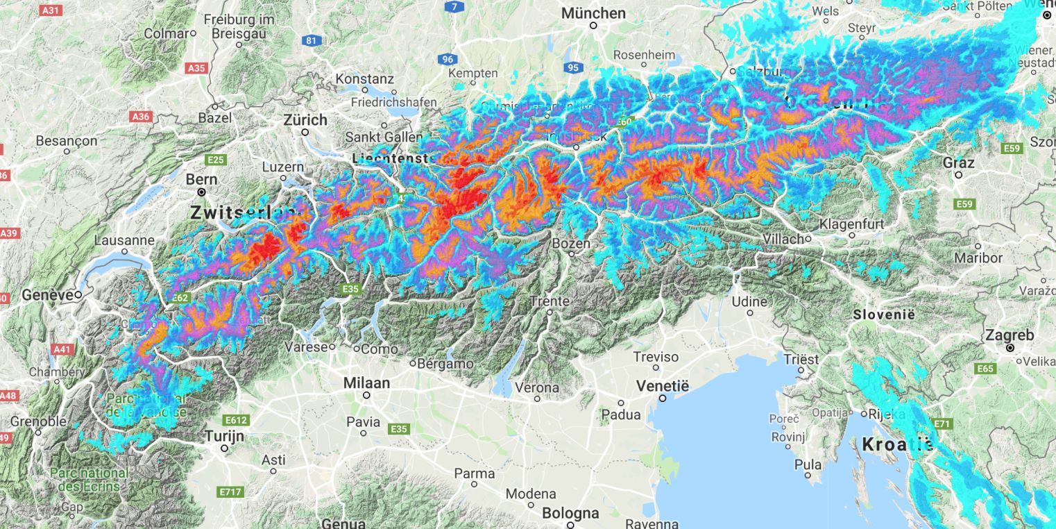
- Tuesday: all resorts in the northern Alps will have a powder day. From Gstaad to Hochkar. There is a lot of fresh snow everywhere. The best areas are the areas where there is already a thick base.
- Wednesday and Thursday: A lot will be tracked out in the usual suspects on Christmas Day, but there is still plenty of powder in the smaller resorts
- Thursday and later: time for some hikes in the backcuontry or go touring
:nopro:
As wePowder Pro you get access to the 14-day snow and weather maps and the 14-day forecast per resorts (we’ve got all the resorts in the Alps covered). You never have to miss a dump anymore. When you are wePowder Pro you also have access to 1000+ inspirational freeride routes in the most beautiful freeride areas of the Alps. Sign up as wePowder Pro today. It works great for your karma as well and you’ll support the development of the wePowder platform! Thanks!
:nopro:
Stay stoked,
Morris