A northern Stau is a term I often use in my weather forecasts and that often results in positiev reactions. But I also get some questions every now and then about this phenomenon that makes people cancel meetings, travel for hours or sit depressed at their desk when they can’t make. This is everything you wanted to know about a northern Stau, but were afraid to ask.
Heavy traffic
If you drive a car on the highway every now and then you sometimes hit heavy traffic. The cars come to a stop due to an obstacle. That obstacle can be a roadblock, an accident or something else. That’s no different in meteorology. Stau means air masses hitting an obstacle, in this case a mountain that stops the current and forces it to rise. As a result, the air cools down, it starts to condensate, clouds are formed and it starts to rain or (if it’s cold enough) it starts to snow.
Northern
This term is much simpler. It indicates the direction from which the current is coming. In this case the current is coming from the north and wants to bring the air to the south. And then, all of the sudden, it hits the Alps, is forced to rise and it will snow.
The Alps as an obstacle
You can see how the clouds (white) flow down and cling to the Alps on the video above. The Alps are the obstacle and beacuse the Alps are at a ninety degree angle to the current the effect is optimal. The clouds can’t go anywhere and are forced to rise. It will snow and rain on the north side of the main alpine ridge. This leads to typical northern Stau maps like the one below (source: wePowder forecast):.
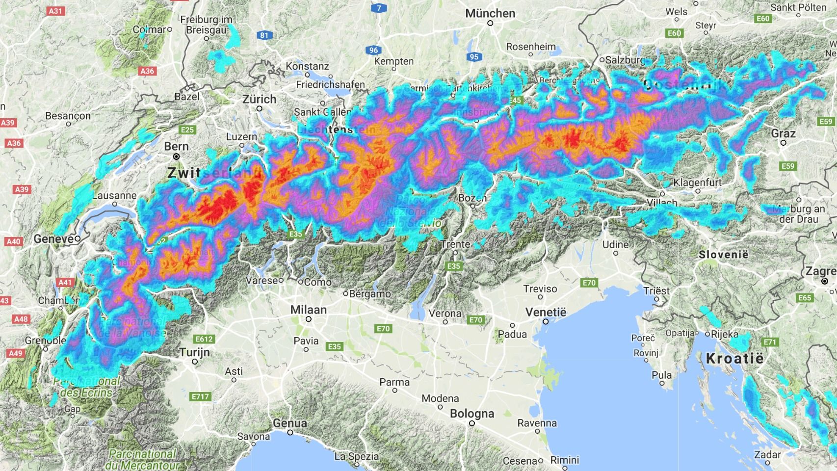
The map above is a perfect map that provides the complete north side of the Alps with fresh snow, but sometimes a storm is just a little further west or just east. That causes differences in the snowfall on the northern side of the Alps. During a north-west current, most of the snow falls in the north-western part, and if the current is coming from north Switzerland and Austria will get hammered. When there’s a strong high-pressure area above France, snow will often only fall in Austria. But in general you can check out the resorts that benefit from a Stau from the north below (in gray / blue).
Consequences for the northern Alps
You can expect heavy snowfall foinr the ski areas in the gray / blue regions on the map above. There is an important difference between the warm front and the cold front. There’s a lot of precipitation at the passage of the warm front, and it can reach deep into the main alpine ridge (or even beyond the main alpine ridge). After the passage of the cold front, the wind turns from the northwest to the north / northeast and a new stau period with the center of gravity in the lower and middle mountains of the pre-Alps kicks in (mainly the blue area on the map above).
Consequences for the western Alps
With such a current, you can divide the western Alps into the northern and southern Alps. Depending on the angle of the heat front, snowfall from this direction will reach the border of the French Savoy and Hautes-Alpes. More to the north, the precipitation is already a lot more intense and in the northern part of the western Alps you can expect a lot of precipitation. In such a situation, the cold front will only provide snow in the resorts just south of Lake Geneva, but most of the snow already came down in the Jura. In the southern part of the western Alps there is a strong Föhn and will transport a lot of snow.
Consequences for the southern Alps
During the passage of the warm front, snow may come fown just south of the main alpine ridge, but it will never be that much. After the passage of the cold front, the sun will come out. A rule of thumb: the further south, the more beautiful the weather as a result of the northern Föhn. This can lead to high temperatures in the valleys, but it will remain pretty cold in the mountains. It’s not the temperature that’s having a negative effect on the snow, but the wind itself that transports a lot of snow. That’s never good news for the stability of the snow cover.
If you have questions, please drop them in the comments!
Replies
Hello,
I have a question regarding the paragraph “Consequences for the northern Alps”. Do I understand it well that the warm front will bring the same precipitation both to the prealps and also to main alpine ridge but the cold front will bring more precipitation to the prealps? Could you be little bit more detailed about the turning of the wind direction after passage of cold front, why does that happen?
Thanks for wonderfull forecasts and avalanche education!
Adam
@@AdamStekl thank you. Good question. Warm and cold are not absolute terms. But in general you can say that warmer fronts bring more precipitation in terms of snow towards the main alpine ridge where as the pre alps will get rain in the lower parts (and snow at higher levels). When the cold front arrives it is to cold to bring significant precipitation towards the main alpine ridge since colder air carries less moisture. During a cold front clouds are forced to drop their moisture already at the pre alps (as snow).
But some storms are unique. Read this: http://wepowder.com/en/forum/topic/249237
Regarding the wind: cold fronts are always faster than warm fronts. A cold sector always tries to overtake the warmer air. Therefor the wind direction differs from the warm sector. Cold fronts are pushing warm sectors sideways which causes wind in warme sectors to sweep sideways (in line with the front line towards the core of the storm).
@@meteomorris Thanks for a prompt and precise answer. Analysis of the perfect storm is also interesting reading. Let the winter be one snowstorm after the other :-)
Could you please update the links to the pictures? They’re not shown at the moment. Thanks.