A new storm is heading for the Alps in the next 24 hours and it will dominate the weather in the coming days. A system of warm and cold fronts is sent to the Alps with a western and later west-northwestern current. I expect the most snow in this situation in the northern French Alps and western Switzerland, but also the rest of the northern Alps will get its share. Points of interest are the shifting snow line and the often strong wind. In this forecast:
- Current turns to the west to northwest
- Set of shifting fronts
- A lot of snow, but also a lot of wind
- Where to go?
Current turns to the west to northwest
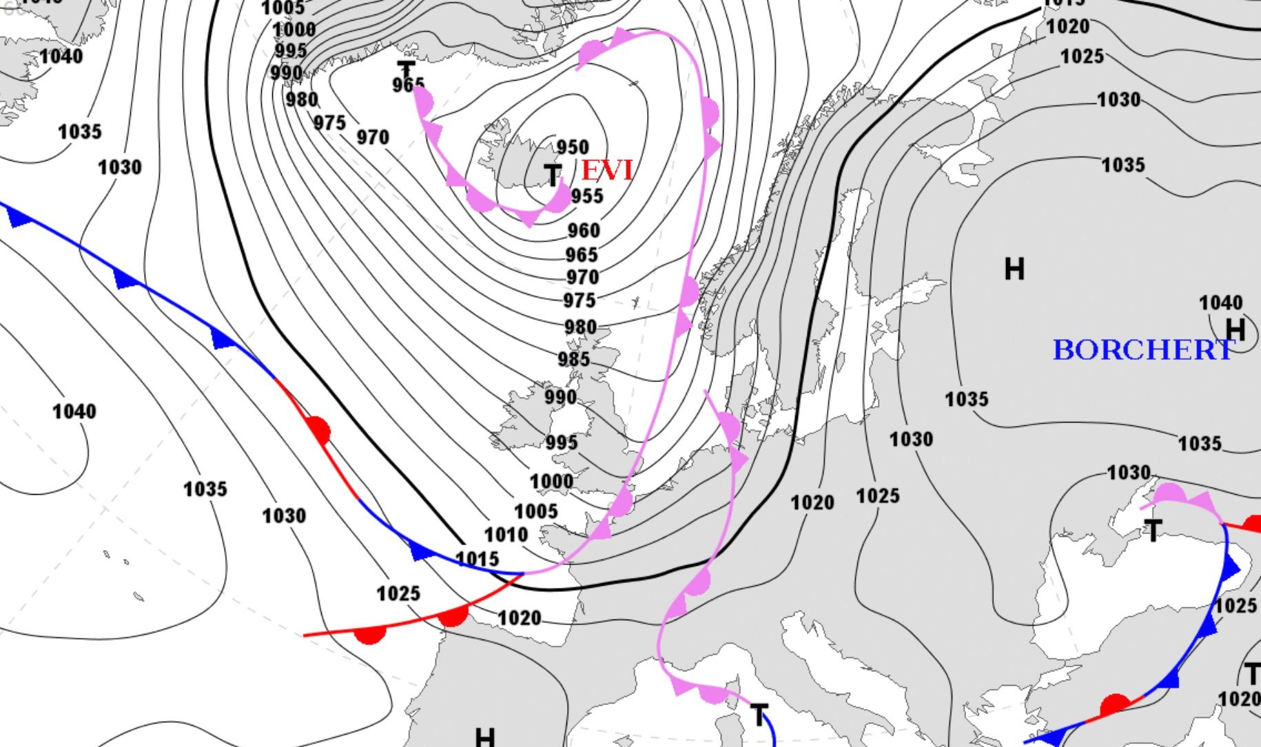
A big storm called Evi will dominate the weather in Europe the next couple of days. You can clearly see how the tight isobars cover large parts of Europe on the map above. It’s a sizable storm with a lot of wind and lots of snow for those ski areas that are in the line of fire. The jet stream is turning west to northwest and that means that the northwest of the Alps is getting hammered.
There’s a Stau in the northwest of the Alps, while on the south side of the main alpine ridge the sun will come out and they’ll have to deal with a Föhn from the northwest.
Set of shifting fronts
The first front arrives in the Alps on Monday afternoon and from that moment on warm and cold fronts alternate. These warm fronts will only be of importance in the pre-Alps. There’s so much cold air in the valleys of the resorts situated in the main alpine ridge that this can’t be moved. The snow line can be found deep into the valleys over there. Right now, it will look like this:
- Incoming front with lots of snow on Monday evening
- Incoming warm front and a rising snow line (between 1200 and 1500 meter) and lots of wind on Tuesday
- Much colder thanks to an incoming cold front and snowfall deep into the valleys on Wednesday
- Turbulent weather on Thursday, lots of wind and a rising snow line
- Colder on Friday and snow deep into the valleys
A lot of snow and a lot of wind
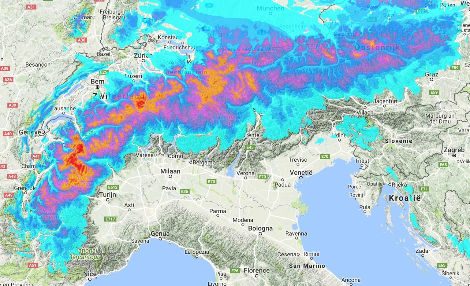
There is a lot of snow in the forecast for the northwest of the Alps. You can expect 50 to 150 cm of fresh snow between Monday and Saturday. An important point of attention is the wind. The wind will be very strong and not just in the northwest of the Alps. Large parts of the Alps will regularly face a stormy wind in the coming week. This can lead to temporarily closed top lifts in a lot of resorts.
wePowder Pro members: thanks for your support!!
We have introduced wePowder Pro this winter. You’ll get extra weather and terrain data for € 25,08 per year (you can not even buy a day pass for that amount in many places). This allows us to further expand our service and we have found a way to express your support to us. Many of the readers of wePowder have done that already and the whole wePowder team and myself are grateful for that. This allows us to keep on developing to make our service even better. Thank you very much!
Are you not a wePowder Pro yet, but do you regularly read the weather forecast or use the services on wePowder? With an upgrade to wePowder Pro you support us, you can express your gratitude and you’ll ride more powder. And it works great for your karma as well. Thanks! Oh, and you’ll get a free 7-day trial when you register yourself on wePowder. No strings attached!
Where and when to go?
The first snow is already coming down in the northwest of the Alps on Monday and Tuesday. I wouldn’t go those days. A warm front with a lot of wind passes on Tuesday and a cold front passes in the night to Wednesday. It will snow deep into the valleys then. You can expect a lot of snow on Wednesday and because it is colder, the situation will be ideal for the better treeruns. The snow line will temporarily rise on Thursday, but even then the tree runs will be good. Friday will be colder with possibly continuous snowfall.
Because of the wind and the large amounts of fresh snow, I wouldn’t ride above the tree line. Go for areas where you can find good riding in the trees (and preferably with lifts between 1400 and 2100 meters) . You can go for the northern French Alps, the west and north of Switzerland and the Austrian Vorarlberg. It is ON in all these areas from Wednesday. Great conditions between the trees and lots of fresh snow.
More details tomorrow!
Stay stoked. Morris
Replies
How will it affect Scotland?
who cares?? lol
So snow is underway, where to go then? Maby I will get the opportunity to fly to Geneva on Friday and stay to Monday. Is Courmayeur or La Thuile good options? The wind and temperatur will be tricky right?
who cares?? lol\
mmp3 op 15 Jan 2018 10:39
quite a large ski industry in Scotland with many jobs at risk, just saying! Oh and me
Hi Morris. First many compliment for you service. for logistic reason I am interested in the central south Alp (Lombarida). What is the best condition to create decent snow fall there? I can see this year most of the south sortm are dominated by Val’daosta and Pedmont
thanks
Hey Morris, quick question…back to our climate theme from last week…
It´s been a few years since I’ve seen snow that’s come directly from the north into Austria, could you explain what needs to happen for these storms to arrive? I remember being in the Dolomites back in January 2012 when BITTERLY cold air came in from Russia but it seems like ages since that’s happened. It snowed very little south of the Alpine Ridge so we made a weekend escape to Ishgl and we were floored by how much snow there was. It just seems to me that the last several years all the storms are coming from a very westerly direction…hence the seesawing temperatures. Thought maybe you could shed some light as you ARE the winter-climate-guru!
Enjoy Canada…my home!
Thomas
@@meteomorris
Hi and thanks for all your great advice!
I am planning the coming trip this weekend, and I wonder how to read the 14-day info about each resort. I also cant help getting more interested in the weather when I read this page.?
Now with fluctuating temperatures, thats one thing I check out in detail, and I noticed that the diagram over freezing level often indicate a different 0-level altitude then the numbers further down the page, and also from your verbal forecast. Which of the Numbers are most reliable and why?? As an example, in the diagram for Verbier it looks like freezing level sun-mon could be as high as 2500 m, but in the table further down it says 1800-1900 meters.
https://cdn.wepowder.com/site/forum/13/98aa9882d348ecf0c35c2932bd93cce4_d7f54552_c3b9_4467_b43f_c53f0b38ccac.png?width=800
Erik Lyttkens