A couple of great powder days come to an end due to an incoming (very active) warm front. Just like I’d skip last Tuesday and Thursday, I would also skip Sunday in the French Alps and Monday in the entire Alps. The snow cover is very unstable during the next 36 to 72 hours. The wind will be very strong for the next 24 hours, and you can expect a lot of snow the next 24 hours (that will come down as rain below 1700-2000 meters). This will result in an unstable snow cover. The weather in the Alps will calm down after Tuesday and you can possibly expect a new storm by the end of the week. In this forecast:
- Very active warm front on its way
- HIGH avalanche danger
- Sunday and Monday are a NO GO!
- The weather will calm down from Tuesday
- New storm by the end of the week
Very active warm front on its way
A very active front is moving into the Alps on Sunday. It’s a front with lots of wind and a lot of precipitation. The snow line can be found deep in the valleys at first, but will rise to 2000 meters in the west and 1500 meters in the east in the night to Monday and on Monday itself. It might rise even higher during the day.
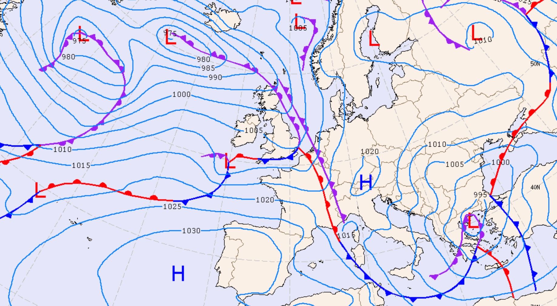
The incoming front is clearly visible on the map above. It is the red line that runs from The Netherlands towards the French Alps. This front will slowly move into the Alps in the coming hours. It is the worst situation you could wish for as a freerider. The temperature will rise rapidly below the tree line on Sunday. It will snow at first, but don’t be fooled. The rapidly rising temperature results in a heavy snow cover. There is still a nasty layer in the snow cover that will cause problems due to the rising temperatures. In addition, rain and wet snow will also destabilize the snow cover up to about 2200 meters. And above 2000 meters, the large amounts of fresh snow in combination with wind will ensure spontaneous avalanches. It’s a very explosive situation.
HIGH avalanche danger
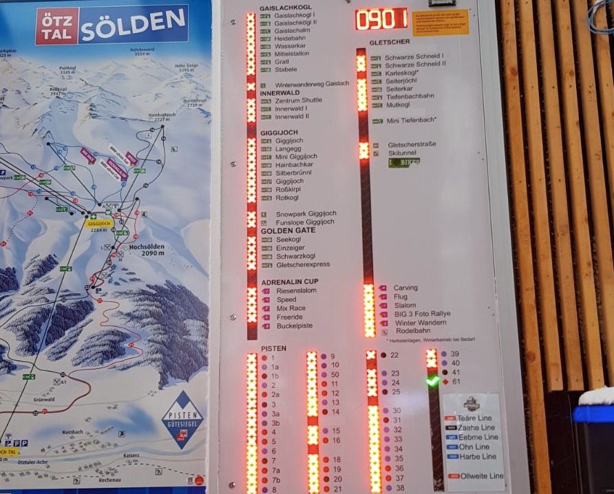
Lots of fresh snow, fluctuating temperatures and a lot of wind is a cocktail that guarantees a rising avalanche danger. There’s also the problem of surface hoar in the Alps and top layers that don’t bond well. All conditions for a very tricky situation are present. The avalanche danger in parts of the French Alps, Switzerland and Austria is already HIGH. Sölden was closed this morning due to the high avalanche danger. The roads to resorts like Gargellen, Zermatt, Arc 2000, Le Fornet en Hochfügen are already closed. There is a chance that the avalanche danger rises to EXTREME (5 on a scale of 5) in Switzerland from Sunday afternoon. That is very, very exceptional and emphasizes the extreme nature of the situation. You can check the current avalanche danger at each ski resort on wePowder. If you want a quick overview of the situation in the Alps, click here.
Sunday and Monday are a NO GO!
We seldom give a NO GO at wePowder because we believe that everyone is responsible for their own actions in the backcountry and there are always situations where experts can find a good solution. Due to the extreme nature of the situation, we are giving an explicit NO GO for the first time in our history. The snow cover will become that unstable in large parts of the Alps in the coming hours that it will be really dangerous. There will be a lot of spontaneous avalanches the next 48 hours and we strongly advise you not to ride off-piste.
The weather will calm down from Tuesday
There is a weak cold front coming in on Tuesday which brings a temporarily drop in temperature. After that, high pressure takes over and milder air flows into the Alps. The days will be sunny but mild, the nights cold and clear. Especially the cold nights will stabilize the snow cover, since the sun still has little influence on steeper western, northern and eastern faces during the day. I hope to give you a idea where you can find some powder later in the week on Monday/Tuesday. First wait for the effects of the incoming storm.
New storm by the end of the week
A new storm will come in at the end of week. The impact and duration are still uncertain. For the time being, there is a temporary drop in temperature that may result in powder days on Saturday/Sunday in the northwest of the Alps. More details about that later this week.
wePowder Pro members: thanks for your support!!
We have introduced wePowder Pro this winter. You’ll get extra weather and terrain data for € 25,08 per year (you can not even buy a day pass for that amount in many places). This allows us to further expand our service and we have found a way to express your support to us. Many of the readers of wePowder have done that already and the whole wePowder team and myself are grateful for that. This allows us to keep on developing to make our service even better. Thank you very much!
Are you not a wePowder Pro yet, but do you regularly read the weather forecast or use the services on wePowder? With an upgrade to wePowder Pro you support us, you can express your gratitude and you’ll ride more powder. And it works great for your karma as well. Thanks! Oh, and you’ll get a free 7-day trial when you register yourself on wePowder. No strings attached!
Stay stoked,
Morris
Replies
Well drat. Engelberg was fun today in a howler whiteout. Good snow. Plan to ski eberg tomorrow then off to Andermatt where madness is planned.
Only the lower tram was open on Gemstock in Andermatt on Sunday. The new Gondola did not ipen on Sunday at all so if it opens Monday, it will be completely untouched and skis right down to the village. Guessing Gemstock still will not be open to the top and locals hit lower tram hard yesterday. Have fun!
Les 2 alpes sere funny Yesterday, although only under 2400 was open. All types od snow se found :) but cracky noise under top od valle blanche was very unpleasant
no go no go… :) sunday 21st in Vallèe, crazy “one leg” Mattia riding 1 m. of sugar