We have been living in 2020 for almost two weeks and all without a powder alert. The last powder alert dates from December 29th, 2019 and the last significant snow fell in the first week of January in the Austrian Alps. Since then it has been mild, dry and very sunny. As a result, it is becoming increasingly difficult to find untracked powder and a some stormy conditons are more than welcome. High pressure has been dominating the weather for weeks, but there is some light at the end of the Tunnel. At least one and maybe two storms are tracking towards the Alps. But is it enough for a powder alert? And what will happen afterwards? In this article:
- sunny and mild weather persists until Thursday
- Friday-Saturday-Sunday: finally a new storm
- How much snow will fall? Where to go
- Long term: will high pressure be dominant again?
Sunny and mild weather persists until Thursday
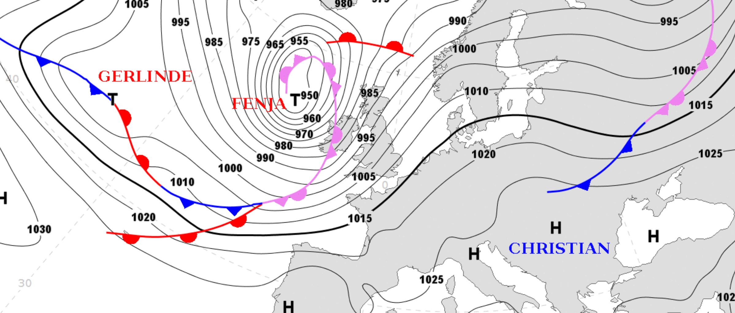
The map above shows an enormous storm high on the Atlantic, but the Alps will not get much from that storm. Sunny and mild weather persists until Thursday, because high pressure determines the weather in the Alps. It is therefore sunny, too mild and way to dry. Anyone looking at the Alps from space in the coming days will probably see the Alps just like you see it on the image below. It is possible that the valleys will fill here and there with some fog, but higher up the mountain the sun dominates.
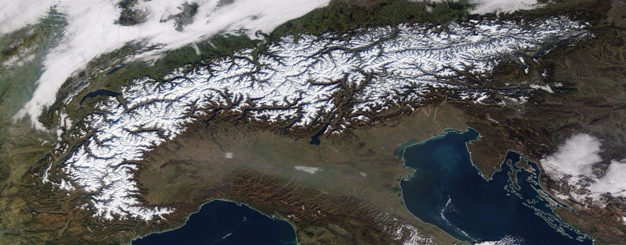
The photo above is from NASA and via this link you can check some actuel images yourself. Look around a bit and you will probably also see that the Pyrenees and the Abruzzo are lacking snow and that winter has not really started there yet.
Friday-Saturday-Sunday: finally a new storm
A new storm will finally find its way to the Alps. Fresh snow will fall from Friday till Sunday with a considerable temperature drop. But the key question is still: how much snow will fall and what will be the sweet spot? In the past 72 hours I have seen all sorts of model output passing by and the most recent runs still cause question marks. It is striking that no model currently has a consistent line in their output. Some examples:
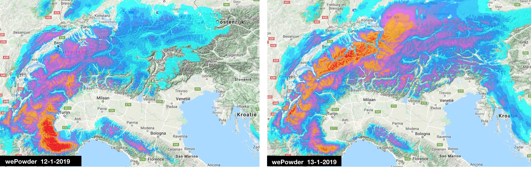
First the wePowder model. Because it uses a very fine grid, the details are clearly visible. In the run of Sunday there seemed to be a retour d’est, in the run of Monday the west-northwest picks up most of the snow.
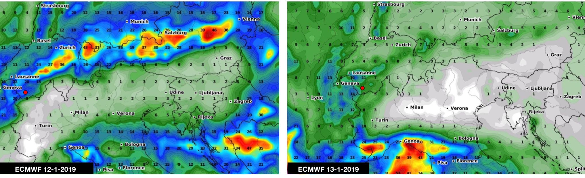
Then the European model (ECMWF). A less fine grid, therefore fewer details. Precipitation in mm and not converted to centimeters snow as in the wePowder model (which also takes wind and temperature into account when converting from mm to cm of snow).
In the run of Sunday snow for the north, in the run of Monday a retour d’est.
Finally the American model (GFS). There too, a less fine grid and precipitation in mm. The GFS model is in favor of snow for the northwest and north side of the Apennines.
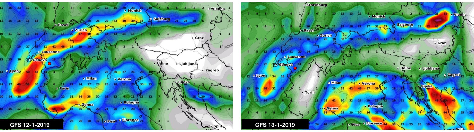
Conclusion: it can still go either way. That a storm will follow, that it will be colder and that snow will follow, can now be said with certainty. But where you want to be when the upcoming storm is far from saying. In short, hold your horses. And again when the snow starts falling, a warning is in place:
Fresh snow is on its and this will surely cause a lot of powder pabic. But fresh snow on an old snow layer also guarantees problems. In case of new snow, take a rapidly rising avalanche danger into account. To prepare yourself already, it might be a good idea to refresh your knowledge with our Mountain Academy.
Long term: will high pressure be dominant again?
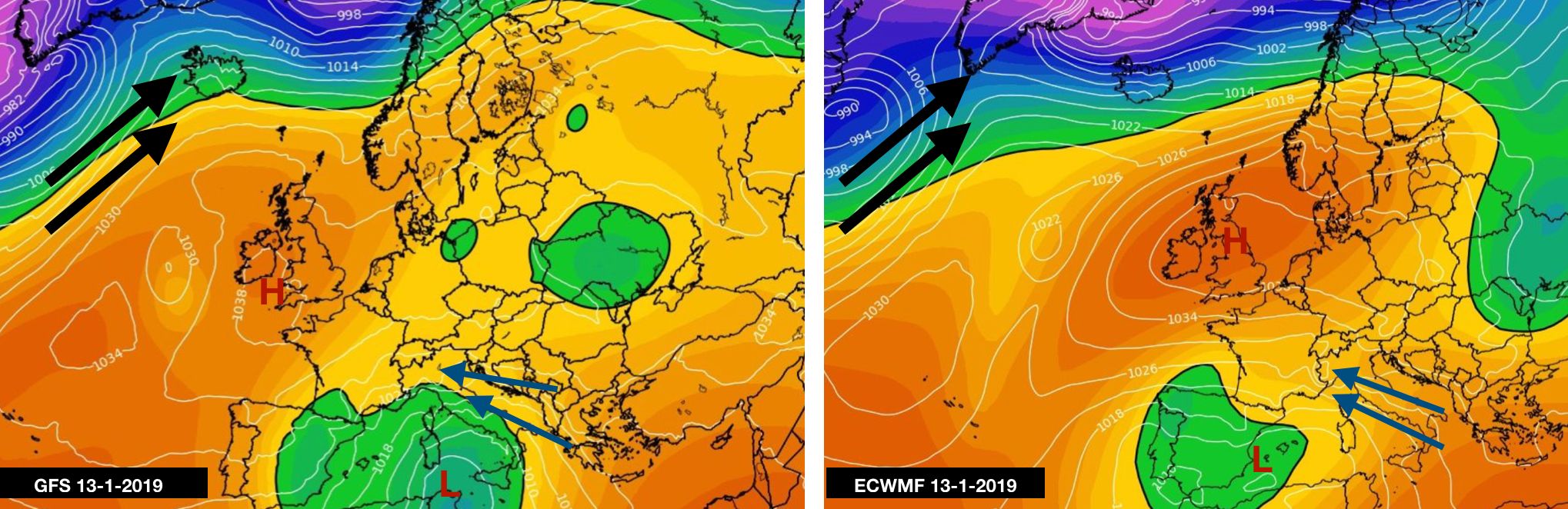
Although the models change places where it will snow next weekend, they seem fairly unanimous about the long term. After the weekend, high pressure would again lie above the British Isles. With this, storms will need to follow a large arc (see the black arrows) and are directed towards the north of Europe.
But in the same time, a storm has managed to slip through and it os expected above the Mediterranean Sea. In such a scenario, the upper air flow in the Alps turns to the east so that the humid and unstable air of the storm starts to mix with cold continental air. In such a case you may expect a lot of snow for the Italian Piedmont. This should then take place between Monday the 20th and Thursday the 23rd of January. Still very far away, but a nice scenario to dream away with.
Provisional conclusions:
- mild and sunny until Thursday
- a storm from Friday but the location and amount of snow is still guessing (PA # 7?)
- please note: increased avalanche risk
- long term: will the supply of storms for western and northern Alps be cut off?
- long term: does that storm in the Mediterranean offer hope? (PA # 8)
Tomorrow we will continue to puzzle.
Last but not least, I want to ask you to read and where possible support Erik Bulckens’ dream. Erik Bulckens is a cinematographer, documentary maker and powder fanatic. Thanks to wePowder, he has been scoring powder for years. His dream is to make a movie documentary about the people behind wePowder. For that, Erik needs your help. You can read all about it here: read here. Do you help Erik make his dream come true? Thank you very much for your help!
Morris
Replies
We’re in Verbier right now and it needs no saying that any off-piste (even touring) is pretty much zero. I can’t remember the last time the models have been so inconclusive especially so near-term. This is in itself is quite phenomenal and worthy of study. Anyway, the pistes are all in pretty good conditions for those who like that but for those waiting for powder, it sure is nerve-wrecking…?
T.
Hi Morris,
We are arriving at Geneva airport on Saturday the 18th of January, where do you recommend that we go?
Regards Fredrik
I love how the snow in the forecast gently avoids Sankt Anton an Ischgl - it should snow westwards on Saturday and eastwards on Sunday. One could say it’s uncertain, but I am pretty sure this will be perfectly correct, as I am gonna be there :)
@@Fredrik: never fly for skiing
@@funrise2000 Always good to look after your carbon footprint and make people aware. I assume you don’t eat meat before, after and during skiing?
@@funrise2000 Will anyone give me odds on my thinking that @@funrise2000 does not have to cross international borders to get to the mountains…?
where do you get your weather system names from?
the british and irish (and it seems the dutch now too) weather services have an alphabet of names for storms this year here: