The next 3 days lots and lots and lots and lots of snow is expected for the southern part of the Alps. Too bad we cannot directly benefit from this big dump, but it will be the perfect base for the rest of the season, especially for the Southern Alps. The northern Alps will benefit as well and there’s even more snow on its way next week.
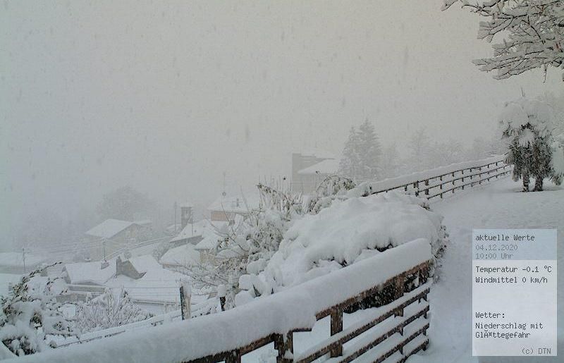
It’s already snowing in a lot of regions in the southern Alps. Check out this picture from Ticino at 600 meters altitude!
Polar air coming in
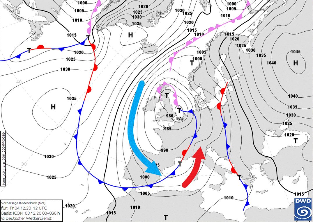
If we look at the large scale weather chart we can clearly see a strong cyclonic flow as a result of the low pressure system over Great-Britain. To the west of this low pressure centre, polar air masses are transported all the way down to the Iberian Peninsula. Today, a small low pressure core tries to move to the south towards the Western-Mediterranean, which creates a strong southerly flow for the Alps. This flow, ahead of the cold front, will transport lots of moisture from the Mediterranean Sea towards the Alps and will result in an excessive precipitation event in the southern part of the Alps.
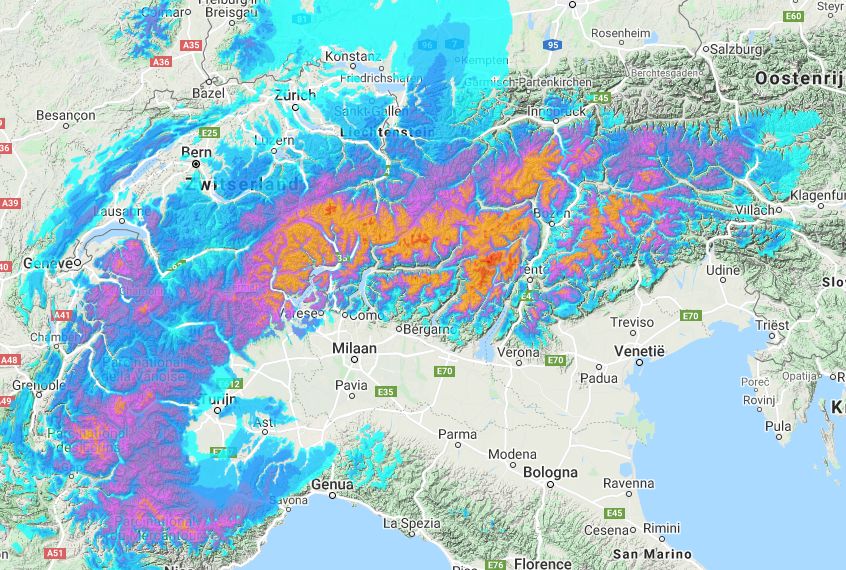
First of all, at the moment the Southern French Alps and Southern Piedmont will receive a substantial amount of snow above 1200 meters, possibly up to 50 centimeters in the higher regions in the Écrins and Alpes-Maritimes. During the course of the day the precipitation will also reach further east and will quickly cover the whole Southern Alps under a thick blanket of snow.
On a large scale, from Ticino to Carinthia, more than 1 meter of fresh snow is expected this weekend, but the hotspots of the snowfall will be the Dolomites, East-Tyrol and the Hohe Tauern. It’s very likely that we’re gonna see a total accumulation of up to 2 meters of snow in these regions by Sunday evening. It’s important to mention that this snowfall will occur in a warm sector ahead of the cold front. We therefore have to consider a rising snow line, which can reach 1500 meters. However, the snow line won’t be very constant during this heavy snowfall event. This is due to the fact that it strongly depends on the intensity of the precipitation and the leftover cold pools in valleys. Especially in the inner alpine valleys these cold pools can persist for a very long time, even with the inflow of warmer air higher up. In the inner alpine regions of South-Tyrol, East-Tyrol, Carinthia and the Dolomites it can snow surprisingly long into the valleys, but the snow will get wetter during the course of Saturday and Sunday.
Lots of difficulties
These amounts of fresh snow can be a serious threat to these regions. Especially Saturday during the intense peak of the snowfall we can expect lots of problems. Think of the inaccessibility of remote villages, power outages, land slides and the rapid increase of avalanche danger. On top of that, strong winds will further increase these risks. The weather services of Italy and Austria have already issued a warning for this severe weather situation.
Föhn in Austria on Friday
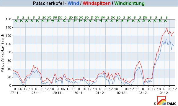
The Northern Alps, in particular Austria, will experience a strong föhn event today. Wind gusts will exceed 120 kilometers per hour at crest height and also typical föhn corridors like Innsbruck and Gastein will be hit by the Südföhn. Last night, Patscherkofel already measured a wind gust of almost 140 km/h.
Snowfall in parts of the northern Alps during the weekend
^The forecasts on wePowder are powdered by our friends at Ortovox
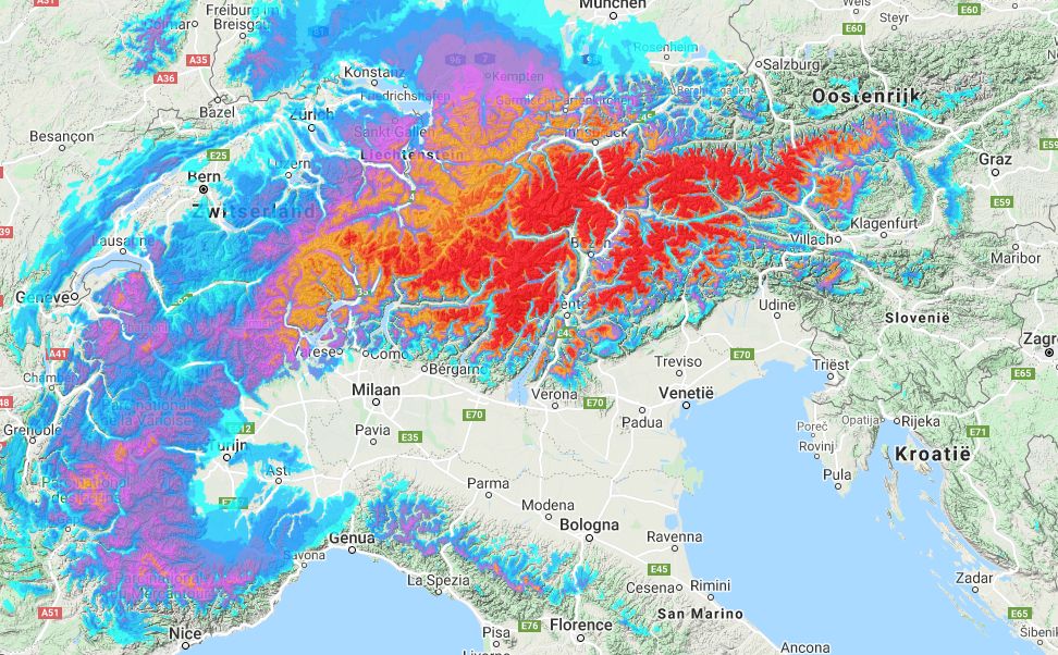
Tomorrow also the Northern Alps of Austria will deal with snowfall. The föhn effect won’t be completely gone, but will be restricted to the east of Austria. Especially the areas close to the main alpine ridge (Zillertal Alps, Ötztal Alps, etc) will receive up to 1 meter of fresh snow (or even more). Further north the amount of snowfall will rapidly decrease. Also on the north side of the Alps the snow line can strongly vary between different locations and during the day. With high winds it can locally and temporary rain up to 1500 meters, but during calm conditions and strong precipitation it can snow into the lowest valleys.
Long term
During the days after the massive snowfall, low pressure systems keep following this track towards the Mediterranean Sea and will probably deliver even more snow for the southern Alps on Tuesday and Wednesday, but it won’t be even close to the massive amounts of this weekend.

wePowder guide can be ordered again!
We can’t travel to the Alps, winter is still coming, but the preparation can already start! Whatever it will look like, the wePowder Guide is available again in the pre-order. For € 45.00 (excl. shipping) this thick book of 400+ pages will be delivered to you mid-December! Thanks for your support!