After a first Retour d’Est for Piemonte, the second one is already on the weather charts! This one will be more interesting, because areas above 2000 metres might receive a metre of snow! Check the staggering amounts per area in our forecast. Before we get too excited, let’s take a look and see if all the weather models agree with these big snow amounts.
In this weather forecast:
- Looking back at the first Retour d’Est
- Very warm in the Northern Alps
- Snowfall in the weekend
- Another Retour d’Est
First Retour d’Est
^The forecasts on wePowder are powdered by our friends at Ortovox
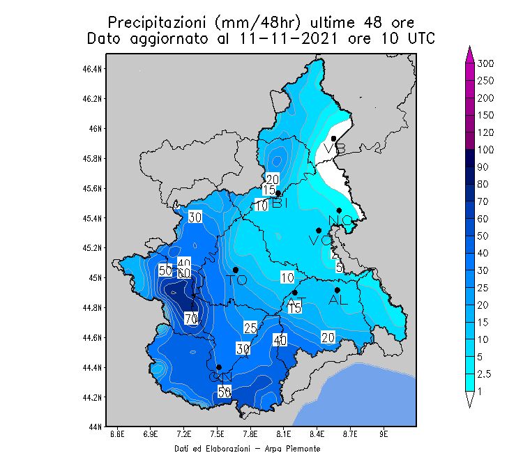
What did the first Retour d’Est in Piemonte bring? A lot of precipitation as you can see on the map with up to 70mm in the Cottian Alps. As expected the snowline was quite high, so areas below 2000 metres haven’t been able to profit from this snowfall yet.

")
")
Warm in the Northern Alps
It has been very warm in the Northern Alps for a few days now, with frost-free nights well above 2000 metres. The calm high-pressure conditions create inversion weather and thus Hochnebel. This results in beautiful webcams and satellite images. Above the inversion it is very mild. The temperature on the Hahnenkamm near Kitzbühel at almost 1800 metres has not dropped below 7 degrees for three days. In some valleys, the temperature has risen to 18 degrees Celsius in recent days. On the southern slopes in particular, the snow is disappearing fast. Even today, it remains very mild, especially in the Northern Alps, with the zero degree line well above 3000 metres.
")
")
Frontal passage
In the course of tomorrow afternoon, a low-pressure area with a front will approach from the northwest. The core will move from north to south over the Alps, which means that there will be no long stau-precipitation. Between Central Switzerland and Tyrol, about 10 centimetres of snow may fall with an initial snowline of 1800 metres. Eventually, it may snow above 1300 metres. Areas around the Alpine main ridge will receive more snow, possibly up to 20 to 30 centimetres.
The southern Alps will receive more snow on Sunday, although the model calculations differ widely. ECMWF predicts more snow in Lombardy, while GFS predicts more snow in the Dolomites. ICON takes the opposite path of the European model and shows the Dolomites as the main beneficiaries of the snowfall. Tomorrow we’ll post a short update in the comments.

")
Another Retour d’Est
After this snowfall, it’s Piedmont’s turn again. After we already had the first Retour d’Est of the season in the middle of this week (which came as quite a surprise), the weather models immediately announced the next Retour d’Est. From Sunday evening onwards, the depression over the Gulf of Genoa will make sure the wind comes from the east again and that a lot of moist air will hit the Piedmont Alps. The snowfall can last until Tuesday morning. Also some French areas like the Queyras and Tignes - Val d’Isère will benefit, but with a Retour d’Est you should always consider the fact that the snow amounts will decrease strongly with every kilometre to the west.
This time it also seems to stay a bit colder, which means that areas above 2000 metres can at least receive a great base for the season. During the heavy snowfall, the snowline can stay at around 1500 metres for a long time. In Northern Piedmont, the snowline will be slightly higher though. But what will it bring? Do all models agree on that meter of snow? We’ll take another look at some weather models to get a better idea of the snow distribution:
- GFS:
up to 100 cm. The area with the heaviest snowfall has shifted further north in recent runs, so now also in Monterosa Ski, Zermatt and Saas-Fee. - ECMWF:
Up to 80 cm especially for the Cottian Alps. The amounts are slightly reduced compared to the previous run. - ICON:
Up to 1.5 metres of snow in the new run. Increasing amounts in the last runs. Focus for the Cottian Alps. - ARPEGE:
From Alpi Marittime to Monte Rosa 1 metre possible, while yesterday hardly any was expected for Northern Piemonte.
So there is a lot of snow coming, but a metre of snow might me a bit optimistic according to some models. The snowfall has been well planned for several days in several models, so I’m hopeful that a lot of snow will come down, especially for the Cottian Alps. I think we can expect some enviable images from Rogier in the coming days with this snowfall. Tomorrow a short update in the comments below!
Replies
The snowfall in the Central Alps tonight and tomorrow has shifted a bit to the east, which means the Dolomites can now also benefit a bit more from this snowfall. Most models indicate about 20 to 40 centimetres of snow. For the Retour d’Est from tomorrow afternoon, the European model adjusted the amounts upwards again with up to 1 meter of snow possible. Also the American model predicts these amounts. ICON still produces the most positive model outputs with amounts up to 150 centimetres. In all models these amounts don’t seem to be possible anymore in the northern areas of Piedmont, but in areas like Monterosa Ski more than half a meter of snow is still possible.