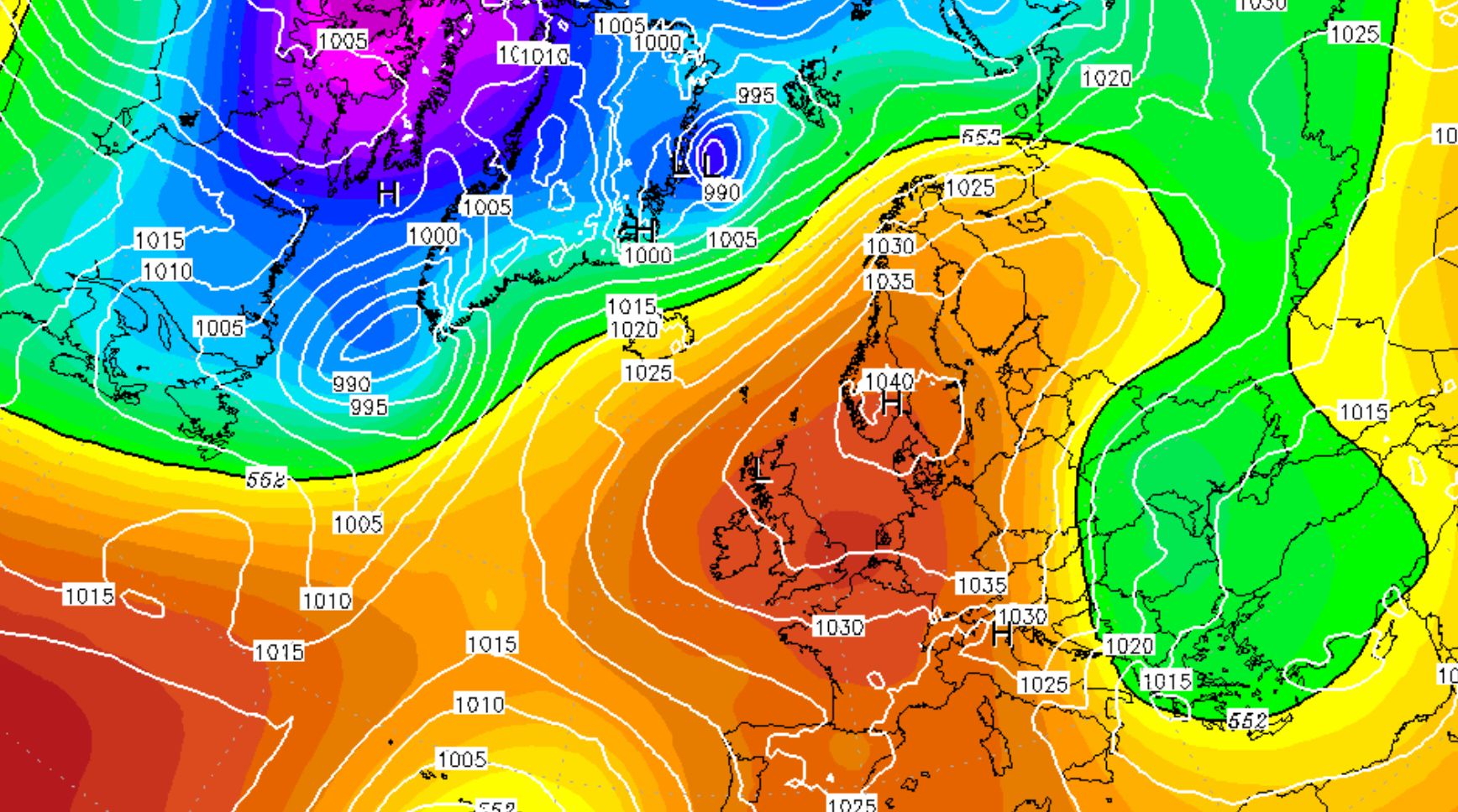
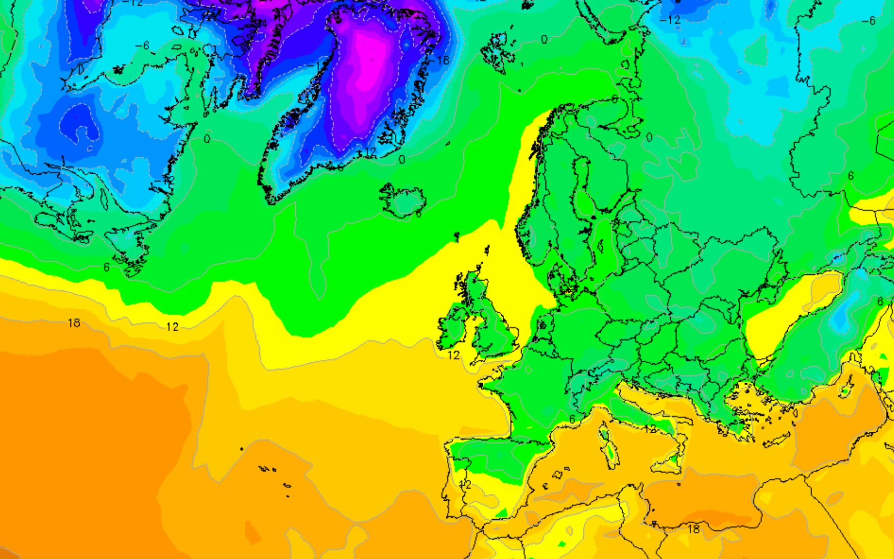
I can imagine that they are quite fed up with all the storms in Italy and that they yearn for some drier and more stable weather. But when you look at it from the perspective of a skier or snowboarder the forecast doesn’t look that good. According to the latest calculations, high pressure becomes dominant. This produces a mild and dry current from the south at first, but the temperature will drop when the current turns to the east later. I am not excited for two reasons:
- There’s no significant precipitation in the forecast
- Clear nights provide a transforming snow cover that can serve as a basis for future avalanches
It is expected that this situation can last for one or maybe even two weeks or longer. The jet stream is forced to make a big detour around the Alps, causing storm depressions to be set at a distance. Such blockages due to high pressure can sometimes last for weeks. It is true that at the beginning of this week a weak front is still gently touching the Alps, but after that it looks a lot like the pressure formation that was responsible for the heat wave and drought in large parts of Europe during the last summer.
Great start for the high alpine
As I mentioned, people in large parts of southern Europe will be happy with the stable weather that’s coming up. After two weeks of intense rain, wind and a lot of snow for the high alpine they deserve some stable weather after all the damages the storm has done. Fortunately, the succession of storm depressions also brought some good news. There’s a good base south of the main alpine ridge and in the main alpine ridge.
A lot os snow came down around the Mont Viso, on the border of France and Italy. You can even go out around Sestrière already.
The glacier resorts in the rest of the Alps also got a lot of of snow, particularly the ones on the border between Italy and Switzerland. The snow cover is more than thick enough to go for a tour above 2200-2400 meters. You can also enjoy the glaciers. For a nice comparison between the north and south of the Alps: check this article.
Bad news comes twice: no significant precipitation
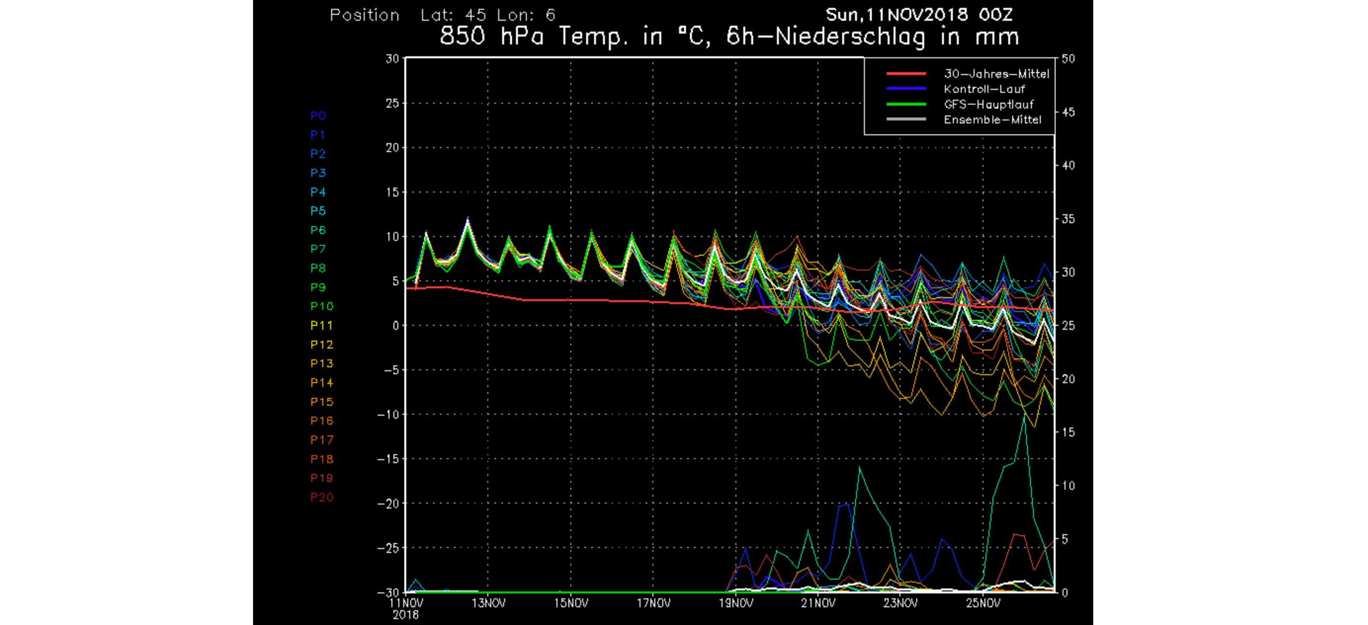
The most important models calculate some clouds and precipitation for the beginning of this week, but an extensive high pressure area becomes dominant from the middle of this week. It seems that this high pressure area is so strong that it will keep precipitation far from the Alps in the coming period. That is bad news and, according to scientists, fits within a change that we have seen for some time. As a result of climate change, we have seen more and more blockades lately in the weather patterns, which forces the jetstream to make a detour. Because the blockade in the current calculations is right above the Alps, we are unlucky.
No precipitation means no snow, and that in a month where we like to see the base for the rest of the winter come down.
Bad news comes twice: clear nights
A second problem of a long period of high pressure are the blue skies. Although the graph above shows that the coming period is too warm for the time of the year, the problem is the following. The nights will be clear, the sun is already low and there’s only a snow cover above 2200-2400 meters in the main alpine ridge and south of it. The result is that it cools down during the nights and even in and it will be below zero degrees above the snow cover in many places during the day. We then have to deal with the snow cover losing its moisture and the formation of surface hoar. That will not be a problem for now, but the longer this persists, the greater that part of the snow cover that transforms into cohesion-free crystals. This will become the weak layer with new snowfall. Exactly the problem with which we were confronted in the winter of 14-15 and that resulted in dozens of fatalities. 68 people lost their lives as a result of avalanches in a short time.
Let’s hope that the models are not right and that the first signs of coming storms on the weather maps will be available next week.
It gets colder: artificial snow as a solution?
What the graph above shows is that dropping temperatures are calculated for the long term. Where the Alps first have to do with a southern current, the current could become eastern with the supply of colder air as a result in the distant future.
The artificial snow machines can be used with the dropping temperatures. It was the salvation of the winters 14-15, 15-16 and 16-17. The snow only came down during or even after Christmas in many places in those winters. With this scenario in mind, many ski resorts will want to start producing artificial snow. A lot of skiers and snowboarders will be happy with the results, but it’s not that good for nature. It was one of the driest and warmest summers particularly in the west and north of the Alps (at least since they started measuring). A lot of water is needed for artificial snow. Water that is now being extracted and stored in artificial lakes. What the solution is for the local economy is a drama for local flora and fauna.
One way or another: let’s hope for a good storm that will bring a lot of snow!
Stay stoked
Morris
Replies
Hey Morris!
While we all eagerly wait for some snowflakes and given your saavy sage-like ways of calling the weather, could you give us an idea of what were the catalysts for last year’s awesome November snowfalls. Since we’re all twindling our thumbs waiting for snow maybe sone nice memories of last early season will help to cheer us up. That, and cuz it’s interesting to know as well… thanks, bro! T.
Hi Morris, i think the weather setup is starting to change and starts looking promising after 20th Nov ?
@@thomasweller, last year we were right in the track of and endless that jetstream forced storm after storm into the Alps. I will write a more extended article about then and now… @@AxelK, you might be right. Check my most recent update: https://wepowder.com/en/forum/topic/260545