
- 1cm
- 5cm
- 10cm
- 15cm
- 20cm
- 30cm
- 40cm
- 50cm
- 75cm
- 100+
- 1mm
- 5mm
- 10mm
- 20mm
- 30mm
- 60mm
- 120+
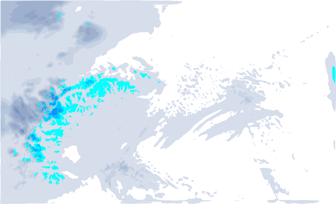
It’s nice waking up like this! Not much has fallen yet, but over the next few hours it will continue to snow solidly on the northern side, which could possibly see up to half a metre of snow locally.


Stormy night
A small low pressure area moved eastward from northern France over southern Germany and on towards Austria last night. This was accompanied by a considerable wind field last night. Not only higher up, we saw stormy winds, but also into the valleys and the northern Alpine foreland. Strong wind gusts were already measured last night, but last night it went completely wild with wind gusts of as much as 171 kilometres per hour on the Säntis.
| Weather station | Max wind gust |
|---|---|
| Säntis | 171 km/h |
| Titlis - Engelberg | 148 km/h |
| Feuerkogel | 130 km/h |
| Zugspitze | 130 km/h |
| Ischgl Idalpe | 110 km/h |
| Valluga - St. Anton | 109 km/h |
| Galzig - St. Anton | 109 km/h |
At the back of this low pressure core, the wind turned from west to northwest and moist and cold air masses are now slapped on the Northern Alps. The wind also decreases a little at the same time.

Today also snow during the day
Today, snowfall in the northern and north-western Alps will continue for longer. The strongest snowfall will be between central Switzerland and the Arlberg, where 20 to 40 centimetres may fall. In these typical north-western Staulagen (Glarus Alps, Arlberg), half a metre of snow could fall until Saturday morning. It remains nice and fresh, keeping the snowline around 800 to 1,000 metres. At the alpine edge (e.g. the Allgäu), the snowline could also go a bit lower.


High pressure
Under the influence of a high-pressure system to the west of the Alps, Saturday will remain largely dry. In the morning, we do see some remnants of snowfall in eastern Austria. During the afternoon, an offshoot of a warm front moves across the Alps from the west. In the French Northern Alps, Valais and the Bernese Oberland, some precipitation may also fall in the process, although it will not be much. The snowline will rise to around 2,000 metres due to rising temperatures.
Sunday mild
On Sunday, the Alps will be in the warm sector and so the day will be fairly mild. During the morning, a precipitation area approaches the northern Alps. Snow will only fall above 2,000 to 2,300 metres, in Switzerland possibly a bit higher temporarily as the precipitation moves in. Above that, some 5 to 15 centimetres of snow may fall.
.png)
Still changeable at first - then new high-pressure influence?
With a new low-pressure complex to the north of the Alps, the north side will continue to be changeable at first in the coming week, although its course is still far from certain. From Wednesday onwards, the Alps seem to move into calmer waters due to increasing high-pressure influence from the west. The jet stream is a lot more northerly and pretty much perpendicular to Norway, possibly bringing large amounts of snow for the western parts there.