On Wednesday, in the first PowderAlert of the new winter season, I already wrote extensively about the upcoming November-Nordstau. Haven’t read it yet? Then check here first. In this forecast, I’ll write a short update with some additional info, the small changes in the models since Wednesday and a brief look ahead to early next week.
Are you heading out? Don’t forget to post some live footage here and use #wepowder on Insta!
First snowfall arrived
The cold front entered the Alps from the north during the afternoon. The snowline is currently (Friday 17:00h) already dropping below 1,000 metres at the alpine northern edge and will drop further into the lowest valleys during the evening and night.
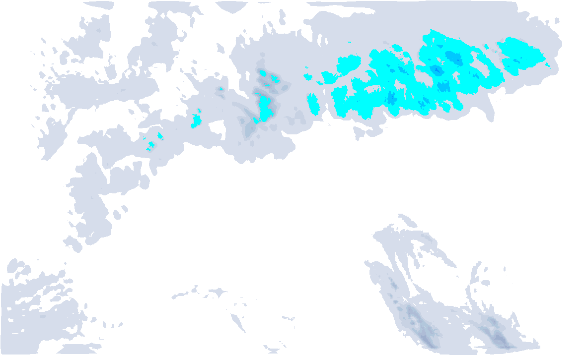
Tomorrow morning, the first layer of fresh snow is already served, but the larger amounts during Saturday into Sunday morning. For that, check our snow map below to see the expected accumulation per 3-hour interval. The amounts have been slightly revised downwards over the past two days, but it’s still more than enough for a first PA in November! On a large scale, 30 to 50 centimetres of snow will fall, with 60 to 90 centimetres in the real Northstau areas. Locally, one metre of snow can still be reached. I still expect the largest amounts falling in the Glarus Alps, Arlberg and the Stau regions in Salzburgerland.
Strong northwesterly
Until Saturday evening, the northwesterly flow will remain very strong. Currently (Friday stand 16:00h) we already see wind speeds of around 90 to 100 kilometres per hour at the measuring stations on the peaks of the Jungfraujoch, Gütsch (Andermatt), Säntis, Valluga (Arlberg), Brunnenkogel (Pitztal). On the Sonnblick in the Hohe Tauern with 116 kilometres per hour, wind gusts were already very strong.
Not only do the large amounts of fresh snow pose an avalanche risk, but due to the strong northwestly wind, wind slabs will also play a role. Please be aware of that!
Visibility will be pretty lousy, especially on Saturday in the Nordstau areas. In the real inner-alpine areas it could possibly be a bit better on Saturday afternoon in terms of visibility, but stormy winds and closed lifts should be taken into account here! Sunday starts the day heavily cloudy in many places with the remnants of the Nordstau. The wind decreases and, during the afternoon, it may clear up slightly in more and more places.
After the weekend
After the weekend, the changeable weather pattern continues and we can expect even more snow. On Monday, a low pressure core moves over the Benelux countries towards the Alps. Before the core reaches the Alps, a temporary southföhn setting may make it a little milder on the north side, but during Monday afternoon the first snowfall will reach the north-west Alps. During the night from Monday to Tuesday, it is mainly in this corner of the Alps (from the Écrins to the Arlberg) where a substantial amount of snow will fall. In the course of Tuesday, the highest intensities of the snowfall move more towards the Northern Alps. From the French Northern Alps to the Arlberg, some 20 to 50 centimetres could fall with a snowline that will dip below 1,000 metres on Monday. East of Arlberg, it seems to stay at 10 to 20 centimetres for now. At the same time, the southern Alps will have to be patient. It is possible that it will also be their turn later next week.
.jpg)
Wednesday clears widely due to increasing high-pressure influence, but on Thursday the next depression could approach the Alps. Details are really still too uncertain, especially about the snowfall amounts and distribution, but the depression also seems to be accompanied by föhn in the Northern Alps at first. More on this in a new forecast on Monday!


