
The warm and wet westcirculation changes to a northwesterly flow, with colder air providing a lower snowline. A Nordstau will develop where nice amounts could start falling through Friday. PA#4 is going to make up a lot for the northern side!
In this weather report:
- Mild and rainy phase is over
- More snow on the way
- How much will it bring?
- Regional high avalanche danger currently
- Sunny weekend, but milder
Mild and rainy phase is over
The mild phase with the large amounts of rain due to the atmospheric river from the west is over, so it’s time to take stock of the damage to the snow.
Northwest Alps
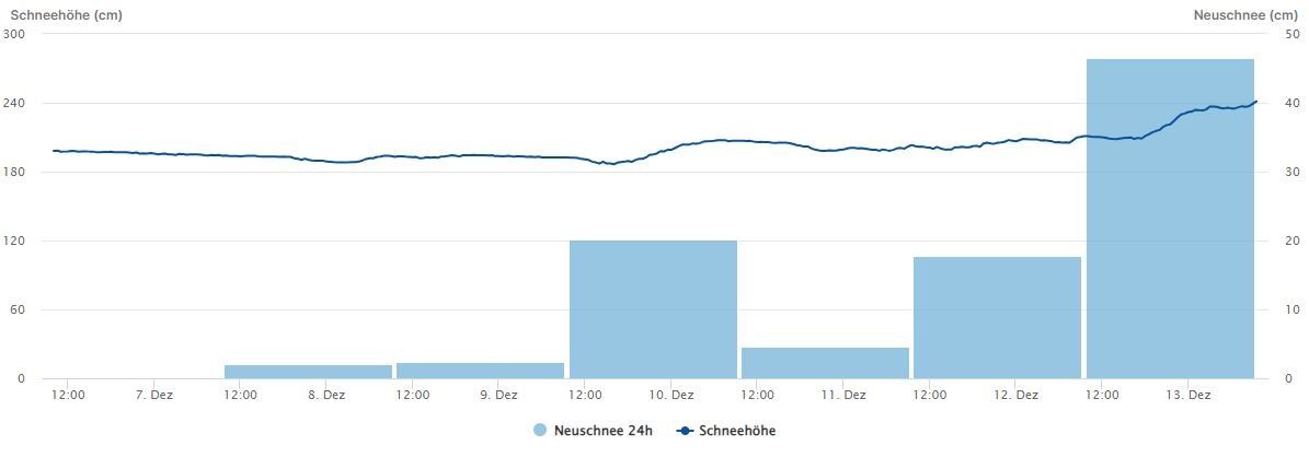
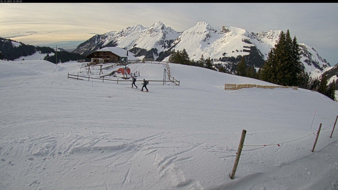
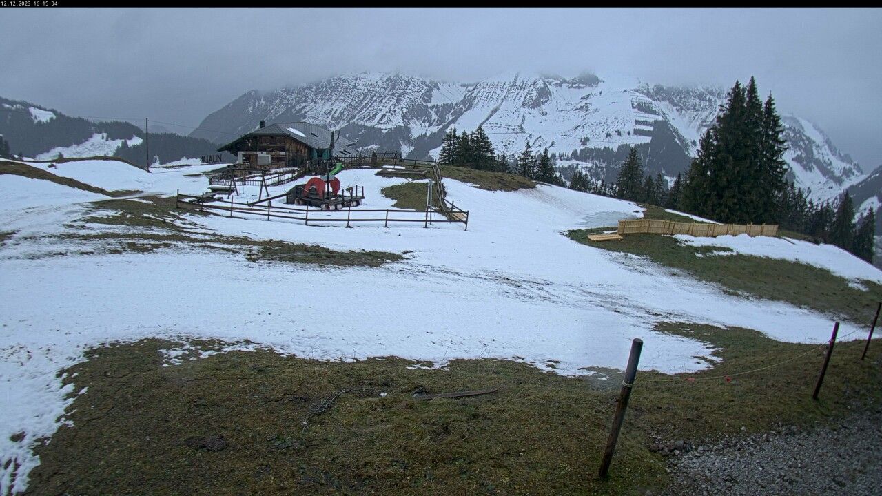
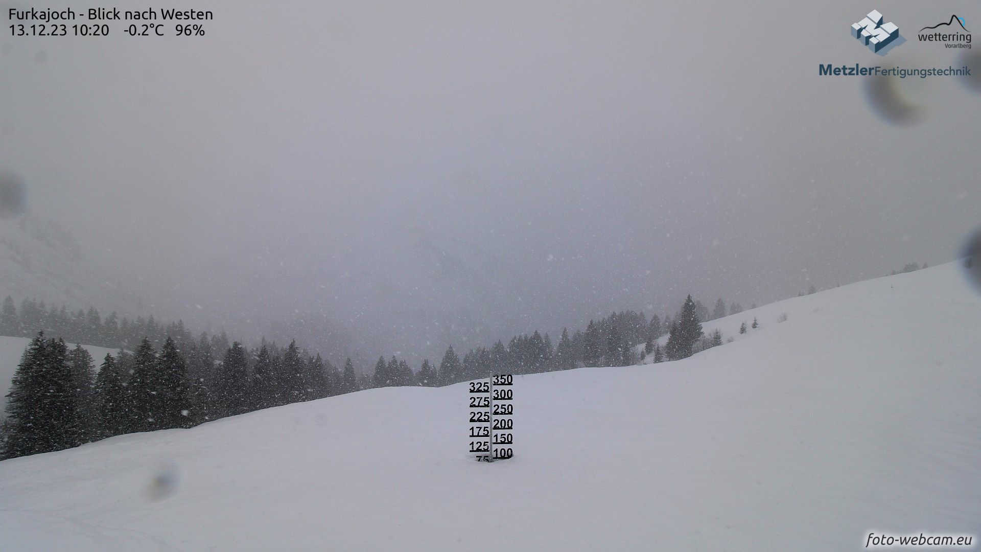
As expected, this region was hit hardest by the rain. The snowline was between 2000 and 2500 metres for a long time. We can see this, for example, in the snow depth at 2250 metres at L’Ecreuleuse near Les Marecottes, which remained more or less the same until yesterday afternoon. Below 2000 metres, however, the snow cover did deteriorate considerably, sometimes losing tens of centimetres. Similarly on the Jaunpass at 1500 metres, where there was 70 centimetres on Saturday, there is now only 20 centimetres left. See the sequence below from a nearby webcam.
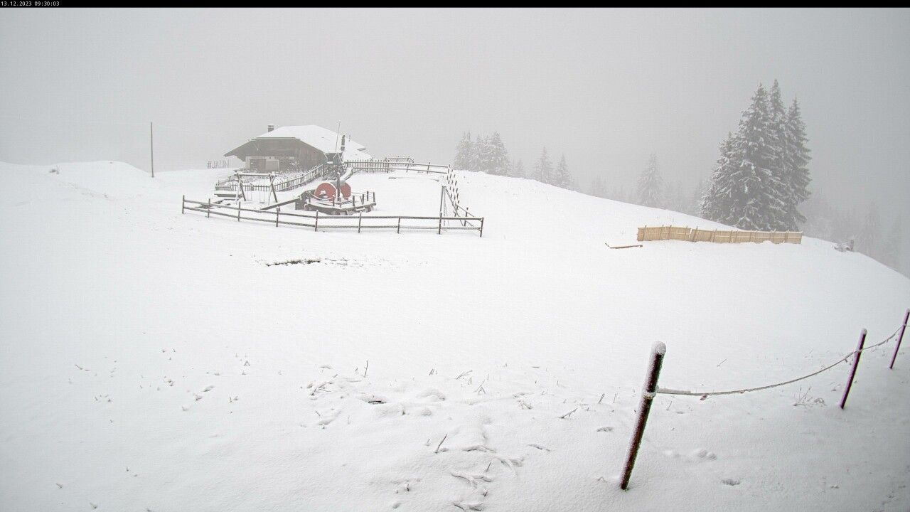
It does show that the snowline already dropped last night and last night. In Jaun, it is snowing at 1,500 metres and also at the L’Ecreuleuse measurement point, we now see a decent snow accumulation of around 30 centimetres already. So the recovery has begun!
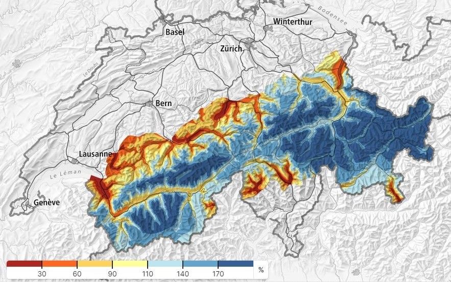
All in all, we should be glad that in many areas the base was already substantial, otherwise it could have had an even bigger impact. Higher up, therefore, the damage remains limited. It is mainly the areas below ~1700 metres that have suffered. You can also see this below in the relative snow depth (source: whiterisk.ch) of Switzerland. Higher up, there is currently loads and loads of snow.
French Southern Alps
Stayed mostly dry, so basically no problems here as expected.
Austria
Generally got through well, although of course it rained here too. On Monday, the snowline here dropped below 2000 metres again in many places, locally around the Arlberg also below 1500 metres. On Tuesday, it did start raining again here too, which continued last night. The higher inner-Alpine areas also picked up snow.
Please note:
For in the coming days: where it has been snowing heavily (northwest Alps >2500m, western Austria >2000m), the wind has also been hitting hard, so the new snow problem & wind slabs are to be taken extremely seriously.
South Alps
Finally, a quick look at the southern Alps. These were on the leeward side, so it remained pretty much dry here until Tuesday, but now the snowfall has also spilled over to this side of the alpine main ridge, so it is now snowing in the Dolomites, Osttirol and the Hohe Tauern, among others. The snowline here is at 1100 to 1500 metres. Some 10 to 30 centimetres will fall here today.

- 1cm
- 5cm
- 10cm
- 15cm
- 20cm
- 30cm
- 40cm
- 50cm
- 75cm
- 100+
- 1mm
- 5mm
- 10mm
- 20mm
- 30mm
- 60mm
- 120+
More snow on the way
So this is the current state, but a lot is going to happen in the coming days. The low pressure area with core over Britain has meanwhile moved eastwards and is now over the Benelux. At altitude, this means it is already about 5 degrees colder (just above zero degrees at 1500 metres), allowing the snowline to drop again during the day. Above you can see the snowfall per 24h for the next few days.
During the night to Thursday, the wind turns to the northwest, allowing it to cool down a few more degrees. The snowline dips even further, with snow below 1,000 metres in many places on the north side. Moist air will be pushed against the northern Alps and with the orographic lift, a nice layer of snow will fall. Tomorrow during the afternoon and evening, the intensity of the snowfall decreases in the French Northern Alps. Friday during the day also in Switzerland. In Austria, it will continue snowing a bit longer.
There is no low-pressure area nearby that swells the Nordstau with additional lift or fronts, so we should not expect bizarre amounts either. However, this does mean that the wind will also play a lesser role during this snowfall. There will also be no stormy winds higher up, although of course it is still important to keep your eyes open for wind slab signals. On Friday, an even slightly colder air mass will reach the Austrian Northern Alps, which is likely to provide Northföhn around the alpine main ridge (Zillertal Alps, Hohe Tauern) and south of it (Dolomites, Osttirol, Carinthia).

- 1cm
- 5cm
- 10cm
- 15cm
- 20cm
- 30cm
- 40cm
- 50cm
- 75cm
- 100+
- 1mm
- 5mm
- 10mm
- 20mm
- 30mm
- 60mm
- 120+
How much will it bring?
The models are struggling with the exact amounts, which still vary a bit in recent model runs.
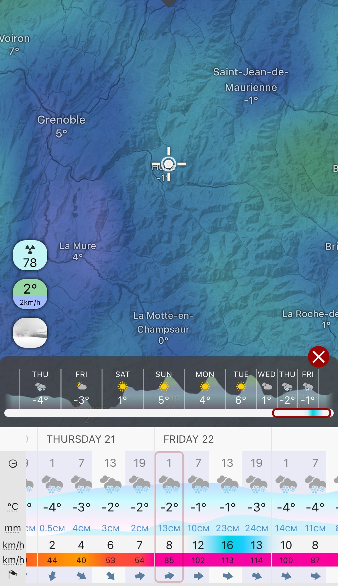
French Northern Alps/West Wallis: This is where the most falls today. I expect 20 to 40 centimetres above 2000 metres. Below that, amounts remain stuck at 10 to 20 centimetres. Some high-res models also calculate up to 50 centimetres in total around Grenoble (e.g. Belledonne).
Switzerland: Here, with the northwesterly flow, the most will fall on Thursday. 20 to 40 centimetres in the nordstau areas until Friday morning, locally also up to half a metre, but this is not yet certain. The snowline will be below 1,000 metres. The snowfall weakens as it moves towards the inner-alpine areas, so significantly less will fall here, e.g. in West-Graubünden. Here it will remain at 10 to 20 centimetres.
Austrian northern side:
After today’s snowfall in the Austrian south side from which the alpine main ridge also benefits, the amounts in the inner-alpine areas likely see less afterwards. Again, this is due to the northerly flow from tomorrow which cannot push the snow showers deep enough into the inneralpine areas. I therefore expect the largest amounts on Thursday and Friday in Vorarlberg, eastern Nordtirol and the Nordstau areas of Salzburgerland up to Hochkar.
Here, around 20 to 40 centimetres of snow (locally half a metre) will fall until Friday with a snowline dropping below 1,000 metres overnight. There is still some uncertainty in the Nordstau situation on Friday. Should it continue with strong showers, an additional 10 to 15 centimetres could possibly fall. At the moment, I am not entirely convinced about this extra snow.
Regional high avalanche danger
I warned already, but I want to reiterate. The wind may not be too bad during the snowfall of the next 72 hours, but this doesn’t mean that nothing is going on. We are currently facing avalanche danger 4 in parts of western Switzerland. It is a complex situation with lots of fresh snow higher up including stormy winds in recent days with rain below. In large parts of Austria, avalanche danger 3 with fresh wind slabs is the main problem. Read the bulletins before heading out.

Sunny weekend, but milder
The weekend will be sunny almost everywhere due to a strong high pressure area right over the Alps. In Austria, there may still be some residual clouds on Saturday morning, especially in the eastern areas, from which there may also be some snow, but in the rest of the Alps it will already be a bright sunny day. On the northern side, this high-pressure setting may allow the low-stratus deck to linger in the Alpine foreland and valleys, which may even be quite persistent at times.
In the Western Alps, it can already warm up considerably during these high-pressure conditions with the descending air movements. In the Eastern Alps, on the other hand, it will remain quite cold throughout the day. The further east, the colder. Sunday will be another bright sunny day, but the warming continues, this time also in the Eastern Alps. It will remain dry for several days after the weekend as well.
Replies
if that will stay it will be very white christmas …
if that will stay it will be very white christmas …Watch3r - 13 Dec 2023 22:14
you never know, its mother nature