
After a long period with mainly westerly winds, the weather picture in the Alps is going to change considerably in the coming days. We will face three days of snowfall, with a different focus each day.

Friday snowfall from the southwest
First snowfall in the French southern Alps approaches from the southwest during Friday. The snow quickly spreads across the rest of the western Alps, including the Italian side. The snowline starts at around 1,500 metres, but drops several hundred metres during the day.
On the northern side, it is still a bit milder at first and with more wind due to the southföhn, but it certainly won’t get warm. In the afternoon, the first snow will also start to fall in Switzerland. Further east in Austria, it will remain dry into the evening, but the first snow will eventually follow from the west. The snowline soon drops to just below 1,000 metres in many places in the Northern Alps.

Saturday Eastern Alps
On Saturday, the first cold air masses follow from the north-west for an increasing pressure gradient between the western north side and south side. This means that the snowline on the north side will drop further (to values between 400 and 900 metres), but it will be increasingly windy in the western southern Alps (French Southern Alps, Piedmont, Ticino and parts of Lombardy) due to the northern föhn. Here it will stop snowing during the night from Friday to Saturday.
In the south-eastern Alps, the intensity actually increases during Friday night and Saturday morning due to the strong southern flow. From the north, increasingly colder air will flow in at the same time, causing a kind of Gegenstromlage, where it will snow on the south side as well as on the north side at the same time.

Sunday remnants in the northern Alps
Sunday, much colder air pours in from the north, with temperatures at 1500 metres in the evening that could drop below -10 degrees. This ensures that the southern Alps, now including the eastern side, can expect Nordföhn on Sunday with thus also quite a bit of snow drift possible. For now, there still seems little room for sunshine.
The north side will get even more snow with a snowline down into the valleys. The biggest amounts then seem to fall on the alpine northern edge.

- 1cm
- 5cm
- 10cm
- 15cm
- 20cm
- 30cm
- 40cm
- 50cm
- 75cm
- 100+
- 1mm
- 5mm
- 10mm
- 20mm
- 30mm
- 60mm
- 120+
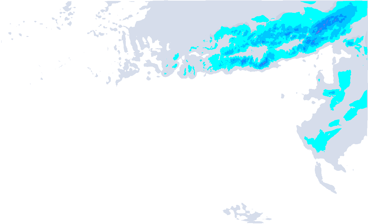
Expected snow amounts (model output from Thursday 4-Jan)
What does it deliver?
It is the question I have been wondering for several days. The models are struggling with it because where the hotspots are is far from clear in this situation. So nowcasting is necessary with this setting. My estimates for now, which don’t quite match our model’s Thursday output above:
First of all, the French southern Alps, here the snow only falls on Friday. It will remain at 10 to 20 centimetres, locally in the Alpes-Maritimes possibly a bit more. In the western Italian Alps (Piedmont) and the southern border area in Valais, the amounts will remain a bit behind. With the south-westerly flow, these areas are largely in the lee and the depression then moves too quickly further east, so I do not expect more than 5 to 15 centimetres in most places.
In most areas in the French Northern Alps around 10 to 20 centimetres, with up to 30 centimetres from the Mont Blanc massif to Grenoble (Belledonne/Oisans). Around Grenoble, some models do hint at an extra layer.
The hotspots in Switzerland in particular seem to be the areas on the alpine edge and Graubünden with 20 to 40 centimetres of fresh snow. Some models still hint at locally half a metre, but this is uncertain. The Engadin is also doing well with around 30 to 40 centimetres, possibly even more.
Dolomites eastern southern Alps
Like our weather model, I expect the largest amounts from the Brenta Dolomites to the Julian Alps, with a focus on the southern areas. Here, over half a metre and in the typical Stau areas locally up to a metre of snow could fall, but the snowline will initially be at around 1300-1500 metres, but dropping a bit afterwards. Further north, amounts decrease, to around 20 to 40 centimetres around the alpine main ridge.
Also for the Austrian Northern Alps there is still some uncertainty in the exact amounts and hotspots. So Sunday seems to see the most fall on the alpine northern edge, Saturday just more around the alpine main ridge. All in all, some 20 to 40 centimetres will fall towards the alpine main ridge from Vorarlberg to the Tauern. These amounts may also fall on the alpine edge from Vorarlberg to Tyrol, but further east towards the Salzburgerland, the amounts decrease considerably.

After that?
After that, it remains dry and especially quite cold with a supply of arctic air from the northeast. Wind chill values will definitely be way lower, as these (north)easterly winds will be quite strong. If there is enough moisture, this flow may cause some more persistent (low) clouds on the north side, but otherwise the sun will get more of a chance.
Some snow may follow early next week in Piedmont, where ski resorts like Prali are currently experiencing severe snow shortages. It won’t be a real retour d’Est according to current calculations, but every little helps.
Replies
Thanks Henri! There’s something for everyone there!
 In Val d’isere sinds vanochtend the hele dag sneeuw. Ik schat zo’n 30-40cm hogerop. West-Alpen hogerop zijn nu echt fantastisch.