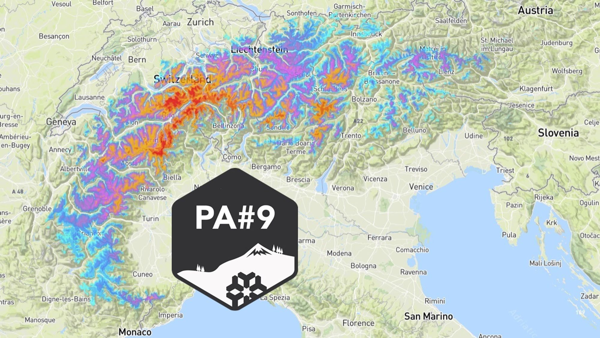
The ski touring and freeride season is still in full swing, but due to the lack of precipitation and high temperatures, the possibilities are becoming increasingly limited. However, from 2000-2500 meters, there is a significant improvement in store for the Southern Alps. Up to Friday, we expect about a meter of snow, especially in Switzerland and parts of Italy and France. After that, more precipitation may follow over the weekend. In this Powder Alert:
- When will the precipitation fall?
- What will the snow line do?
- What type of avalanches can we expect?
- Where to go?
Action from Tuesday to Friday
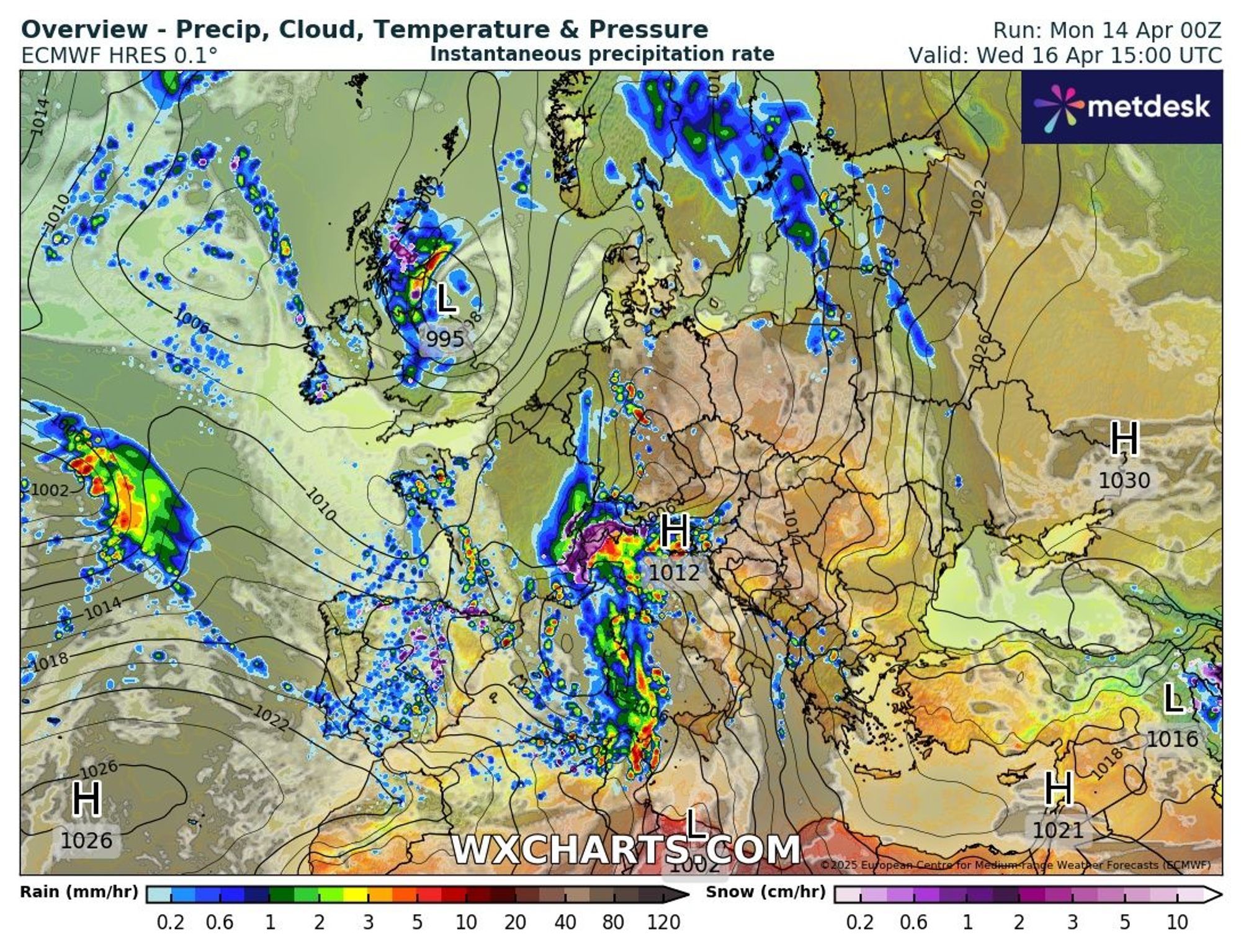
A steering depression will move from Iceland to England in the coming days, while a high-pressure area lies above the Atlantic. This development will cause a northwesterly upper flow in which peripheral disturbances move over Spain and France to Italy. These disturbances will regularly cause precipitation, especially in the Western and Southern Alps. It becomes particularly interesting around the middle of the week when one of these disturbances stagnates near Genoa at the boundary between mild and polar air.
Increasing showers with high snow line on Monday and Tuesday
On Monday afternoon and evening, a few showers will already fall in the French and Italian Alps. The flow is southerly and mild, so it only snows above approximately 2200 meters (a little). On Tuesday, there will be more showers, and they will quickly turn into persistent precipitation, especially in Piemonte, Aosta, Wallis, and Tessin. In these areas and the French Alps, 20 to 40 mm of rain can fall on Tuesday, with snow only above 2200-2600 meters, already a decent amount. Another hotspot can be found in the Julian Alps, the north of Friuli-Venezia Giulia, and the south of Carinthia, with possibly 80 mm of rain until Tuesday evening. Snow will also fall there only (well) above 2200 meters, so only the highest peaks will get some.
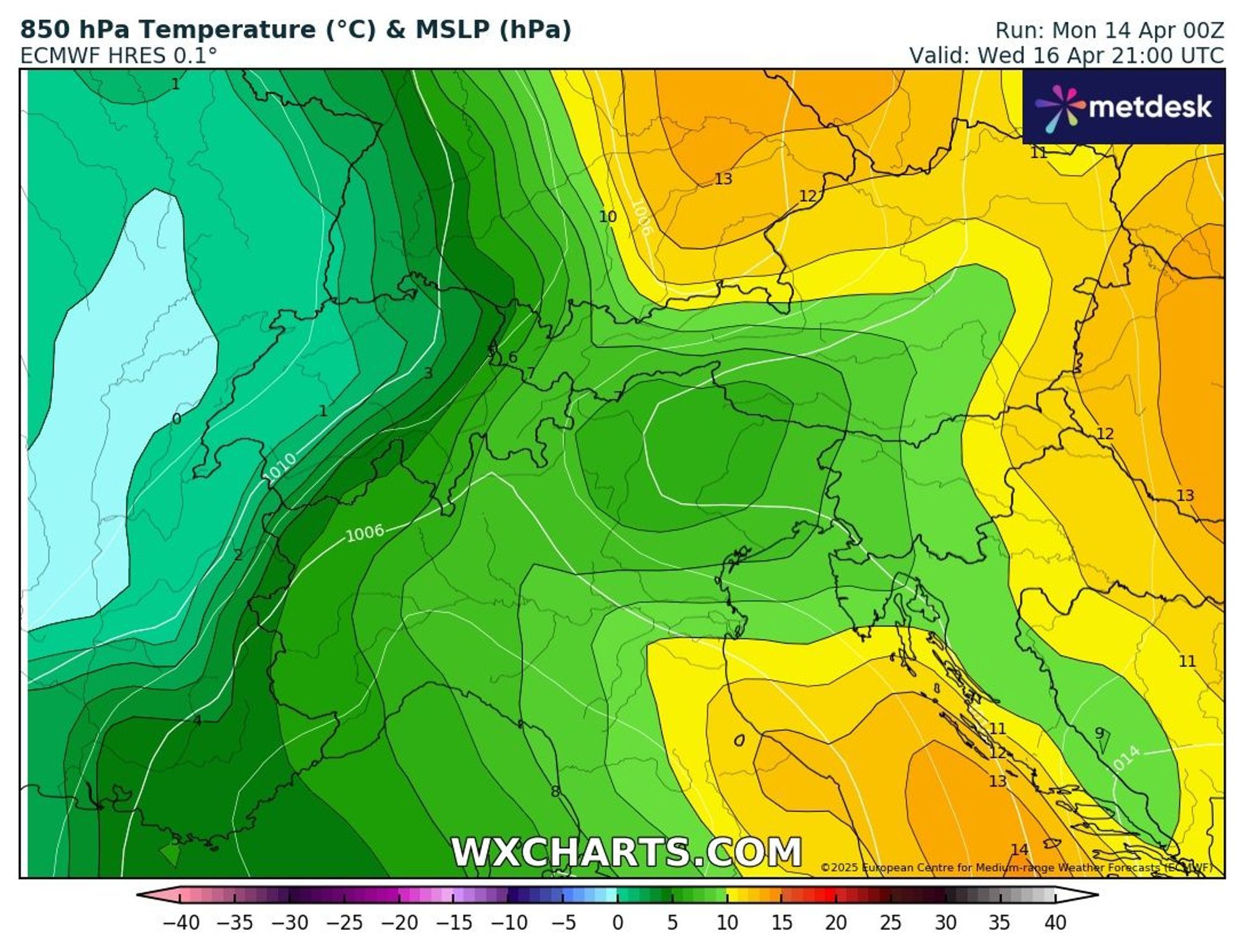
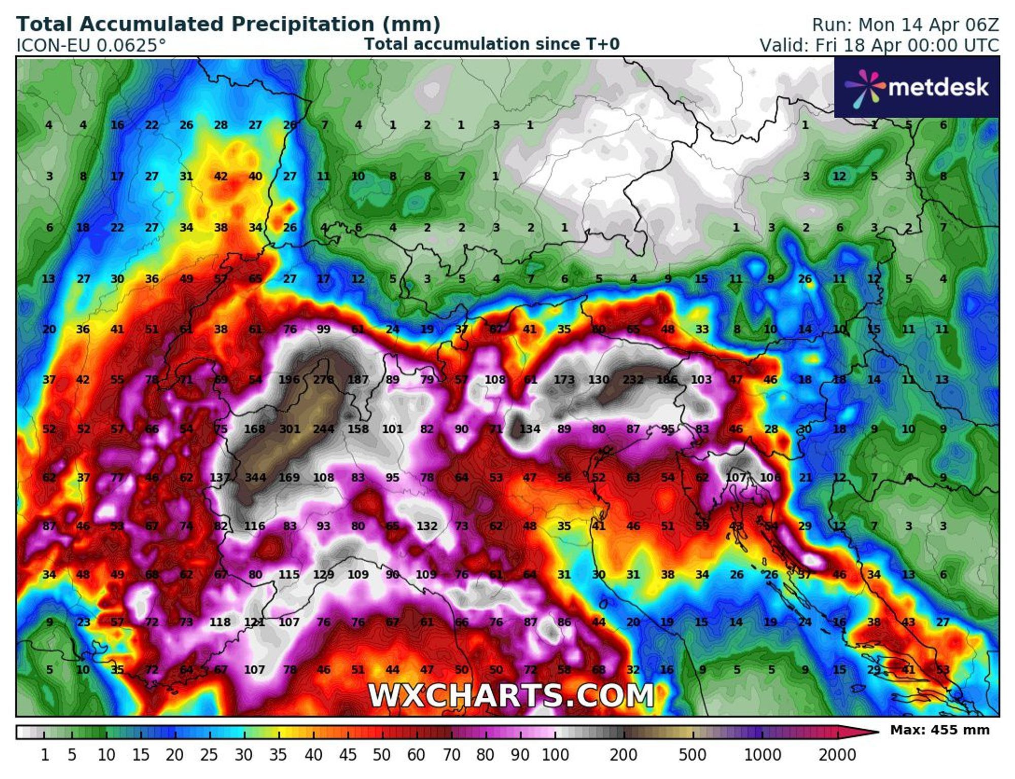
Precipitation bomb and falling snow line on Wednesday and Thursday
The mentioned stagnating disturbance will likely cause a tense situation in Northern Italy and Southern Switzerland. The weather models expect no less than 200 to 300 mm of rain in the southern Alpine valleys and parts of the Po Valley between now and Friday. As a result, streams below 2000 meters can overflow, and spontaneous mud and debris flows can occur. Therefore, it seems wise to avoid the affected areas on Wednesday and Thursday. It mainly concerns the same areas that will already receive a first portion on Tuesday: Aosta, the north of Piemonte and Lombardy, and large parts of Wallis and Tessin. More than 200mm could also fall in the Julian Alps, Karawanken, and a large part of the province of Friuli-Venezia Giulia. In that corner, the snow line remains very high, but in the Western Alps, it will cool down from Wednesday afternoon. In the evening, this will also be the case on the Italian and Swiss sides. The snow line drops, with still intense precipitation, to 1400 to 2000 meters. What falls on Thursday (probably 10-40 mm/cm) will still fall as snow from that altitude,
Indication fresh snow until Thursday
Due to the initially very high snow line and the erratic course of the precipitation, we expect the mentioned meter of fresh snow only above 2300 meters. However, regionally, half a meter can also fall at 2000 meters. An indication per country:
- France: 30-70 cm at 2500 meters, 20-40 cm at 2000 meters (especially around the main ridge and in the French Northern Alps)
- Switzerland: 40-110 cm at 2500 meters, 30-60 cm at 2000 meters (mainly in the above-mentioned cantons)
- Italy: 30-110 cm at 2500 meters, 20-50 cm at 2000 meters (mostly in a strip from Aosta to the Brenta Dolomites)
Avalanche danger already rising, strong increase at altitude from Wednesday
Due to the mild weather, several wet- and glide snow avalanches have already come down in recent days, and the rain will only increase this danger below 2500 meters. On Wednesday, the chance of avalanches due to fresh snow from around 2000 meters will also rise sharply. Some relief is expected only at the end of the week. Always consult the current warnings before you go out.
Where to go? High and West!
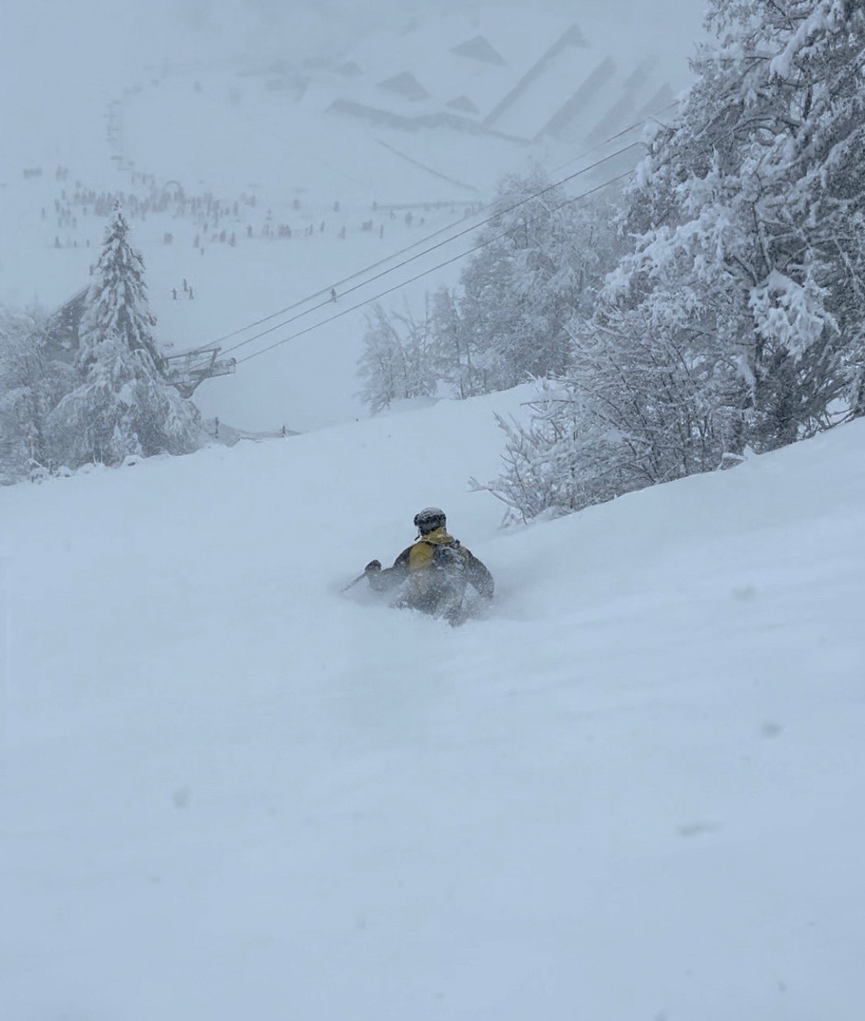
As mentioned, both the extreme weather situation and the rising avalanche danger can cause problems in the Southern Alps. It is advisable to keep a close eye on the media and weather reports in the coming days if you plan to go there. Precipitation decreases on Thursday, and Friday would be the first opportunity to enjoy the fresh powder if the situation allows. This is mainly found above 2000-2500 meters. At that altitude, it remains around freezing on Friday and Saturday, so the snow will be preserved. In the eastern half of the Alps, it remains much milder both during and after the precipitation. The interesting destinations after the precipitation are therefore mainly found towards the west:
- France: Chamonix, Tignes-Val D’isere, 3 Vallees, Paradiski, Bonneval sur Arc
- Switzerland: Andermatt, Engelberg, Zermatt, Saas-Fee, St. Moritz, Mürren, Arosa
- Italy: Courmayeur (the lifts are already closed here), Breuil-Cervinia, Sulden, Monterosa, Livigno, Passo Tonale
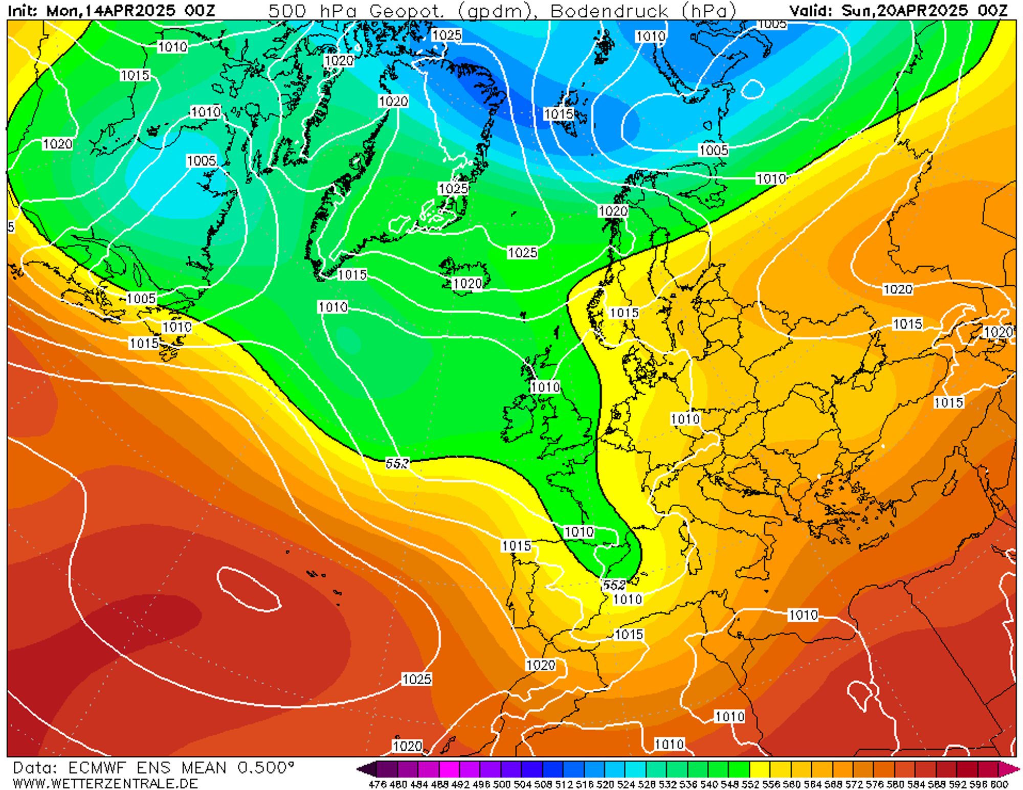
Persistently changeable
The precipitation bomb is over on Friday, but it won’t stay entirely dry for even a day. Later on Saturday, showers will come in from the southwest, and on Sunday, significant amounts may fall again. The snow line will likely be high then too. More details in the upcoming updates!
Replies
Hi Chris, I like your work and the page; although you have been notoriously optimistic about snow amounts this winter, that hardly ever happened. Anyhow, Arosa is my home resort and I am not sure why you put it on the list above. It is very east and the forecast predicts hardly any snow.
Hi Chris, I like your work and the page; although you have been notoriously optimistic about snow amounts this winter, that hardly ever happened. Anyhow, Arosa is my home resort and I am not sure why you put it on the list above. It is very east and the forecast predicts hardly any snow.
[email protected] - 15 Apr 2025 10:00
Hi Michiel,
Thank you for your feedback. I think this season let us all down with disappointing outcomes for several promising events. The predicted amount for Arosa has declined a bit but 20+ cm is still likely at altitude. Because the weather can cause dangers in the most heavily affected areas, resorts like Arosa may be suitable spots in the short term.
Short update today:
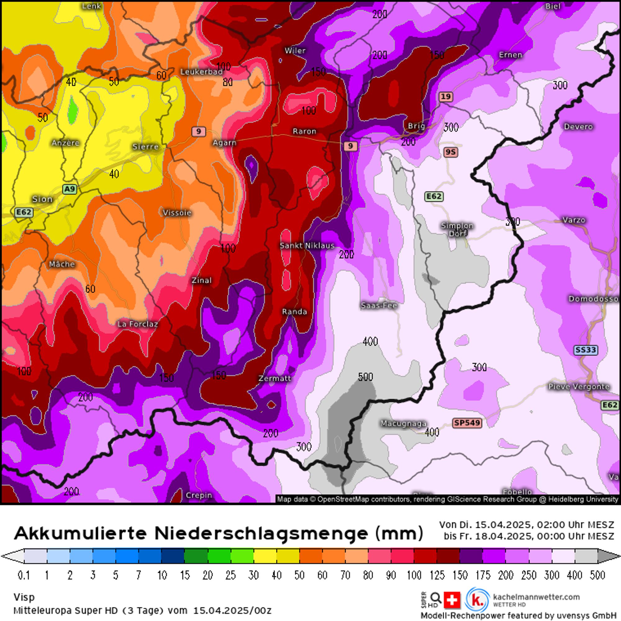
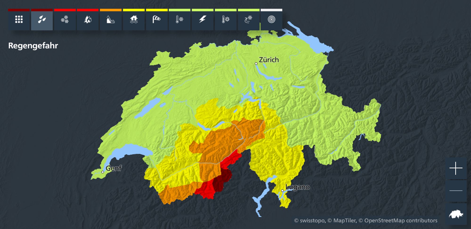
The main thing now is to wait and especially not travel to the hotspot areas before Friday. Until Thursday, there are some absolute no-go areas. Not only in terms of avalanche danger, but also flash floods, landslides, etc, which can be very dangerous in these narrow, steep valleys. Many lifts will also remain closed in the core precipitation area and it remains to be seen if and what will/can open on Friday. Expected amounts are worryingly high according to several models. For Switzerland, this translates into a rain warning Stufe 4 for rain in Oberes Mattertal (Zermatt) and Binntal and even Stufe 5 in Oberes Saastal (Saas-Fee) and Simplon. On a large scale 100-250mm is possible. Higher up even more. More info on all warnings: https://www.meteoswiss.admin.ch/services-and-publications/applications/hazards.html#tab=severe-weather-map&weather-tab=all
On the Italian side, of course, the same problem with very large rain amounts in Piedmont and Aosta.
Thank you for this update Henri. We were considering to leave on Thursday, to Saas-Fee or Zermatt, but you are right. It might not be the best idea. We will wait and see how it develops. Might not be worth the high risk.
Currently in Alpe d’Huez and it started snowing lightly during the morning hours. Right now about 15 cm fresh at 3000 meters.
Poor visibility though and rain below 2000 meters.

Cervinia closed tomorrow.
Monte Rosa also
Now in Meribel. Heavy snowfall all night and 50 cm fresh at 1600 this morning.
Still heavy snow, avy level 5 and all lifts closed.
This is from our hotel Down to centre.