On Saturday, Innsbruck recorded a remarkable 32.4°C — never before has it been this warm so late in the year. The culprit was a strong southwesterly flow, sending warm air across the Alps. As a result, conditions were not only exceptionally mild at the surface but also aloft, with the freezing level climbing to mid-summer values of 4000–4400 meters. But the summerlike warmth is coming to an end. From today, the pattern shifts towards more unsettled and cooler autumn weather. For the high mountains, that even means the first fresh snow is on the way. In other words: welcome to the opening forecast of the 2025–2026 winter season!
Cold front ends the late-summer weather
A low-pressure system with an associated cold front is set to put an end to the summerlike conditions this evening. While the depression isn’t very pronounced on surface charts, it shows up clearly at weather maps higher up (around 5500 meters altitude). Moist air is being transported from the southwest, while cooler air from the northwest tries to push into the Alps. This intrusion only partly succeeds: the south and east remain relatively mild under the influence of the southwest flow, while the west and northwest Alps are more exposed to the cooler air.
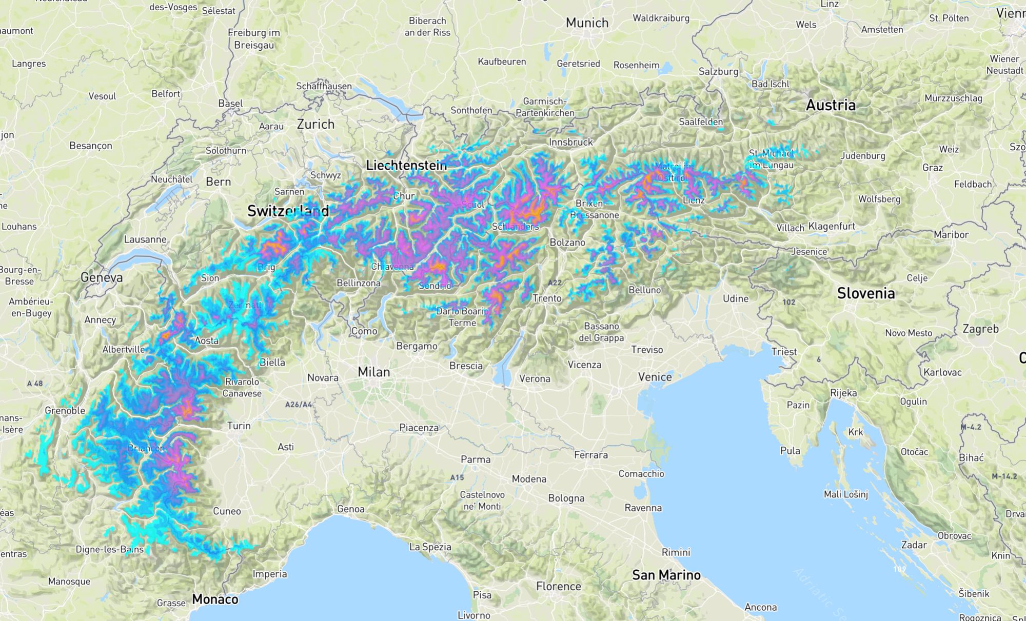
The persistent warm upper-level flow keeps the snow line high at first. Early snowfall will therefore be limited to the high alpine (>2800–3000m), dropping a few hundred meters lower only towards the end of the event. Our forecast highlights the Mont Blanc massif, Monte Rosa region, and further north into the Jungfrau area as the main zones likely to see fresh snow at higher elevations.
Spinning cut-off low
We’re dealing with what’s known as a cut-off low. These systems are notoriously unpredictable: both their track and snowfall distribution are difficult to pin down. Current model runs, however, suggest that this spinning low will linger over the Alps until the end of the week. Since it’s packed with cold air, it will keep conditions unsettled and allow the snow line to gradually sink — potentially down to around 2000 meters.
Temperatures are expected to dip slightly below seasonal averages. Don’t expect an early, major winter outbreak into the valleys like we saw in mid-September last year. Instead, this is more of a typical autumn teaser — the first wintry touch for the high alpine terrain. For Austria, impacts may be more limited: the system probably won’t shift far enough east to deliver widespread snowfall there. Western areas, however, are better positioned.
Which resorts are already open in autumn?
Finally, here’s a quick overview of ski areas across the Alps that are either already open or set to open during September and October.
Austria:
- Hintertuxer Gletscher: 27 September
- Pitztaler Gletscher: 27 September
- Sölden: End September/beginning of October
- Kaunertaler Gletscher: 3 October
- Mölltaler Gletscher: 10 October
- Stubaier Gletscher: 10 October
- Kitzsteinhorn Kaprun: 11 October
Italy:
- Stelvio: Open till November 2nd (might close earlier due to heavy snowfall)
- Schnalstaler Gletscher: already open
- Sulden am Ortler: 25 October
- Breuil-Cervinia: 25 October
Switzerland:
- Zermatt: already open
- Saas-Fee: already open
- Engelberg: 4 October
- Sankt Moritz - Diavolezza: 18 October til 16 November (we, sa, su)
Replies
w0000000000000000000000000000000000ttttt!!!