In today’s weather forecast we focus on PowderAlert #2. Expected snowfall totals have certainly not gone down! This is my first contribution to this platform (more on that later), and I’m landing straight in the good stuff - a PowderAlert!
In this weather update we’ll cover:
- The initial situation yesterday and today
- Day-by-day snowfall in the Southwestern Alps
- Where to go? Base depth and avalanche risk
- Outlook toward the end of the week
Mild with Kaiserwetter and some rain on Friday
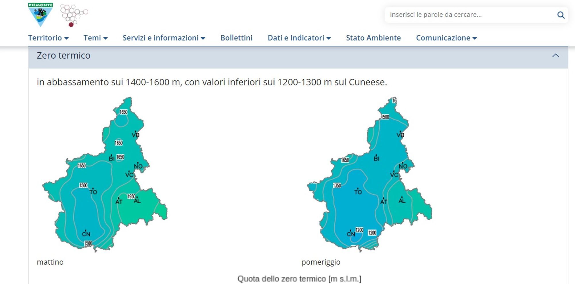
Friday showed strong contrasts across the Alps. Temperatures were mild everywhere, but while Austria enjoyed classic Kaiserwetter, the Southwestern Alps were cloudy. Especially in the Alpes Maritimes, rain fell, with snow only at higher elevations (above roughly 2,000 m). Station measurements show 5-10 cm of fresh snow, but at 2,200-2,500 m the base is still thin, only 20-40 cm. In Piedmont it remained cloudy and mild, and even this morning little has changed. The regions which got a decent amount of snow earlier this week, melting and compaction have already reduced snow depth by 10-20 cm. But that’s about to change!
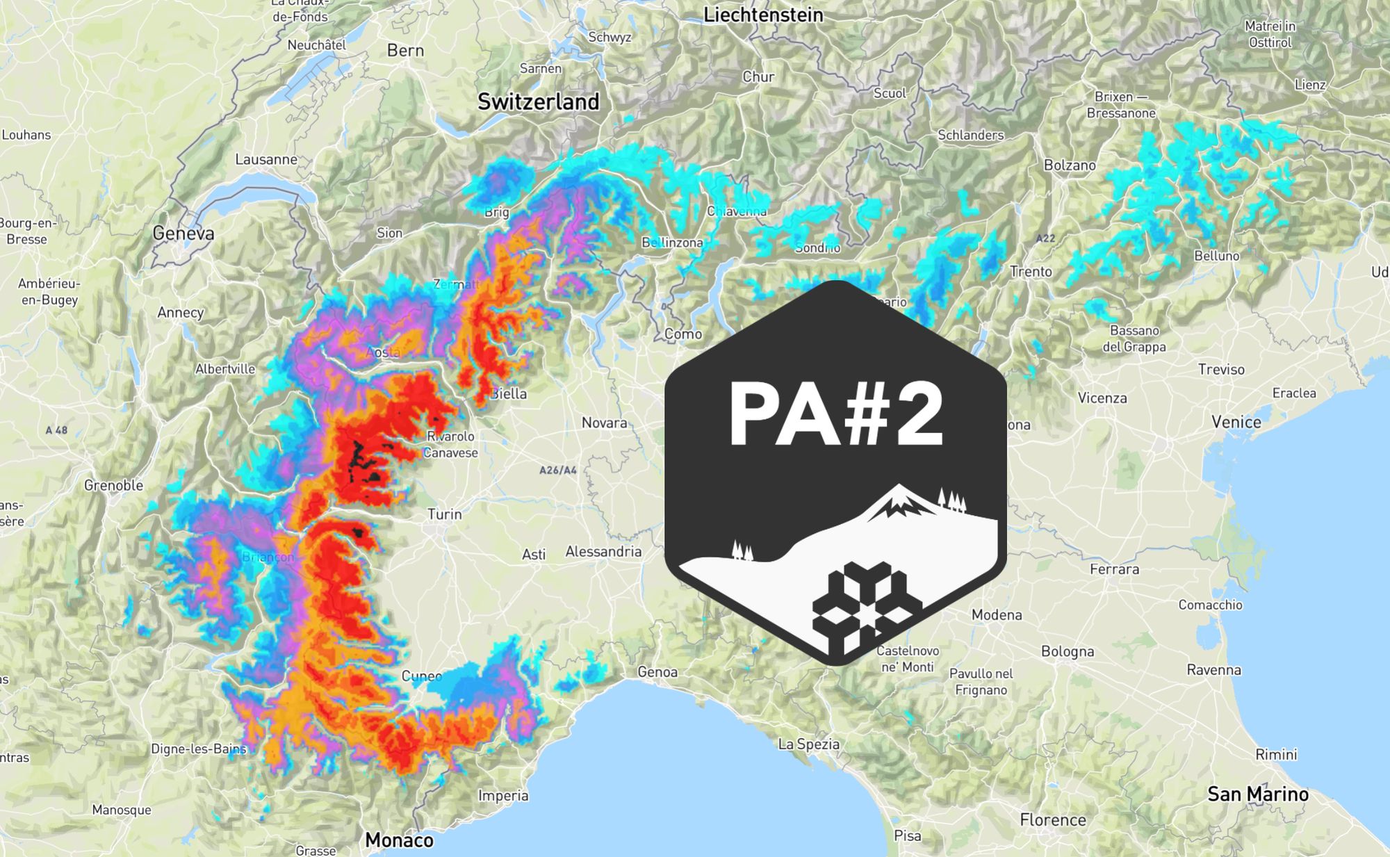
Snow situation in the Southwestern Alps - day by day
A low-pressure system west of Europe will drop south toward the Mediterranean over the coming days. Today, the Alps are still strongly influenced by mild air being transported northward ahead of this system. As the low shifts southeast, a high-pressure system builds over Scandinavia. On its eastern flank, a cold northerly flow develops, which will gradually reach the Alps later this week in a moderated form.
Today and tomorrow - Southwestern Alps
Today remains mild everywhere, with the freezing level often at or above 2,000 m. In the Cuneo region of Piedmont, intermittent rain is falling, with snow only above 1,600-1,800 m. On Sunday, little changes at first. During the afternoon and evening, precipitation intensifies and the snow line gradually drops to around 1,400 m, locally down to about 1,000 m in strong orographic precipitation zones such as Limone.
Monday: full-on snowfall
Sunday night into Monday, and throughout Monday, it’s full send in the Southwestern Alps as the retour d’est fully kicks in. Snowfall won’t be limited to southern Piedmont; it extends much farther north, reaching areas such as Via Lattea and Monte Rosa (Alagna). Above 1,400-1,600 m, widespread snowfall of 50+ cm is expected, with local totals exceeding 1 meter. In the most intense snowfall zones, the snow line may drop to around or even below 1,000 m. Due to strong upper-level winds, areas along the Swiss main Alpine ridge (such as Saas-Fee) and the French main ridge (Val d’Isère) will also likely pick up 20-40 cm. The same applies to smaller French resorts along the ridge in the Queyras, such as Abries and Saint-Véran. Wind will be a significant factor, especially in high-alpine resorts. Snow may also reach the Écrins Massif and the true Alpes Maritimes on Monday.
Check here the expected 24h-snowfall according to our forecast. Use the slider:


- 1cm
- 5cm
- 10cm
- 15cm
- 20cm
- 30cm
- 40cm
- 50cm
- 75cm
- 100+
- 1mm
- 5mm
- 10mm
- 20mm
- 30mm
- 60mm
- 120+
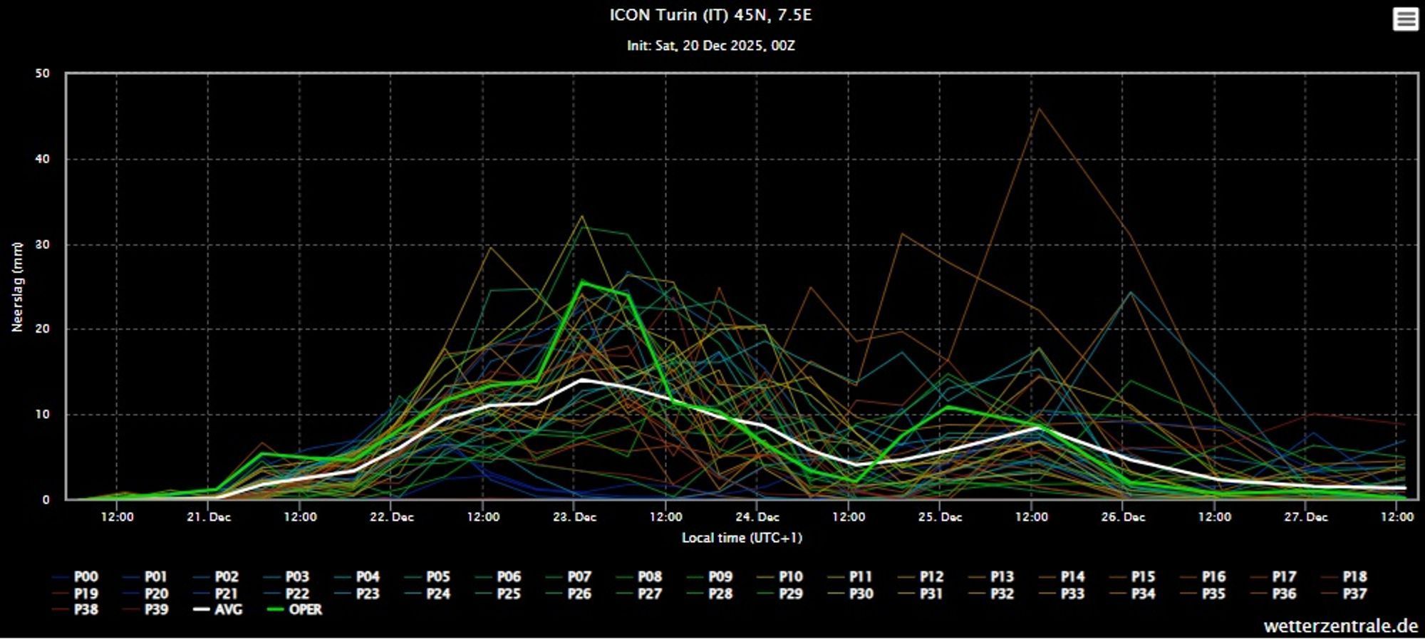
Tuesday and Wednesday
The outlook for Tuesday and Wednesday is still quite uncertain. An easterly flow persists over the PowderAlert #2 region and temperatures drop further. Snowfall intensity decreases, but there are signals for an additional push of snow. If that happens, the snow line would drop clearly below 1,000 m. We’ll monitor this closely over the coming days. Cloud cover is likely to persist regardless.
Where-to-go? Base depth and avalanche risk
The most recent snowfall earlier this week was mainly limited to southern Piedmont. There, the base is solid, despite some melting up to today. From Monday onward, the combination of fresh snow on an existing base makes this region the best option. That said, it remains to be seen how intense the snowfall becomes and what impact it will have on lift operations. Farther north and along the main Alpine ridge (Via Lattea, Val d’Isère, Alagna, Saas-Fee), conditions could also become interesting. However, the base there is significantly weaker, with even well above 2,000 m often old and icy snow. This is not an ideal base from an avalanche perspective, so don’t forget: always check local avalanche bulletins before you head out!
Wind will also play a bigger role in these areas. Finally, smaller French resorts in the Queyras could be an option, but snowfall amounts there are still uncertain. Expect widespread cloud cover and poor visibility through at least Wednesday. Clearings should follow quickly after that.
The Alps from wednesday onward
From Wednesday, colder air from the northeast starts gaining ground across the Alps. While Austria may still see some sunshine and mild conditions early in the week, Wednesday and Thursday bring a shift: colder temperatures and mostly cloudy skies. Some light snowfall is possible, but amounts will generally stay limited to a few centimeters, with inner-alpine regions likely remaining mostly dry. In the Southwestern Alps, there is still a chance of easterly snowfall through Thursday, depending on the strength and position of the low-pressure system lingering near Sardinia. From December 26th, clearing skies look likely everywhere, along with truly wintry temperatures and several dry days.
Personal Introduction
As mentioned in the intro, this is my first contribution here. I’ll be supporting Henri and Chris in the team to keep you updated through this platform and I’m stoked to do so, as it lets me combine my passion for the mountains and skiing with my passion for weather. I learned to ski early in Elbigenalp (Tyrol). After plenty of time on groomers, I moved into off-piste terrain. I’ve spent many days touring with guides, a highlight being a three-day tour through the Écrins starting from La Grave. Through courses and hands-on experience, I’ve built solid knowledge of avalanche science and route selection. Meteorology became my profession, and I worked for many years as a meteorologist. These days I’m involved in the energy transition, but this platform lets me keep applying my weather passion in practice.