
- 1cm
- 5cm
- 10cm
- 15cm
- 20cm
- 30cm
- 40cm
- 50cm
- 75cm
- 100+
- 1mm
- 5mm
- 10mm
- 20mm
- 30mm
- 60mm
- 120+
Why we shouldn’t take this snow map too literally is explained in this weather report
Chris already gave a clear picture of the outlook for the Alps yesterday, so after a brief update on that, today I’ll also focus on the weather in Scandinavia, because a lot of interesting things are happening there right now. A summary of what I’ll cover in this report:
- Two small snow moments in the eastern Northern Alps
- Air mass boundary this weekend?
- Scandinavia update

Two snow moments in the eastern Northern Alps
Tomorrow some snow will fall in the eastern Northern Alps, especially in areas east of Innsbruck. It certainly won’t be much: I expect 1 to 5 centimeters in most areas, with a maximum of around 10 cm near the Dachstein massif. Still, in the Northern Alps every bit of snowfall is welcome at the moment. New Year’s Eve will also bring light snowfall to this corner of the Alps, again around 1 to 5 centimeters. Nothing spectacular, but thanks to the inflow of cold air the snow line during these snow moments will drop all the way down into the valleys.
Cold air is also being advected at higher elevations, temporarily resulting in temperatures of -15 to as low as -20 degrees Celsius at 3000 meters in Austria. In the Western Alps it remains milder. In the eastern Southern Alps, the Nordföhn will peak on Tuesday due to the influx of cold air from the north.

- -20°
- -15°
- -10°
- -5°
- 0°
- 5°
- 10°
- 15°
- 20°
Air mass boundary this weekend?
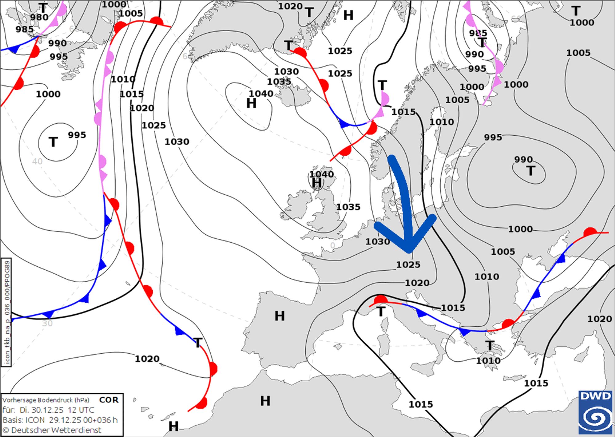
Yesterday Chris already clearly described the developments for the weekend, with two key low pressure systems: one over Scandinavia, filled with cold air that could plunge Europe into winter weather, and a smaller-scale depression near Portugal. The models are currently struggling with what exactly will happen, but it increasingly looks like we’re heading toward an air mass boundary this weekend.
An air mass boundary is the transition zone between two air masses with different properties, such as temperature and humidity. Along such a boundary, intense precipitation often develops. Convergence of different air masses leads to extra lift, which can result in locally heavy precipitation. The caveat is that it often remains unclear for a long time where exactly such an air mass boundary will set up, and it usually only becomes clear within 24 hours of the event itself. A small shift can therefore have a major impact on where snow will fall, which is why we can’t provide those details yet.
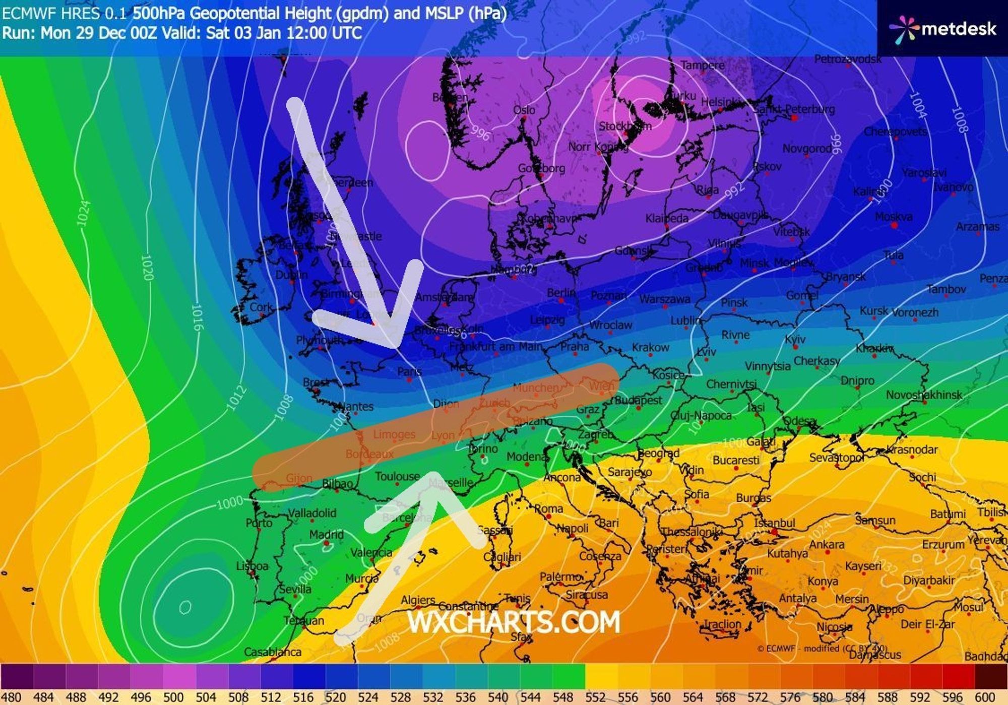
One characteristic of precipitation along such an air mass boundary is that topography plays a smaller role, meaning that large precipitation amounts tend to fall more uniformly over a broader area and are less elevation-dependent, potentially resulting in significant snowfall even in the valleys. The sting in the tail, however, is that you could end up just on the wrong side of the boundary and deal with rain and/or freezing rain instead of snow.
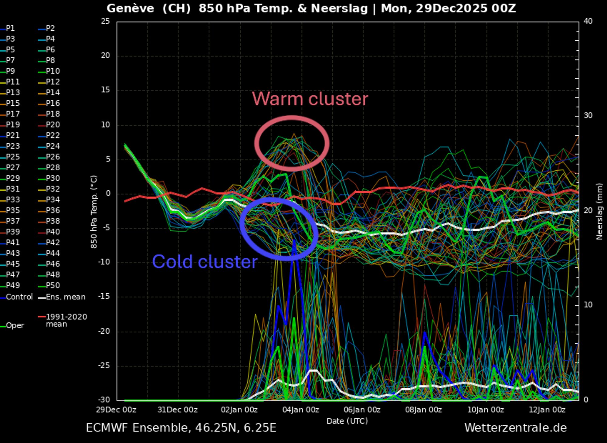
This pitfall is clearly visible in this morning’s EC ensemble, which showed a kind of bifurcation with a warm cluster and a cold cluster (with the main run (green) roughly in between). For comparison, I’ve added the considerably milder GFS ensembles for Geneva from this morning (left) and this evening (right) below. Here too, the spread for this weekend is evident, showing just how large the run-to-run differences are (even the main run alone is a world of difference). Also note how the precipitation peak differs between today’s GFS runs.
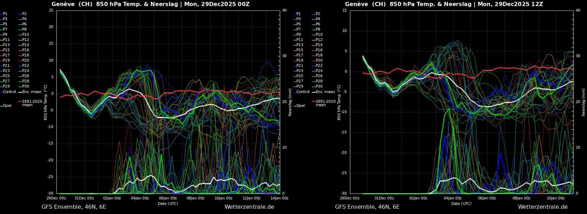
Large differences in today’s GFS ensembles (wetterzentrale.de)
In their main runs, both EC and GFS place the air mass boundary somewhat northwest of the Alps, which would put the Alps on the milder side of the boundary. In that scenario, especially the Western Alps and Southern Alps could still see substantial precipitation, but in the milder air the snow line becomes a key concern. I’ll leave it at that for now, because anything beyond this would be pure speculation.
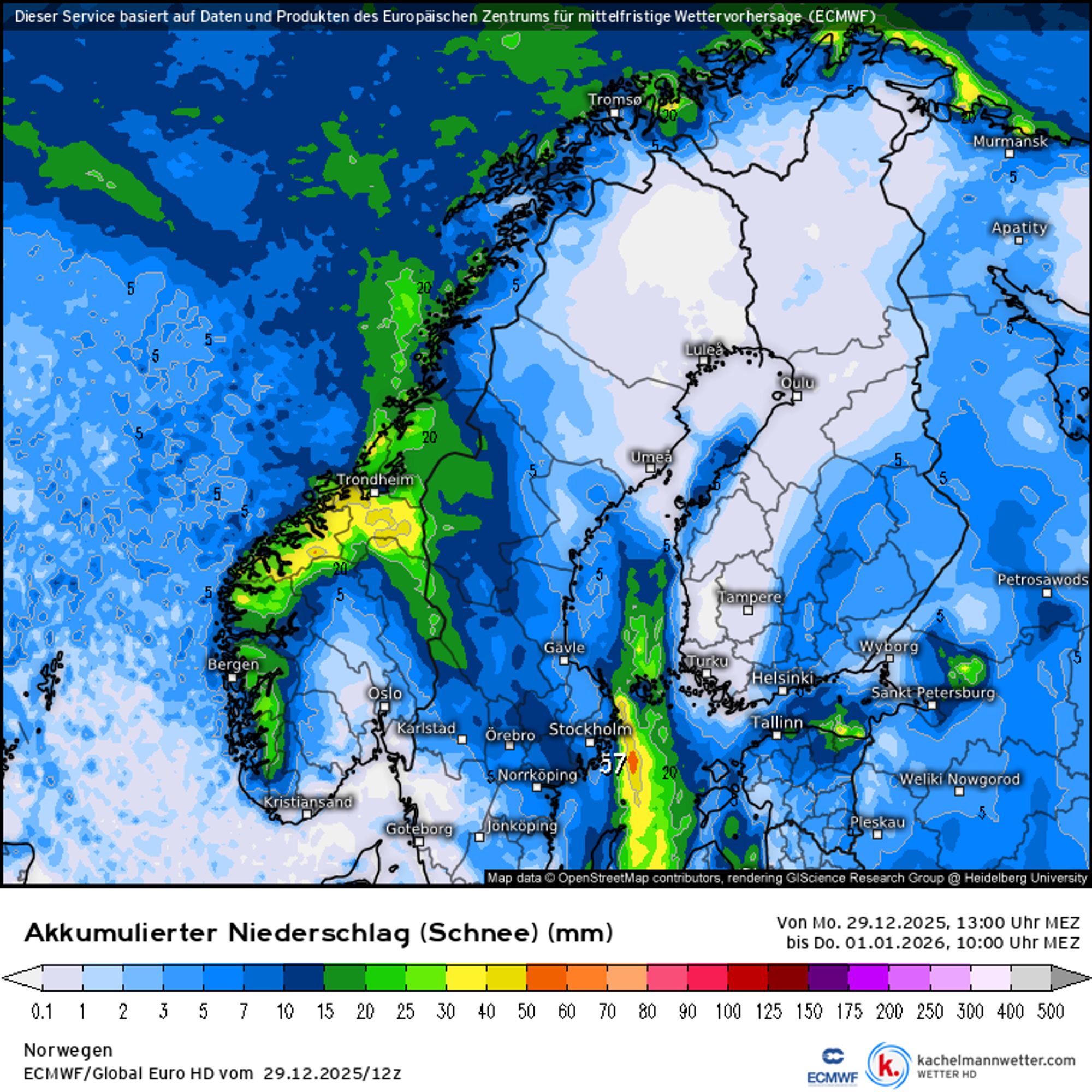
Scandinavia: mild Christmas, stormy sequel, now wintery
Finally, I want to talk a bit about Scandinavia, because regionally there is currently a lot of snowfall. To give a fuller picture, let’s take a few steps back to the Christmas period. At that time, temperatures shot up, with maxima of up to 10 degrees Celsius in central Sweden and parts of Norway, and well above freezing (both day and night) north of the Arctic Circle, partly due to strong föhn winds. Avalanche danger rose rapidly, especially in the northern regions, as the snowpack became wet, with regionally avalanche danger level 4 on Christmas Day.
At the end of Christmas, the weather flipped. Storm Johannes caused widespread disruption. On a large scale, wind gusts of 100 to over 150 km/h were observed, with an extreme gust of 200 km/h measured on Andøya. With these winds, wind-drifted snow naturally became a major issue. Especially at higher elevations, avalanche danger remains high due to fokksnø (wind slabs), and avalanches can be triggered from a great distance.
Cold and moist northerly flow
The storm resulted in a cold and moist northerly flow afterwards. Initially, the snow line was still fairly high, but by Sunday it had already dropped to a few hundred meters in mid-Scandinavia and down to sea level in the north. Even today, snow continues steadily in the Norwegian coastal regions, with a combination of heavy snow and graupel showers and stormy winds.
The coastal regions of Møre og Romsdal, Trøndelag, Nordland and Troms benefit the most from this setup. South of the Jostedalsbreen-Dovrefjell line, areas lie in the lee of this flow, meaning that apart from some light snowfall it remains largely dry there. For the Swedish regions we see: from Åre northwards it snows, and the closer you get to the Norwegian border, the more snow you’ll find - though don’t expect huge amounts. All in all, we’re talking about roughly 10 to 50 centimeters of snow already fallen, with another 10 to 40 centimeters on the way. Naturally, wind and associated snow transport lead to large local differences. Needless to say, the avalanche situation will be tricky due to the wind.
The showery nature of this snowfall also contributes to large local variations. Around New Year’s, a small low-pressure system will move across southern Norway, temporarily bringing snowfall from western Norway to Innlandet and even across into Sweden. After that, Scandinavia dives into the deep freeze and conditions generally become drier. However, small-scale low-pressure systems embedded within the larger low-pressure pattern could still bring some additional snowfall.