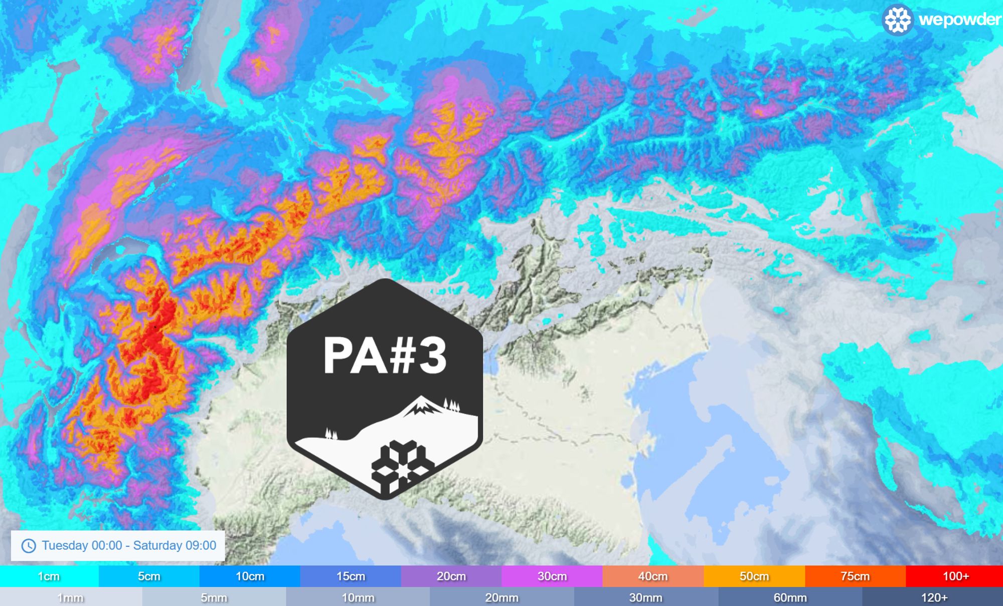
Finally, it’s time for some serious snowfall again and therefore PA#3. Without wanting to spoil the fun, there are five important caveats to take into account, all explained in this forecast. In this Epiphany weather update I’ll take a deeper dive into the three depressions that will affect the Alps.
In this forecast:
- First a weak precipitation front
- Deepening low bringing significant snowfall
- PA during the weekend
- The caveats
- Where to go?
- Third depression on the mid-range outlook
First depression with a weak front
Let’s start by going up high. In the upper troposphere we see a fairly strong but also strongly meandering jet stream over the coming days. On Wednesday the first Atlantic depression approaches. With a northwesterly upper-level flow, this small low is already deepening today and bringing some snow to Scotland. In a very weakened form, this precipitation front reaches the Northwestern Alps on Wednesday evening. More than a dust on crust isn’t in the cards for the French Northern Alps and western Switzerland, but that will change quickly during Thursday.
Deepening low
On Thursday and Friday the jet stream becomes more zonal and aligns directly with the Alps. Under its influence, a rapidly deepening low-pressure system approaches from the west. This low intensifies quickly (with steadily falling core pressure) near the left exit region of the jet streak, the zone of highest wind speeds within the jet stream. Without going too deep into meteorological theory: in this left-exit region, divergence aloft occurs, leading to upward motion and, at the surface, convergence and the formation of a low-pressure system.
Once over the continent, this low more or less stalls during Friday and Saturday, and this is exactly where forecast uncertainty increases. Around the deepening low, a strong wind field develops on Thursday and Friday, mainly affecting the Northwestern Alps. Over recent days, the models have not been fully aligned on this: EC in particular simulated a very strong wind field, while GFS was more moderate. I’ll come back to the wind later on.
Rising snow line
This low-pressure system is the main driver of snowfall in the Northwestern Alps over the coming days. However, on its leading edge it also draws in warmer air: this is caveat number one. On Thursday, precipitation quickly intensifies from the west and initially falls as snow in most areas, but the Western Alps soon enter the warm sector of the low.
Existing cold air pools can keep the snow line low for quite some time, especially in narrow inner-alpine valleys. From the west, however, the snow line will temporarily rise as milder air pushes in and precipitation intensifies. I wouldn’t be surprised to see the snow line lingering around 1000 metres in inner-alpine areas for an extended period, while outer ranges such as the Chablais, Aravis and Chartreuse will likely have to deal with a snow line around 1500 metres, or temporarily just above. Not a disaster, but definitely something to factor in.
PA during the weekend
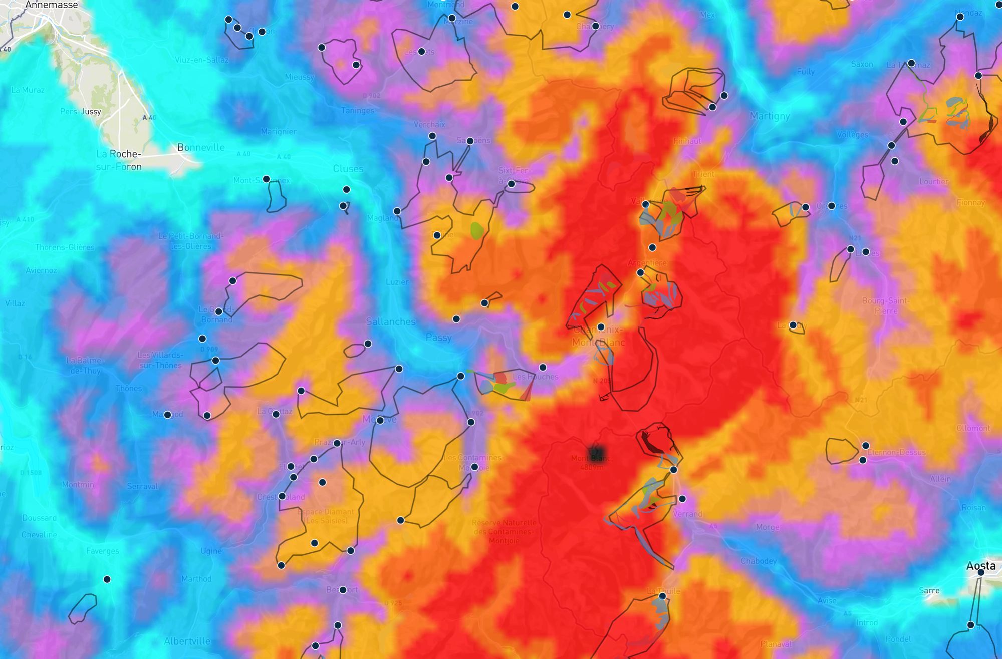
During the night into Friday, the cold front of the system passes through and cooler air flows in. The snow line drops below 1000 metres during the morning and locally even lower. In the French Northern Alps and the western half of Switzerland, snowfall continues through to the night into Saturday, with accumulations really starting to add up. This is the core snowfall zone and the heart of this PowderAlert. On a broad scale, 30 to 70 cm will fall across the French Northern Alps, western Valais and the Bernese Oberland. Further east, amounts (at least until Saturday morning) will be lower. At higher elevations in the hotspots, especially around the Mont Blanc massif, accumulations can reach up to a metre.
The caveats
To summarise, here are the key caveats that come with this PA:
- The warm sector
- Wind
- No guarantee for the Northern Alps
- Moderate to poor base
- Avalanche danger
The warm sector
Thursday through Friday morning. Snowfall, especially in the ranges on the edge of the Alps, will turn to rain, with a temporary snow line around or just above 1500 metres. From Friday afternoon onwards, the snow line is no longer a concern, dropping all the way into the valleys.
Wind
The westerly wind becomes a major factor, especially during the night into Friday and throughout Friday. At higher elevations, storm-force conditions are expected with gusts of 100–150 km/h. Whiteout conditions and lift closures are likely. The northwesterly wind later on Saturday also increases and can still be strong at altitude, but not as extreme as the westerly phase.

- 0-2 bft
- 3-5 bft
- 6 bft
- 7 bft
- 8 bft
- 9 bft
- 10 bft
- 11 bft
- 12 bft
No certainty for Northern Alps snowfall
The focus is clearly on the Northwestern Alps, from the French Northern Alps through Valais and into the Bernese Oberland. From Central Switzerland to the Arlberg, snowfall totals up to Saturday morning lag well behind those in the French Northern Alps and Valais. For areas east of the Arlberg, confidence is currently a bit low; totals there are likely to remain modest through the weekend. Much depends on the exact flow direction once the low stalls over Germany on Saturday. A more northerly flow, bringing snow down to most valleys later on Saturday, is certainly possible, but for now I’ll leave that scenario aside. We’ll give an update on this in the detailed forecasts over the coming days.
Moderate to poor base
Aspect is key in lower-elevation terrain at the moment, as shown by the webcam images from Le Grand Bornand above. West- and north-facing slopes have a thin but workable base down to relatively low elevations, while full south-facing slopes remain exposed up high, a situation that currently applies to many areas in the Northern Alps.
Avalanche danger
Last but not least, and a very important caveat: the avalanche danger. Expect danger level 4 at higher elevations across large parts of the French Northern Alps and western Switzerland on Friday and Saturday. Conditions will be tricky: large snowfall amounts on a base that is mediocre in both quality and quantity, combined with very strong winds, especially on Thursday and Friday. Make sure to follow the avalanche bulletins (link to FR and CH).
Don’t take these risks. The combination of factors makes this, in my view, a PA that you don’t need to chase at all costs. Let this snow fall quietly to finally establish a solid base, and wait for the next snowy phase before going all in. If you’re already nearby, there will of course be some good options, which is why I’ve still decided to issue this PA.
Where to go?
On Friday, snow is still falling across many areas, with particularly heavy snowfall continuing in Haute-Savoie, Savoie, and the western parts of Valais and the Bernese Oberland. In the outer ranges, you may be coming out of a rainy night, but here too the snow line drops and accumulations increase. Low-elevation north- and west-facing slopes with grass underneath or a thin base are easy to find and will ski well from Friday onwards, especially over the weekend. Focus on these areas on Friday and Saturday. Think of places like for example Arêches-Beaufort, Megève and surroundings, Balme-Vallorcine, all the way to Gstaad. It’s just a small selection from the many options listed in the wePowder Guide. You can also check out the forecast, where all ski areas are plotted on the map.
Third depression
On Sunday, some clearings are expected during the day, especially in the French Northern Alps. More information on snowfall beyond that (Saturday/Sunday for the Northern Alps) will follow in updates over the coming days. Still, a brief look further ahead: a third depression initially remains at a distance over the Atlantic. Earlier model runs suggested it could grow into a larger system with increased rain chances for the Western Alps, but recent runs do not support that scenario.
What does seem likely is a temporary warming early next week due to a southwesterly flow ahead of this low, on Monday in the Western Alps and on Tuesday increasingly also in the Northern Alps. Especially at lower elevations, the snowpack will quickly become heavier, meaning you’ll need to head higher up. As always, keep avalanche danger firmly in mind.
Replies
Magic Megève in the Powder Alert when you’re coming in hot. Santa didn’t deliver presents like this 😍