Today we obviously take a closer look at the upcoming PA#3, which Henri already covered extensively yesterday, and zoom in further on several aspects. We’ll also pay attention to the “weak” first front that is already bringing snow further west. Finally, we look toward the Ardennen and Sauerland mountain ranges, where snow is also showing up on the charts. In summary:
- First front mainly brings snow over Western Europe
- PA#3 on track – latest insights
- Warming and precipitation on Monday
- Caution advised
- Preferred regions to go?
- Also more snow Belgium and German regions

First front mainly brings snow over Western Europe
From today onward, disturbances from the west attempt to push into Europe. Initially, this happens somewhat hesitantly — and after a cold spell, mainly as snow. In the Benelux and France, snowfall has caused significant traffic disruption, but of course also plenty of snow fun.
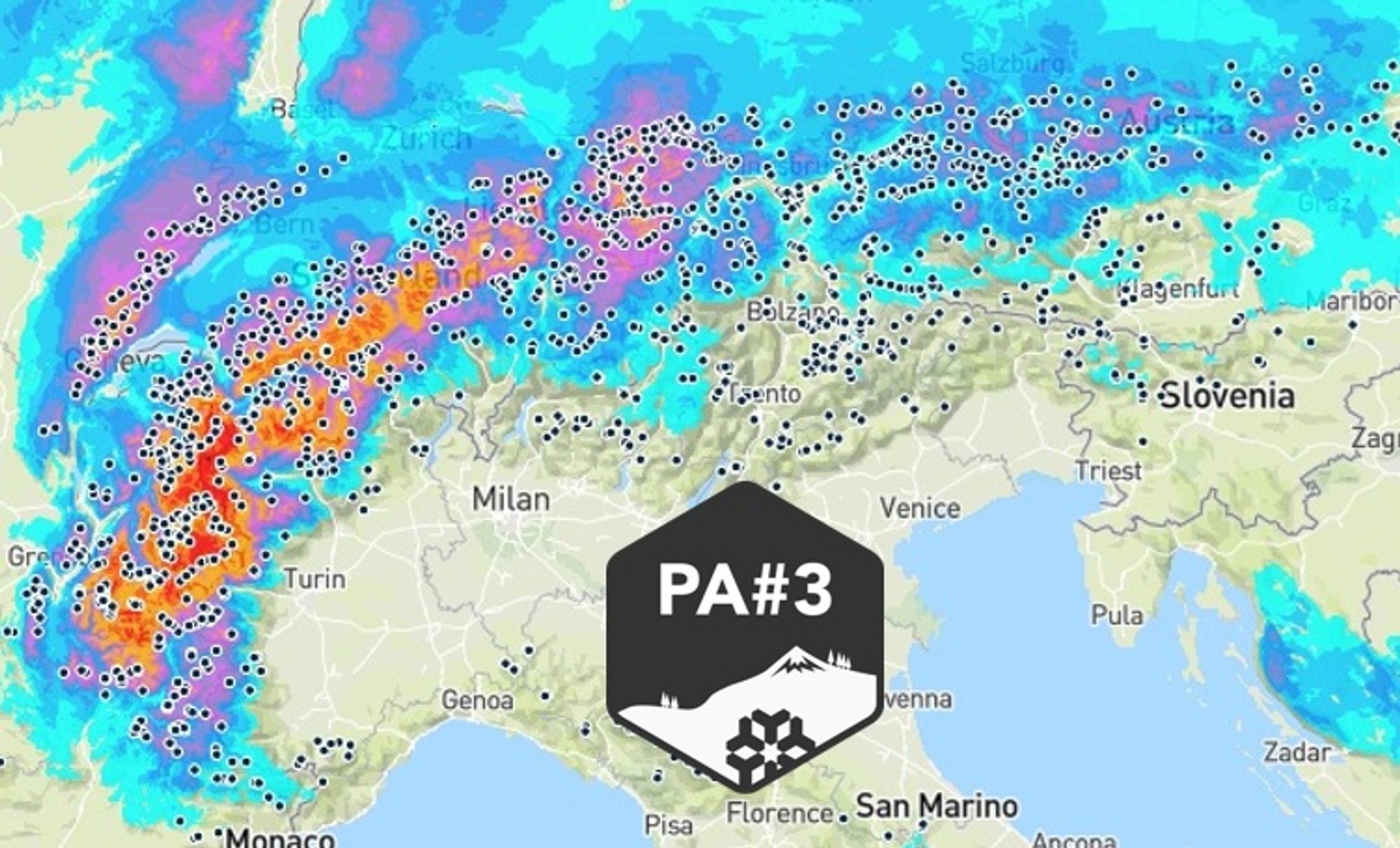
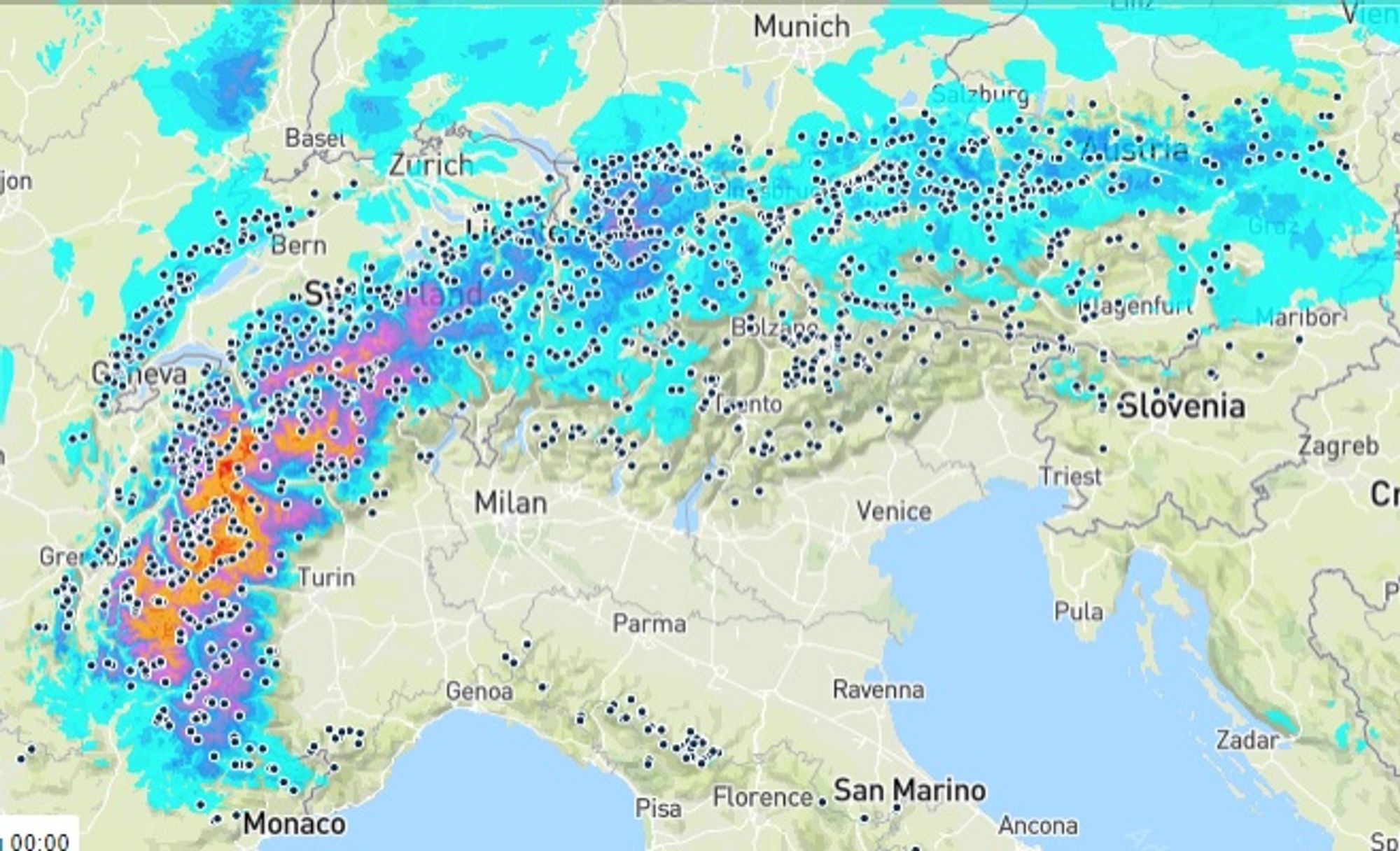
PA#3 on track – the latest insights
A first “thaw” front often dissapates over the European continent — and that’s exactly what’s happening this time. This evening, the precipitation zone reaches the Western Alps in a weakening state, producing at most a few centimeters of snow.
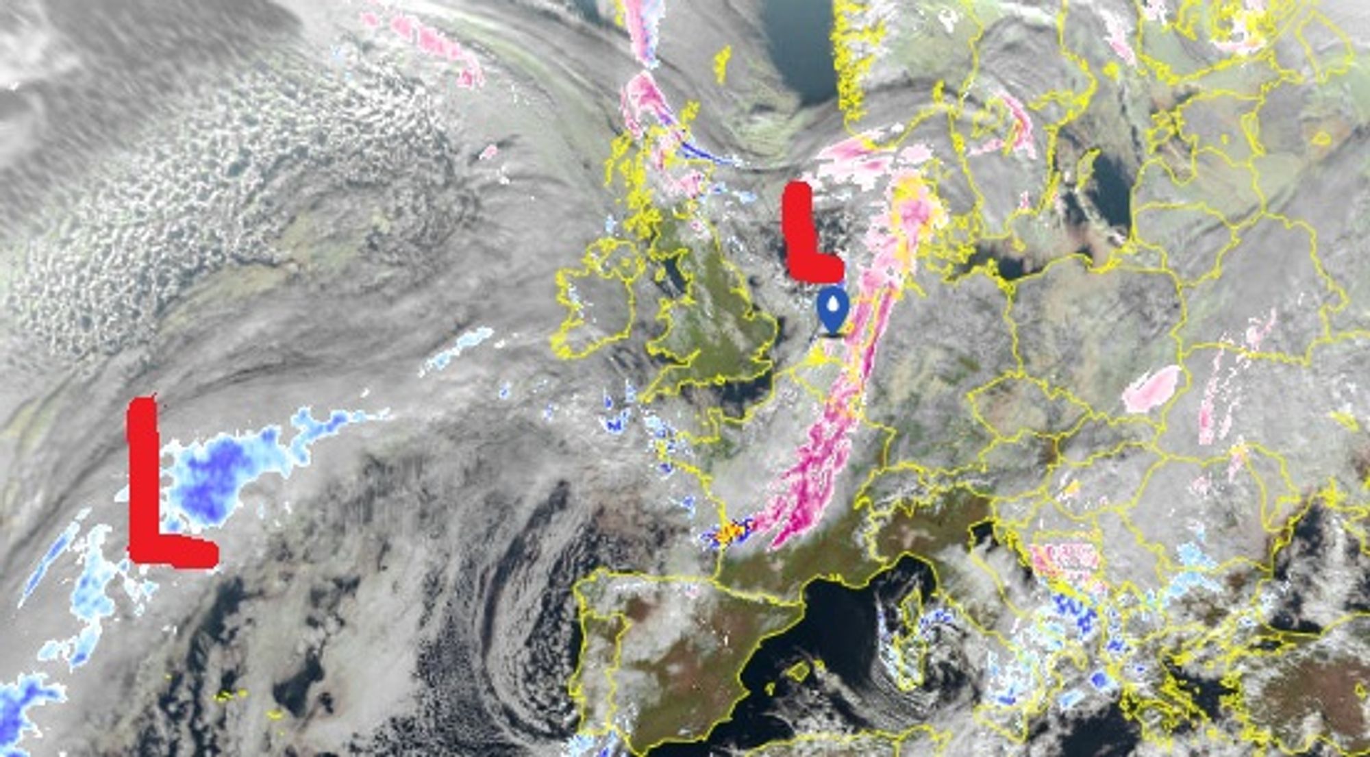
Our focus then shifts to the next low-pressure system, which will deliver PA#3. It is currently barely visible on the weather charts but will develop very rapidly over the next 24 hours. While central pressure is still around 1020 hPa, it is expected to drop sharply to around 970 hPa by Friday morning as the system moves across the Channel and over the Netherlands. This storm depression will bring severe storms to western France, snow to the Alps (with rain temporarily up to 1500 m), and strong winds. Below are the latest insights regarding PA#3 precipitation, divided into three phases.

- 1cm
- 5cm
- 10cm
- 15cm
- 20cm
- 30cm
- 40cm
- 50cm
- 75cm
- 100+
- 1mm
- 5mm
- 10mm
- 20mm
- 30mm
- 60mm
- 120+
The warm front
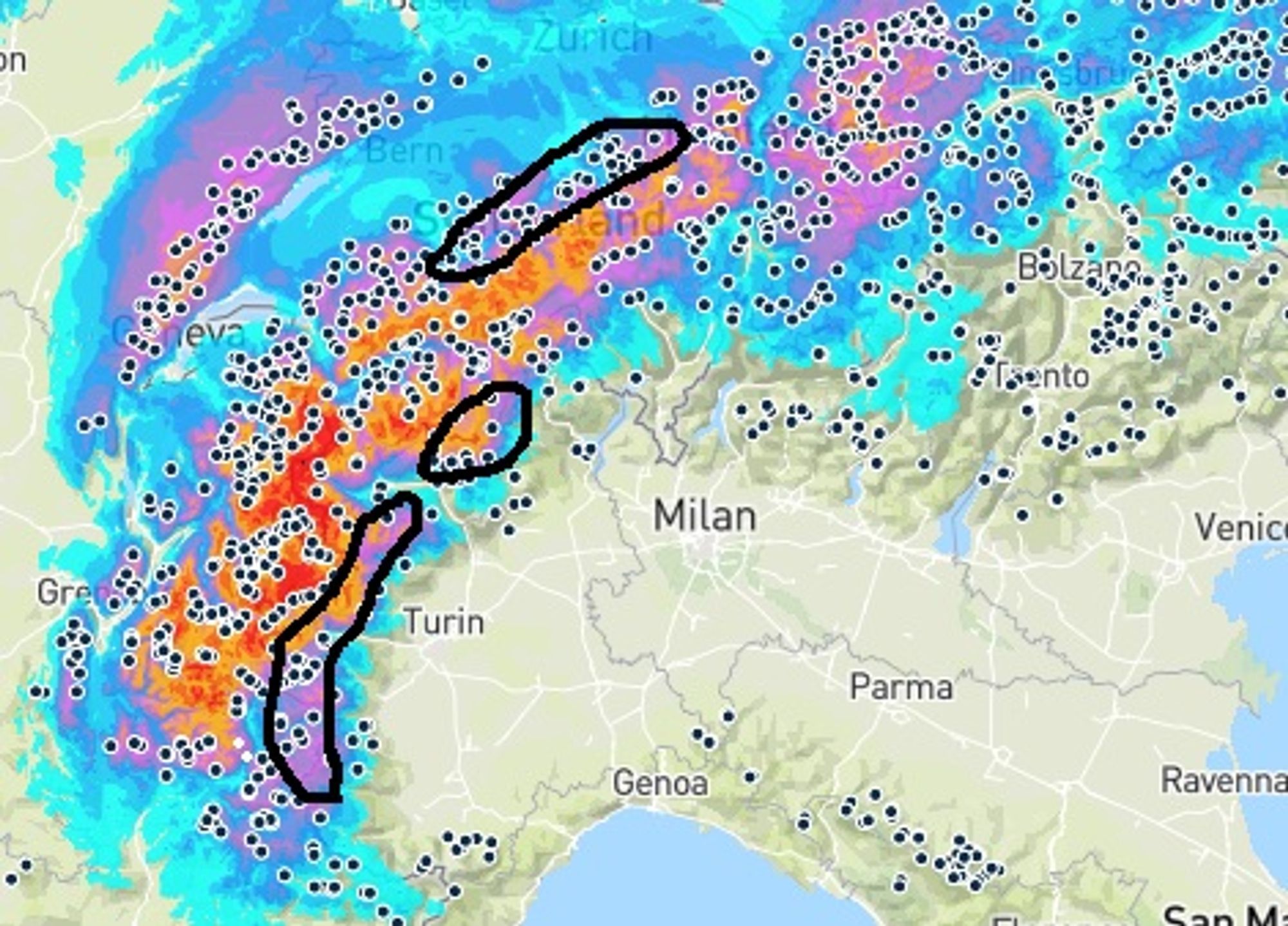
The warm front reaches the Alps from the west on Thursday morning, allowing temperatures to rise moderately. Precipitation focuses on the French Northern Alps and the western Valais. The Écrins form the southwestern boundary; along the main Alpine ridge, amounts gradually decrease eastward into Switzerland, and east of the Arlberg it remains largely dry. Precipitation initially falls as snow down to the valleys but will turn to rain below 1200–1700 m. In the most precipitation-rich regions (around Chamonix), the snow line generally stays below 1500 m. Maximum snowfall totals of 30–40 cm are expected around the Mont Blanc tunnel.
The cold front
The cold front reaches the French Alps late Thursday evening. There will be little to no break in precipitation before activity increases again toward Friday morning, as colder air flows in. The snow line drops toward 700 m on Friday.
The cold front crashes into the Alps, driven by a jet stream aimed directly at the Alpine arc. As a result, precipitation penetrates deep into the massif, given the west–southwesterly flow. Regions such as La Grave, Serre Chevalier and Puy Saint Vincent (FR), as well as Zermatt and Saas-Fee (CH), can expect significant snowfall. Expect wind peaking over 100 km/h on ridges and peaks.
Total snowfall amounts may reach up to 80 cm where both warm and cold fronts are active, 30–50 cm in many other areas, and less in regions lying further south and east in the wake of the main ridges getting hit from the west. Temporary snowfall is also possible on the Italian side (e.g. Via Lattea) and Abriès. Around the Arlberg, up to 20 cm may fall by Friday morning — with less further east. Still not much snow for Austria overall…
Push from the west, later northwest
On Friday, the jet stream continues to blast into the Western Alps, sustaining snowfall even after the cold front has passed. Moist air and orographic lift produce prolonged snowfall, with snow lines around 1000 m, extending far south in the French Alps up to the Swiss main ridge and the Zermatt/Saas-Fee border region.
By Saturday, the flow shifts more toward the northwest, shifting the focus of precipitation to the north-facing stau regions of the French, Swiss, and later also Austrian Northern Alps. An additional 20–40 cm is expected in the French Northern Alps and along the Swiss main ridge, and 10–20 cm in the Austrian Northern Alps, with snow falling down to valley level. Austria should turn dry last, by Sunday morning.
Estimated totals for PA#3:
- 60–100 cm in the French Alps between Écrins and Les Marécottes, locally more
- 15–40 cm in French areas such as Vars and Abriès, possibly also Sestriere (IT)
- 40–80 cm in Valais (including IT border areas) and along the Swiss main ridge
- 30–50 cm in the Arlberg region (AT)
- 10–25 cm in the Austrian Northern Alps, eastward from Tyrol
Warming and precipitation on Monday
By Sunday morning, the last snow showers move out of Austria, while elsewhere conditions are already dry and cold. Strong winds are still expected (especially in the east), along with residual cloud near the northern ridge and increasing high cloud in the west during the day. These clouds are the first signs of a new, more intense warm front, which currently looks set to cross the Alps early on Monday. It will again bring precipitation to the same preferred regions as PA#3 — but unfortunately with a much higher snow line. Especially in the west, prolonged precipitation on Monday with the snow line rising to 2000 m or higher. Further east, precipitation remains snow below 1500 m for longer. Fresh snowfall amounts of around 25 cm are possible at higher elevations. The warmer air does not appear to be pushed out quickly again, although model output becomes highly volatile from mid-next week onward.

- -20°
- -15°
- -10°
- -5°
- 0°
- 5°
- 10°
- 15°
- 20°
Caution advised
Earlier in this update, we already discussed how easily wind slabs formed in the Netherlands. As Henri also wrote yesterday, the combination of strong winds, a thin and weak base, and a significant fresh snowfall is a dangerous one.
There is a considerable chance that avalanche danger will be rated high (level 4) on Friday/Saturday across the entire region between the Écrins and the Arlberg. Already by Thursday evening, avalanche danger in the French Alps rises to level 3.
> Début de l’offensive neigeuse. En fin de journée, les cumuls de neige fraîche associés au vent fort (et aux gobelets en surface) induisent une importante hausse du risque.
Keep a close eye on official avalanche bulletins, e.g. for France and Switzerland
The wePowder Guide also addresses avalanche hazards and wind slabs. If you don’t have it yet, you can order it here
Preferred regions to go?
The obvious question for anyone planning a trip to the Alps is: where to go? My first thoughts go to tree runs and solid base depth. Looking at the last two snowfall events — late December (Piemonte, Monte Rosa) and early January (cold northerly 10–40 cm) — certain regions seem to overlap the current PA#3. These include the French Queyras (Abriès), the Swiss side of the Monte Rosa massif (Saas-Fee) which received snow around Christmas, possibly Via Lattea, and Swiss areas such as Engelberg, which picked up 10–30 cm in early January. Arlberg region might also be a fit but the real dump arrives later and is less certain.
Areas with overlap might have a relatively better base but highest snowfall is expected further west and north. Given the approaching warm front on Monday, areas that receive sufficient snowfall from the cold front on Friday seem preferable, allowing Saturday and Sunday as ski days without warm-front influence. Wherever you go: choose defensive lines <30 degrees, stay in forested terrain where possible, especially on west- and north-facing slopes with a base, and don’t be surprised if lifts remain closed due to wind and/or avalanche danger.
Also more snow Belgium and German regions
After today’s snowfall, the deepening storm system brings a gradual warming over the next two days. Toward Friday, a narrow warm sector introduces rain in the Benelux countries and parts of Germany, but from Friday afternoon onward, temperatures drop again and precipitation may quickly turn back to snow.
The low mountain ranges in Germany and Belgium already have a decent snowpack. After some rain and melting on Friday, the weekend could turn out surprisingly well. I expect melting to remain limited in places like the Sauerland, while especially in the Ardennes, areas above 300–400 m could pick up another 10–25 cm of fresh snow Friday. And cold temperatures will hold until after the weekend following this snow spell. We’ll keep a close eye on this in upcoming updates.
Replies
Interesting update!
What is your view on the Mont Blanc/Chamonix area after Monday? Will there be a sufficient base above 1500m despite the higher snowline on Monday?
Expecting some base to remain but snow will be wet/heavy (and higher temps might stick for several days).
Whats your thoughts on the vorarlberg region? Looks like plenty of snow in the coming week.
Expecting some base to remain but snow will be wet/heavy (and higher temps might stick for several days).
CVS - 07 Jan 2026 21:39
Sad to hear… Looking at the forecast, the precipitation amounts seem quite high on Monday. No chance for dynamic cooling ? 😅
Whats your thoughts on the vorarlberg region? Looks like plenty of snow in the coming week.
Pow123 - 07 Jan 2026 21:51
Indeed enough snow in the FCST. Hardly ever disappoints it seems; expect biggest dump between early Saturday and early Sunday.
Expecting some base to remain but snow will be wet/heavy (and higher temps might stick for several days).
CVS - 07 Jan 2026 21:39
Sad to hear… Looking at the forecast, the precipitation amounts seem quite high on Monday. No chance for dynamic cooling ? 😅
Benja - 07 Jan 2026 22:05
Latest models do not agree on strenght and amount of precip. Also some models tend to delay a bit. Dynamic cooling depends on intensity and will happen but doubt it will be sufficient if the warm air reaches +4/5 at H850…
Will be looked at in next update later today.
Regarding Vorarlberg: Yes, looks like up to 30cm fresh snow since today till Sunday midday on 2000m.