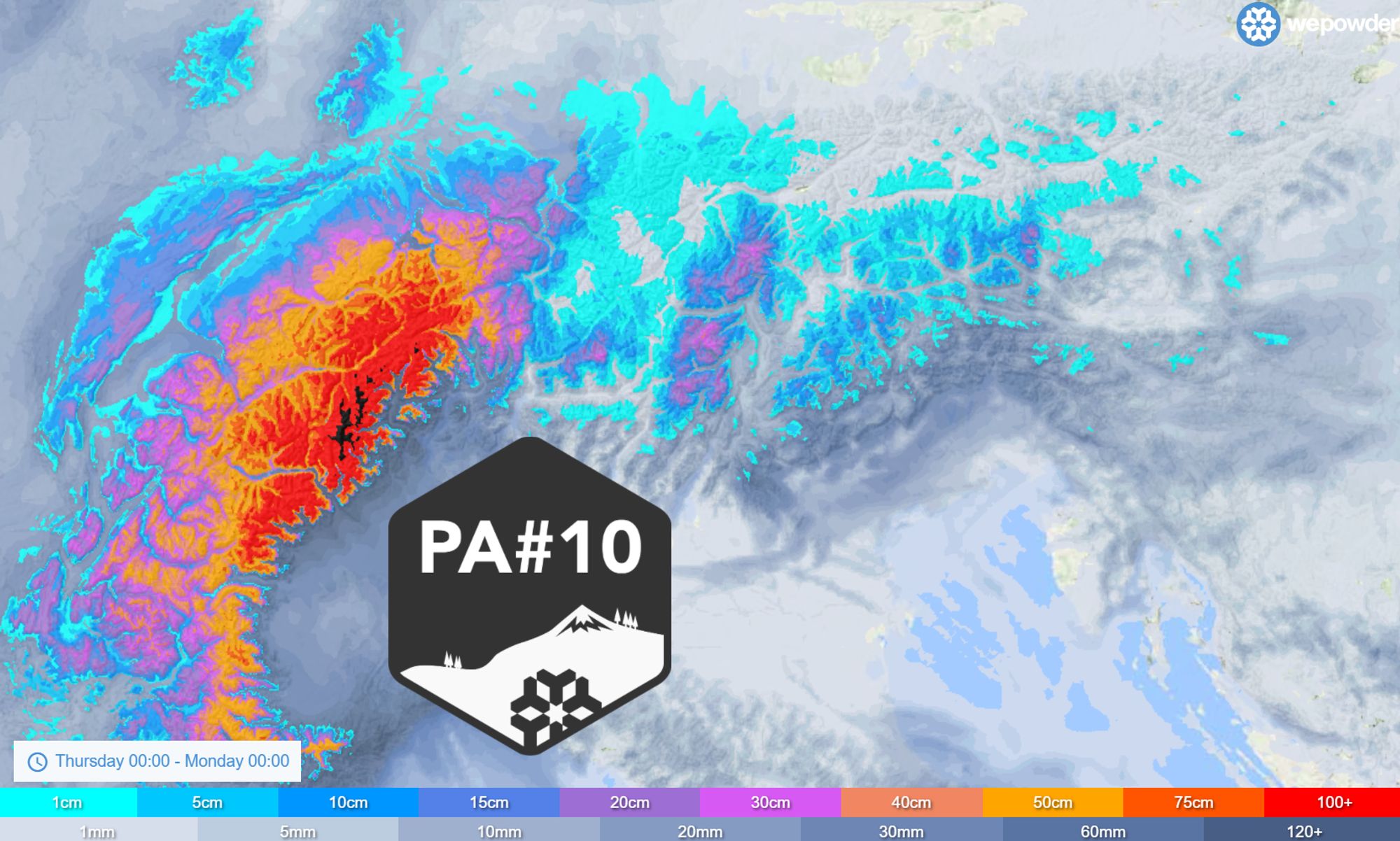
After three weeks without a new PowderAlert, it’s finally happening again. PA#10 will bring fresh snow from Saturday night onward to Piemonte, Aosta, and southern and central Switzerland, with 30-50 cm in many places and locally more than a meter of snow.
Synoptic Situation
Coen already clearly described the situation yesterday. You can reread his forecast here. By now, the weather models are more aligned. The upcoming snowfall will be caused by a trough moving into the Alps from the west. Ahead of this system, a southerly flow develops toward the southern side of the Alps, creating a southerly orographic lift (Südstau) in Ticino. At the same time, a front arriving from the west reaches the French Alps.
As the system develops further, a cut-off low forms in the upper atmosphere, concentrating precipitation mainly over Piemonte, eastern Aosta, Ticino, and along the Swiss main Alpine ridge. This could temporarily even create a retour d’Est-like setup, bringing prolonged snowfall to Piemonte and Aosta.
Large snowfall amounts
The cold front will reach the Western Alps during the course of Saturday. The snowline will drop here from around 1500 meters to quickly (well) below 1000 meters. In many places in the French Northern Alps and Valais/Vaud I expect 20 to 30 centimeters of snow, locally even up to 40 centimeters. The French Southern Alps will generally see around 20-30 centimeters, with higher amounts toward the Italian border.
On the Italian southern side of the Alps, especially in Piemonte, the Aosta Monte Rosa region and Ticino, the largest snowfall totals are expected. Due to a southerly to southeasterly flow, snowfall may persist here longer, through Sunday. Around half a meter of fresh snow is expected across a wide area, and up to a meter in the hotspots. Locally, even up to 1.5 meters in the hotspots (eastern Aosta to western Ticino) cannot be ruled out. Snow will also temporarily extend across the Swiss main Alpine ridge toward Central Switzerland, where 30 to 60 centimeters are possible, for example around Andermatt and Disentis. This is also clearly visible in our forecast.
Across the entire southern region the snowline will generally be somewhat higher, between 1000 and 1200 meters, though temporarily lower levels in the hotspots are certainly not out of the question. Due to precipitation cooling during periods of high intensity, snowfall there could potentially reach the valley floors.

- 0-2 bft
- 3-5 bft
- 6 bft
- 7 bft
- 8 bft
- 9 bft
- 10 bft
- 11 bft
- 12 bft
The wind does not appear to become a very major issue, but it will still be quite windy. First on Friday on the northern side due to the föhn. With the front, the wind will turn to the west, and at higher elevations to the southwest/south, and strong gusts may occur in the high mountains, which will cause some snow transport during the snowfall. Especially the French Alps, the Alpi Marittime and areas around Ticino may temporarily experience this strengthening wind, but overall it is not expected to become stormy.
Snow for Austria from Sunday evening
The front will not move further east, meaning the Eastern Alps will hardly benefit from this snowfall. Around the Dolomites, in the slightly milder air, it will likely mainly remain limited to a few snow showers during the day over the weekend. On Sunday, high-pressure influence from the west increases and the remaining snowfall in Piemonte and surrounding areas will weaken. A weak front reaches Austria during the night into Monday. This will not bring more than 5-10 centimeters, but on Monday a weak northerly orographic flow will persist, with snow showers that could regionally bring another 10-20 cm of snow. The snowline will mostly lie just below 1000 meters. However, do not focus too strictly on these amounts, as they may still change in the coming days.
Where to go?
Next, a short look at the where-to-go question. Saturday is still a bit ‘early’, so don’t expect full-on powder yet. During the day it will snow heavily in the Western Alps and visibility at higher elevations will be poor. Therefore, try to look for areas that already have a good base with higher-elevation tree runs. From Sunday onwards, more will be possible, also at lower elevations. In Piemonte and surrounding areas snowfall will continue, while in the French Alps and Valais (except for the border regions with Italy) it may clear up somewhat more. Monday is then a day to focus on the areas around the hotspots of this snow phase. With the very high totals, resorts right in the core hotspots such as San Domenico may have difficulty opening lifts, so try to look a bit more toward the edges of the main hotspots where more than enough snow will also fall. Areas such as Monte Rosa will be an interesting option.
Southern Piemonte will also see good totals, but the snow there may be somewhat heavier. Sunday would likely be the right day there; Monday will bring more sunshine but it will quickly become very mild. It may therefore be better to focus on the regions further north. By Tuesday it will become milder everywhere in the Western Alps, meaning you will have to look for higher elevations. Chris will go into this in more detail in a new forecast tomorrow.
Avalanche Danger
With the large amounts of fresh snow combined with the wind, avalanche danger will rise sharply. During the course of the weekend we can expect avalanche danger level 4 in parts of Switzerland, France and the western half of the Italian Alps. As always: check the avalanche bulletins before heading out!