The word jet stream (and polar vortex) is appearing more and more often, including in my weather reports. For most people, the jet stream probably sounds familiar, but it is a particularly interesting topic to discuss in some detail. How is it possible that a wind system at the very top of the troposphere at about 10 kilometres altitude is so important for the (winter) weather in the Alps? In this background article, I will try to answer the following questions:
- What is the jet stream?
- Are there different jet streams?
- How is a jet stream formed?
- Why is the jet stream important?
- How does the jet stream affect Alpine weather?
- Does the jet stream change?
What is a jet stream?
^Tailwind
The jet stream is also the reason why planes from North America to Europe are usually much faster than the reverse route. Due to extreme wind speeds in the jet stream, a new record time was set in February 2020. A flight from New York arrived in London within 5 hours, which normally takes about an hour and a half longer.
The jet stream is a band with extremely high wind speeds in the upper troposphere at about 10 kilometres altitude. Speeds of over 100 kilometres per hour are measured, with wind speeds sometimes exceeding 300 kilometres per hour. The jet stream is several kilometres thick, up to several hundred kilometres wide, and it can often be several thousand kilometres long. You can find a great visualisation of the jet streams on the website earth.nullschool.net.
Different jet streams
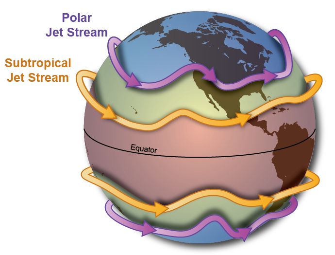
In order to avoid confusion, it is important to mention that when talking about jet streams, there are often several different jets that are mixed up. First of all, there is a subtropical jet stream at about 30 degrees north latitude and a polar jet stream at about 60 degrees north latitude. The polar jet stream is the most important for winter weather in the Alps.
There are two different polar jet streams: one lies in the stratosphere at around 30 kilometres altitude (10 hPa) and the other in the upper troposphere at around 8 to 10 kilometres altitude (300 hPa). Although the stratospheric polar vortex can certainly also influence the weather at our latitudes (e.g. through a sudden stratospheric warming event), in this article we focus first on the tropospheric jet stream. Cold outbreaks in the Alps are mainly linked to local deviations of the tropospheric jet stream. In the last part, I will take a closer look at the polar vortex in the stratosphere.
How does the polar jet stream occur?
The formation of the polar jet stream has everything to do with the uneven distribution of solar radiation on Earth. While the high energy input of the sun cause the tropics to warm up strongly, the sun is much lower in the sky in the polar regions, so it remains colder there. This differential warming is the driver of several air movements, including the polar jet stream in the troposphere around our latitude.
If the Earth stood still, these temperature differences would be cancelled out by a direct southerly flow from the tropics to the North Pole, but due to the Earth’s rotation (and the additional Coriolis effect), this flow is deflected to the right in the northern hemisphere. Therefore, the jet stream runs from west to east. The jet stream forms the boundary (the polar front) between warm air from the south and cold polar air from the north and acts as a conveyor belt for depressions. The greater the temperature difference, the stronger the jet stream.
^Thermal wind
The wind speed increases with altitude with a peak at about 8 to 12 kilometres altitude, right at the top of the troposphere. In meteorology, we explain this with the term thermal wind. The temperature gradient causes the wind speed to increase sharply with altitude.
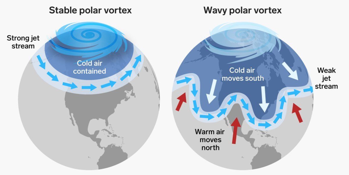
It is rare for the jet stream to be perfectly zonal (from west to east); the rough surface of the earth can cause it to meander. The meandering causes so-called ridges and troughs in the jet stream. A trough is when the jet stream sinks to the south and a ridge is when the jet stream meanders to the north. It is these ridges and troughs that make our weather so changeable. Low-pressure areas can develop under troughs, while high-pressure areas can create good weather near ridges. The jet stream, with its high and low pressure areas, is the driving factor of the weather at our latitude.
The impact of the jet stream on the weather in the Alps
In the winter, polar regions receive no sunlight at all, which can cause it to cool off considerably. In the tropical regions, on the other hand, the sun’s energy input remains fairly constant. The previously mentioned temperature difference between higher latitudes and the tropics is therefore even greater. In winter, the jet stream is therefore much further south than in summer. In addition, the large temperature differences make the jet stream stronger, which makes it a particularly influential factor for winter weather in the Alps.
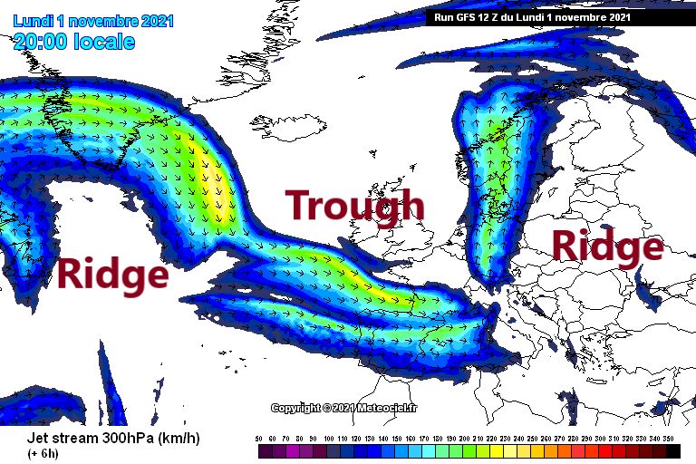
If the jet stream is far to the north, the Alps are in the warm sector and there is hardly any chance of winter weather. A more southerly location of the jet stream opens up opportunities for cold winter weather. If the Alps are fully in the line of fire of the zonal jet stream, the Western Alps in particular will have to deal with a succession of precipitation fronts with generally strong winds and fluctuating temperatures. If the jet stream is more meandering, the other parts of the Alps will also be able to enjoy precipitation. I have illustrated two examples for a Nordstau- and a Südstausituation with the help of the maps below.
")
")
Changes in the jet stream
So what about climate change and the jet stream? It’s a question which is not so easy to answer. On the one hand, slowing down the jet stream may cause it to meander more. The slowdown can be caused by the arctic region warming up very rapidly, the so-called Arctic amplification. As the temperature difference between the Arctic and the tropics is considerably reduced as a result, the jet stream can become weaker and more meandering. More extreme and persistent weather can occur as a result of more persistent blockages. Both prolonged drought and heat as well as a solid cold period with considerable snowfall are possible.
On the other hand, climate change is also causing the upper parts of the tropical troposphere to get warmer, which could in turn strengthen the jet stream and cause it to shift further north. However, much remains unclear. Which of the two different processes is dominant and what are the differences per region and per season are two of the many questions that has not been answered yet.
Extra: Stratospheric Polar Vortex and Sudden Stratospheric Warming
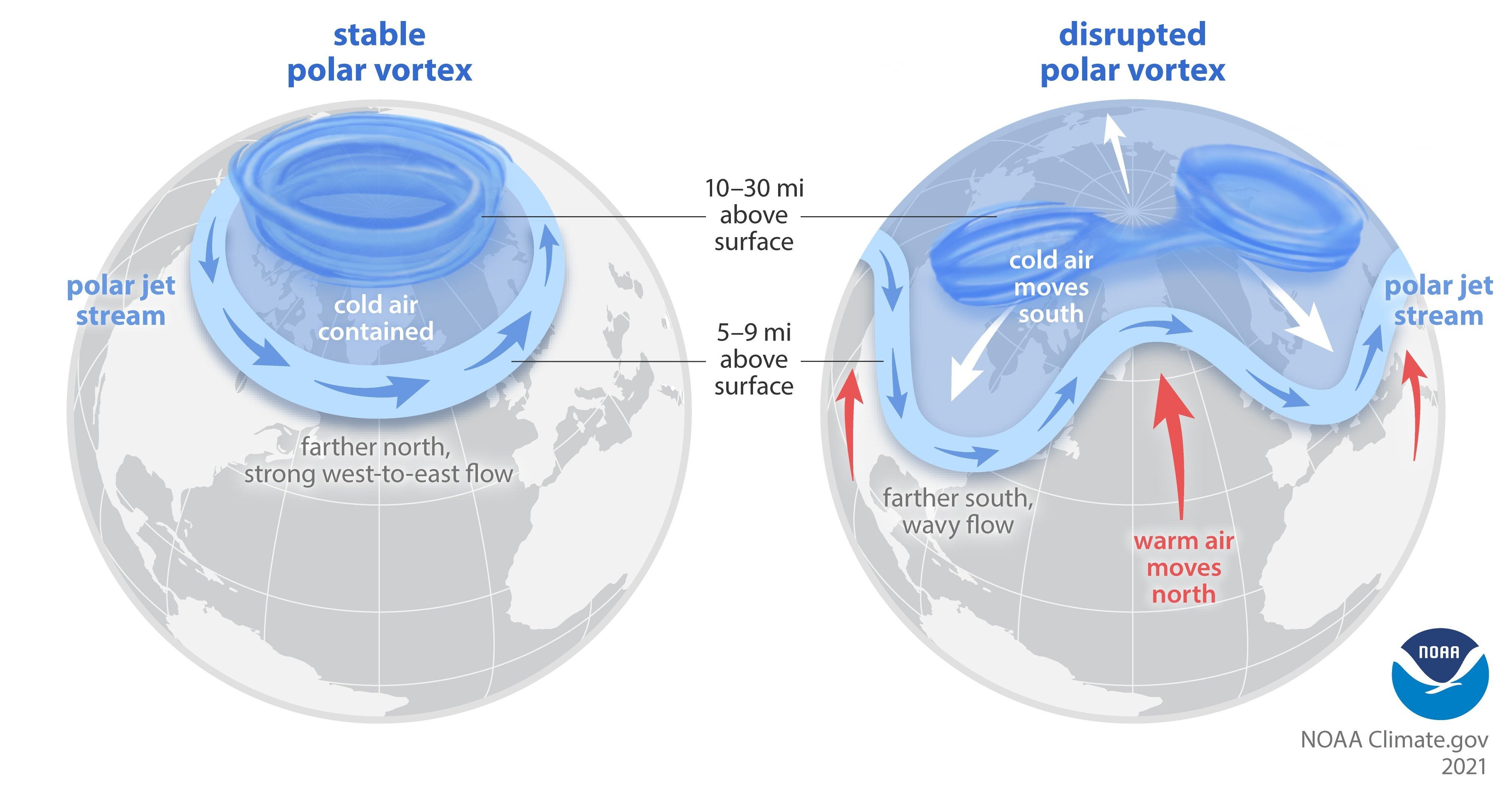
I have now only discussed the tropospheric jet stream, but as I said earlier, certain weather situations such as a cold air outbreak can also be linked to changes in the stratospheric polar vortex. The stratospheric vortex at high altitude is hardly influenced by the earth’s surface and therefore usually runs in a nice circular or elliptical pattern around the North Pole. A strong polar vortex means that the cold air is trapped in the arctic regions. However, this polar vortex can sometimes be disrupted, especially by a so-called Sudden Stratospheric Warming (SSW).
The process is quite complex, but the cause of this rapid warming often lies in the troposphere, where energy from strong weather systems can propagate vertically. This energy can disturb the balance of the polar vortex in the stratosphere to such an extent that it can split in two. The cores of the polar vortex are then forced to descend to lower latitudes.
A disrupted stratospheric polar vortex could, with a delay of a few weeks, cause the jet stream in the troposphere to meander more, which could increase the chances of winter weather in the Alps. It must be said, however, that this is by no means always the case. It is difficult to know in advance exactly what impact such a warming at 30 kilometres altitude will have on the weather at the Earth’s surface. Everything still has to fall into place for a real winter to occur. It may well be that the Alps will be under the influence of a ridge of the meandering jet stream for a long time, which may ultimately produce warm and dry conditions.
Read also:
Reference: Stendel, M., Francis, J., White, R., Williams, P., Woollings, T. (2021). The jet stream and climate change.
Replies
Very well written and instructive article. Thank you.