
The weather is largely determined by the location of high and low-pressure areas. It is well known to everyone that for fresh snow in the Alps we need a situation with a low-pressure area which is at least nearby. With a steady high-pressure area over the Alps, we won’t expect any fresh snow. To delve a little deeper into the different situations that give snow in the Alps (e.g. a nordstau or a südstau), I would first like to explore what, exactly, high and low pressure areas are. In this background article, I will try to answer the following questions:
- How do high and low pressure areas form?
- What types of high and low pressure areas exist?
- How do winds flow around high and low pressure areas?
- How do you recognise high and low pressure areas on a weather map?

Energy from the sun
The engine of Earth’s weather is the sun. The uneven distribution of incoming solar radiation causes temperature differences between the equator and the poles. The tropical regions can heat up strongly due to high energy input from the sun. In the polar regions, the angle of the incoming solar radiation is much smaller, causing the same energy to be distributed over a larger surface area and thus cooler temperatures. This differential warming creates air currents in the atmosphere.
If the earth did not rotate, this temperature difference would be cancelled out by a southerly flow from the tropics to the north pole (and conversely a northerly flow from the tropics to the south pole), but the earth’s rotation deflects this flow to the right in the northern hemisphere. This is known as the Coriolis effect.
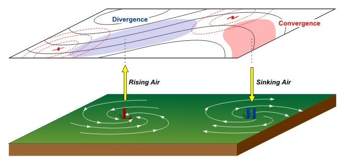
The flow from a high-pressure area to a low-pressure area also deflects the wind. Without the earth’s rotation, the wind would blow directly from a high-pressure area to a low-pressure area, but due to the Coriolis effect, the wind in the northern hemisphere is deflected to the right. This causes counterclockwise spiralling around a low-pressure area and clockwise spiralling around a high-pressure area. The website earth.nullschool.net shows these counterclockwise and clockwise spiralling around pressure cores.
How do high-pressure areas form?
Differences in temperature are thus responsible for air currents and weather at our place. In winter, these temperature differences between lower and higher latitudes are greater than in summer, making this also the season of storms that can form. High- and low-pressure areas can arise through both thermal and dynamic processes. Thermal high-pressure areas often form over land in places where it gets really cold in winter. The cold and therefore heavy air is denser and so high pressure prevails here. In winter, you find some semi-permanent high-pressure areas, for example over Russia and Greenland.
The development of a dynamic high-pressure area happens when there is confluence of air higher up in the troposphere. The confluence creates subsidence, which is nothing but descending air movement. During this descending movement, compression allows the air to warm up and dry out, often making it nice and sunny in the mountains (but not always and everywhere!). However, an inversion can occur in the valleys. More on this follows in its own article on inversions.
How do low-pressure areas form?
Low-pressure areas (depressions) are formed partly due to strong warming. The air expands, becomes lighter and begins to rise. Air pressure drops and a low-pressure area may form. This type of low pressure area is called a thermal low. These low-pressure areas often form in summer above the land surface and around the equator.
The low-pressure areas that also develop in winter at our latitude and are therefore more interesting to us, develop on the polar front (and are therefore called frontal depressions). You can read more in the article on the jet stream. Here at the boundary of the two vastly different air masses, small disturbances (waves) can develop. Sometimes these disturbances disappear again, but usually they can develop further into low-pressure areas several hundred kilometres in size (see image). This happens when the jet stream at the top of the troposphere is well developed. The depression can develop over the ocean and are brought to Europe by the jet stream. This process of cyclogenesis creates fronts. More on weather fronts will follow soon in a separate background article.

In addition, due to the presence of a mountain range, there is another way of forming a region with low-pressure, called orographic depressions. When a flow is impinging the mountain range, a region of high pressure is formed on the windward side and a low pressure area on the leeward side. This kind of orographic depression can form on the southern side of the Alps, especially during nordstau conditions. Thermal influences such as a warm Mediterranean Sea can cause this low pressure area to strengthen.
Finally, you also have polar low pressure areas (polar lows), which can form in winter. The cold polar air over (snow- or ice-covered) land surface can collide with the significantly warmer air over the (ice-free) ocean. The boundary between these two very different air masses is called the arctic front. A polar low is therefore a kind of frontal depression, so to speak. A polar low is short-lived, but can be quite intense with a lot of snow. In Europe, polar lows have most influence in Scandinavia; the Alps are often too far inland and too far to the south.
Upper-level low
Besides these types of low-pressure areas, we also regularly encounter an upper-level low. This is a bubble of cold air in the upper air layers, with significantly warmer air below. The sneaky thing about a high layer is that you cannot recognise it on weather maps like the one below, which only indicate pressure at sea level. The large temperature difference can cause quite a lot of vertical movement and therefore quite a lot of precipitation. Determining the course of a high pressure layer is quite a challenge for meteorologists. The low-pressure area can remain in one place for a long time and thus cause (enormous) flooding locally. The recent upper-level low called Bernd in July 2021 with its catastrophic flooding in the Ahrtal valley is a good example of this, but also upper-level lows over the Mediterranean can often (especially in autumn over the warm waters of the Mediterranean) cause very high precipitation.
So, to conclude, all low-pressure areas are accompanied by rising movements, allowing cloud formation and precipitation to take place here. If we want to see serious snowfall in the Alps, we really need a low-pressure area at least nearby.
")
 with low- and high-pressure systems and fronts (wetter3.de, DWD)")
Weather map
The weather map shows all high and low pressure areas marked. High-pressure areas are indicated with an H, low-pressure areas with an L (or T in German from the word “Tief”). The lines you see are isobars (lines of equal pressure). Higher up, the wind blows parallel to the isobars. At the surface, the wind deviates slightly in the direction of the low pressure area due to the increasing influence of friction.
Low-pressure systems usually approach Europe from the west. The greater the difference in air pressure between a high and low pressure area, the stronger the winds. You can see this on the weather maps by the isobars lying close together. If the isobars are far apart, the wind will be weak on a large scale. A small sidenote: in the mountains, even during these weak wind conditions, local thermal winds can still develop and can get quite strong.
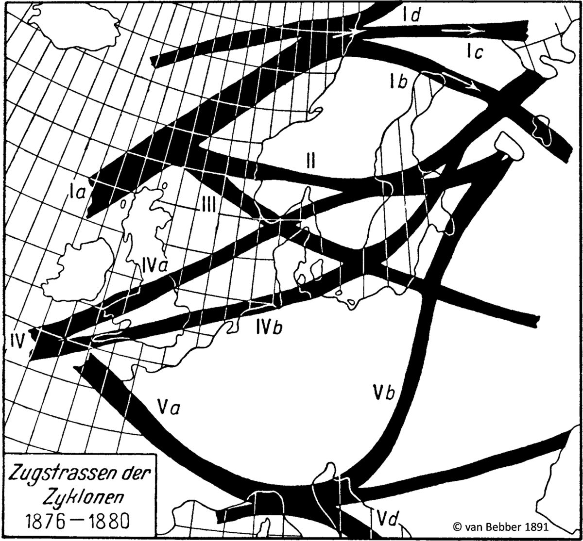
Track of low-pressure systems in Europe
Van Bebber identified typical low-pressure system paths over Europe as early as the 19th century. Here you can immediately see that many of the depressions move from west to east, but that there are also very many variants. For us in central Europe, the western circulation is a common weather setting, dominated by the high-pressure area over the Azores and a strong low-pressure area around Iceland. In other background articles (e.g. on the nordstau and südstau), I’m highlighting the different weather settings and their impact on the weather in the Alps, for example the so-called Five-B weather situation (Vb-Wetterlage), which is very interesting for the Alps.