The retour d’Est is one of the fascinating snow events for the Alps with often staggering amounts of snow in a short time. One or even two metres of snow within a day or two can happen with a proper retour d’Est. It’s time to explain what processes cause these excessive snowfall events. In this article I answer the questions:
- What is a retour d’Est?
- What are the necessary ingredients for a retour d’Est?
- Why is a retour d’Est often so intense?
- Which regions benefit from a retour d’Est?
- What are the pitfalls of a retour d’Est?
In a nutshell: what is a retour d’Est?
A retour d’Est literally means “return from the east”, so the weather phenomenon has to do with an easterly flow. A depression over the Mediterranean can, in certain cases, create an easterly flow over the Po Valley. This flow then bumps into the north-south facing Western Alps and is forced to rise. This can cause particularly heavy snowfall in Piedmont and some other regions.
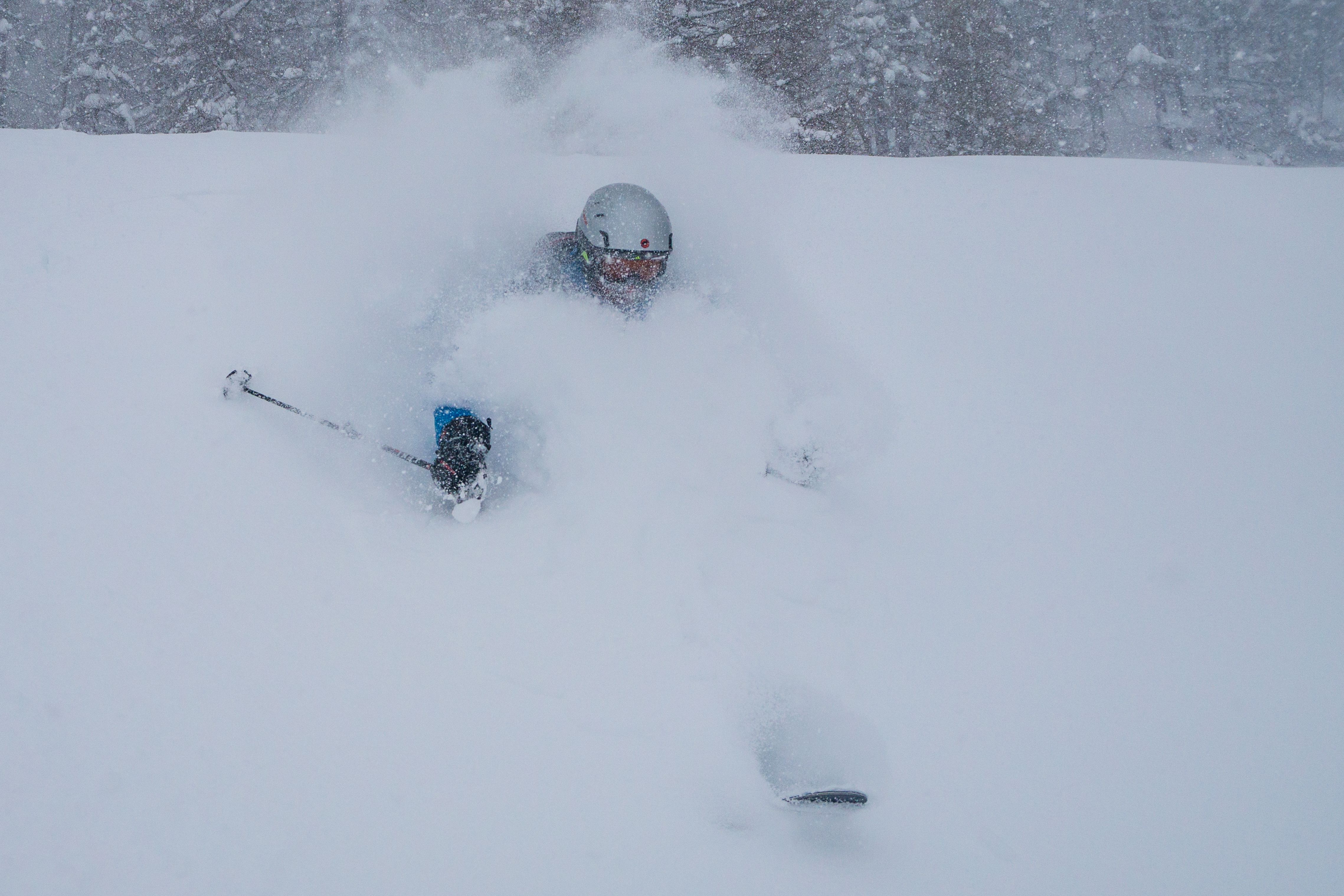
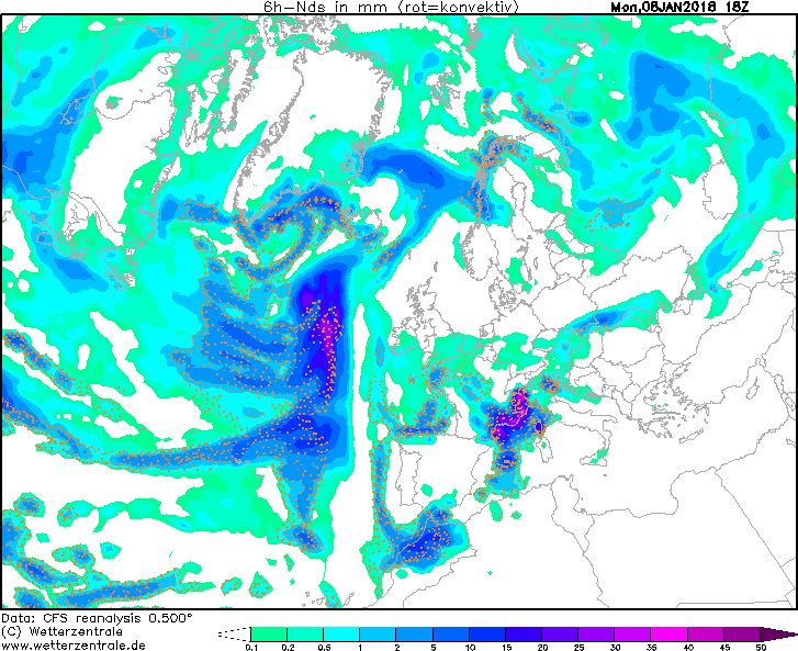
The phenomenon occurs only a few times a year, but when we are experiencing a retour d’Est event, we see extremely bright colours on our snow forecast. The weather situation creates one of the fiercest precipitation intensities in the Alps with sometimes as much as one to two metres of snow within 24 hours. Check out our liveblog during the extreme retour d’Est of January 2018
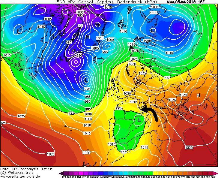
Genoa Low
For a retour d’Est, everything really needs to fall into place, with two ingredients being essential: an easterly wind and a moist air mass. First of all, we need a depression in the proximity of the Gulf of Genoa (hence the name Genoa Low). In my background article on low-pressure areas, you have seen that air around a low-pressure area rotates counterclockwise. In this setting, the flow can pick up a lot of moisture over the (relatively warm) Adriatic Sea. In some cases we will observe an easterly flow over the Po Valley. We cannot say that a high-pressure area necessarily needs to be in a certain place, but high pressure north/east of the Alps (such as a Scandinavian high) is favourable.
If we look at the shape of the Alps, we can see why a retour d’Est is able to create such large amounts of precipitation. In the image below, you can see that the eastern flow has no really obstacles over the flat Po Valley, it can flow westwards without too much trouble. Over Piedmont, it suddenly bumps into a huge natural barrier: the western Alpine arc. Trapped in a bowl, the moist air can only go in one direction: up! This upward movement allows the air to cool. Condensation and cloud formation will occur. When the air is moist (this is often the case), it starts to snow massively in the mountain areas (orographic precipitation).


From flat to high mountains in just a few kilometres
So why do we observe these excessive precipitation amounts here? A major factor is the sharp boundary between the Po Plain and the high mountains to its west. Unlike many other parts of the Alps where the Alpine foreland consists of gradually rising hills and mountains, the transition here is quite sudden. This ensures that air masses driven into this corner of the Alps must rise abruptly and very quickly. If these air masses have already been able to pick up quite a bit of moisture over the Mediterranean, you can imagine that precipitation amounts will be very high.
The snowline of a retour d’Est depends largely on how warm the incoming air mass is. With a maritime origin, the snowline, especially in autumn, can still be fairly high. In winter, a cold pool can often form over the Po Valley. These cold pools close to the surface persist for a fairly long time in the Po Valley. They are more or less enclosed by the arch shape of the Alps and cannot easily dissolve. With an approaching low-pressure area over the Mediterranean, the warmer maritime air is pushed over this colder surface layer. This pushing of moist air masses over the cold surface layer can cause snow to fall into the lowest valleys.
Another possibility for snowfall from the east could occur with a cold outbreak in the Alps, creating flow around the eastern Alps and easterlies over the Po Valley. Although you maybe wouldn’t expect snow in this case with the high air pressure (colder air), some orographic snowfall can still occur. However, as this continental air from the east is usually quite dry, precipitation amounts remain small. So not every easterly wind over the Po Valley is a retour d’Est!
Which regions benefit from a retour d’Est?
Which regions benefit the most from a retour d’Est depends on the small details, the region with the heaviest precipitation is not always in the same place. However, we can say that usually a large part of Piedmont benefits optimally from a retour d’Est, think of hotspots like Prali, Limone Piemonte, Bardonecchia and Sestrière, but also in the French Alps there are some regions that will receive huge amounts. Think of the regions close to the Italian border, such as the Queyras (especially Haut-Guil) and La Haute Maurienne Vanoise, but also Montgenèvre. The further east, the more these areas will benefit. For these areas, the retour d’Est is often the main source of snow in a winter. Precipitation from low-pressure areas from the west or south-west is stopped by the surrounding mountain barriers (e.g. Ecrins). Even within these relatively small regions like Maurienne and Queyras, the differences from west to east can be huge! Due to descending air movements and the föhn effect, it can clear up just a few kilometres west of the main ridge here. This föhn wind is called the Lombarde and ensures dry conditions in the rest of the French Alps.
With a slightly more south-easterly flow, the region with the heaviest snowfall shifts more to the north and areas like Monte Rosa and Macugnaga can benefit considerably. Also a small part of the Swiss Alps (e.g. Zermatt, Saas-Fee) can then expect quite a bit of fresh snow.
Pitfalls of a retour d’Est
There are a number of pitfalls that come with a retour d’Est, which is why we rarely see this phenomenon. This is because a Genoa Low alone is most of the times not enough. The wind really needs to have an easterly component. A Genoa Low often gives a southerly or southwesterly flow, giving large amounts of snow to the rest of the southern Alps and not to Piedmont. In addition, the low pressure area should not pass too quickly. Otherwise, the easterlies will terminate too quickly, causing less orographic precipitation and disappointing snow amounts.
All in all, there are plenty of factors that can throw a spanner in the works. Predicting a retour d’Est is often very tricky too. Small differences in the Genoa Low could mean that a retour d’Est will disappear from the charts. Of course, it can also be the other way round: a retour d’Est can pop up on the weather charts quite suddenly.