The Südstau (Süd = south, stau = orographic lift) is one of the words we are all happy to see in the weather reports on wePowder. The Südstau is known as a potential snow bomb, yet there is a lot involved in getting classic Südstau situations like the one in December 2020. In this background article, I try to answer the following questions about a Südstau:
- How does a Südstau form?
- Is every Südstau the same?
- What does a Südstau mean for the weather in the rest of the Alps?
- How can you recognise a Südstau on the weather maps?
I also describe the ingredients for a classic Südstau situation, introduce the so-called convergence zones in the southern Alps and talk some more about the pitfalls of a Südstau.
How does a Südstau form?
Similar to the Nordstau, a Südstau involves air masses being pushed against the Alps. During a Südstau, these air masses come from the south. The mountain range forms a natural obstacle, forcing the air to rise. This rise causes the air mass to cool and condensation occurs. More and more dense clouds can develop, eventually causing precipitation. How much rain or snow this produces, depends on the shape and height of the mountains, the wind speed and the humidity of the air mass when it hits the mountains.
Unlike the Nordstau where humid air masses are not always as abundant, the Südstau often has good chances of producing a large amount of precipitation due to its proximity to the Mediterranean. The southern flow can pick up a huge amount of moisture as it travels over the sea (especially when the sea surface is still quite warm).
Ingredients for a Südstau
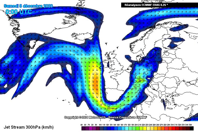
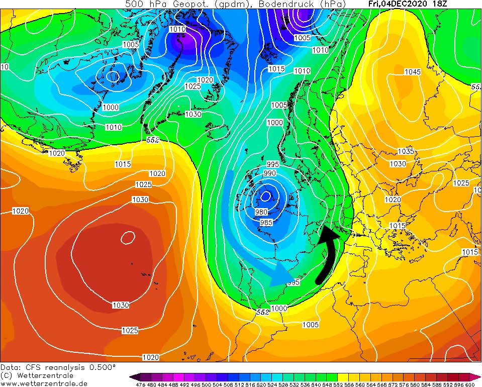
What do we need for a Südstau? First of all, we need a depression close to Central Europe for the supply of polar air. We often see a situation with a strong low-pressure area over the British Isles or slightly further south and high pressure to the east of the Alps. In this case, the jet stream lies a lot further south than the normal zonal (west-east) pattern over Central-Europe.
In this setting, it is possible that a small low-pressure area could form over the Mediterranean as cold air is pushed between the Alps and the Pyrenees/Massif Central and ends up over the relatively warm Mediterranean Sea. This low pressure area is the well-known Genoa Low. The development of this low pressure area over the Mediterranean Sea puts the southern Alps in a moist southern flow. The large amounts of moisture in this flow are picked up over the Mediterranean and because of the orographic lift it can snow a lot in the southern Alps.
Variations
Of course, not every Südstau is the same. Depending on the prevailing flow, you will see some differences. For instance, with a slightly more south-easterly flow, a cold pool close to the surface in the Po Valley may persist for a fairly long time. This cold pool is more or less enclosed by the arc shape of the Alps and cannot easily dissolve. With an approaching low-pressure area over the Mediterranean, the warmer and moist upper-level flow is pushed over this colder surface layer. This pushing of the moist air mass over the cold front could potentially cause (very) large amounts of precipitation. If we are dealing with a more or less stationary Genoa depression, this could create a retour d’est where the easterly winds over the Po Plain blow onto the Italian Western Alps (Piedmont), resulting in large amounts of snow. There will be more on the retour d’est phenomenon in a separate article. If the flow comes too much from the southwest, parts of the French southern Alps can actually benefit much more, and Piedmont would see significantly less precipitation.
")

Hotspots and convergence zones
Why do certain areas in the southern Alps (almost always) receive more rainfall than the rest of the regions? This is due to the fact that there are some known convergence zones in the southern Alps like Ticino and the Julian Alps. At these locations winds from different angles converge due to the shape of the Alps in these regions. To compensate for this flow, the air can only go one way: up. This extra rise creates extra precipitation (orographically amplified precipitation), which means it can snow massively here in a short period of time. Ticino and the Julian Alps are therefore often real hotspots for large precipitation amounts within a short time. Other hotspots with a Südstau include Osttirol, Carnic Alps, Adamello, Madesimo, Monte Rosa. However, small details such as the direction of the flow can cause big differences. One Südstau is not the other!
What does a Südstau mean for the weather in the rest of the Alps?
A classic Südstau situation produces föhn on the north side due to the south-western high flow. Many south-north oriented valleys in the Northern Alps will experience this föhn flow. (You can read more about föhn here. It often happens that the föhn on the north side of the Alps is cleared by a cold front from the west, giving some snow here as well towards the end of the Südstau episode.
")
")
Gegenstromlage and Vb-Wetterlage
Fortunately, a Südstau situation doesn’t always mean a poor situation for snow on the northern side of the Alps. Many Südstaus give föhn in the northern Alps, but it strongly depends on the location of the low pressure system and the air masses north of the Alps. An important word to keep an eye on is the ‘Gegenstromlage’. In this situation, the southföhn in the northern Alps is suppressed by a inflow of cold air in the northern Alps. The moist air masses from the south cannot descend due to the cold and thus heavier air in the lower layer of the atmosphere, allowing them to rise even further in the northern Alps. As a result, a good amount of snow may also fall on the northern side and, due to the cold air in the lower layer, the snowline is often extended down to the lowest valleys!
In addition, in a so-called Vb-Wetterlage (a five-b weather situation), it can suddenly snow (a lot) on the northern side. In this setting, the low-pressure area over the Mediterranean follows a northeasterly course over the Alps towards Poland and, especially in Austria, it can snow a lot on both the north and south sides. This Vb-Wetterlage is often very sensitive to small changes in the weather forecast. So we often only know exactly what is going to happen just before this weather situation starts, and even then surprises can occur regularly.
The pitfalls of a Südstau
It is important to clarify that not every southerly flow is an instant hit. Small differences can have a big impact on the distribution and amounts of precipitation. In addition, while Mediterranean storm depressions can be intense in autumn, with the southern flow and a warm Mediterranean Sea, the snow line is often very high.
You also regularly see the southern Alps waiting in vain for a Südstau. The southern Alps are known to have only a few heavy snow opportunities per winter, while remaining mainly dry for the rest. Genoa depressions mainly occur in autumn and, with some bad luck, the lower areas miss the boat due to a high snowline and there is a good base only above 2000 metres. It is possible that, in a bad scenario, this will keep the lower regions struggling all winter.
Another pitfall is that the low-pressure system over the Mediterranean simply moves too quickly to the east, which means that a steady southern flow can never really develop for the southern Alps, leading to a disappointingly poor snowfall.
Example of a Südstau
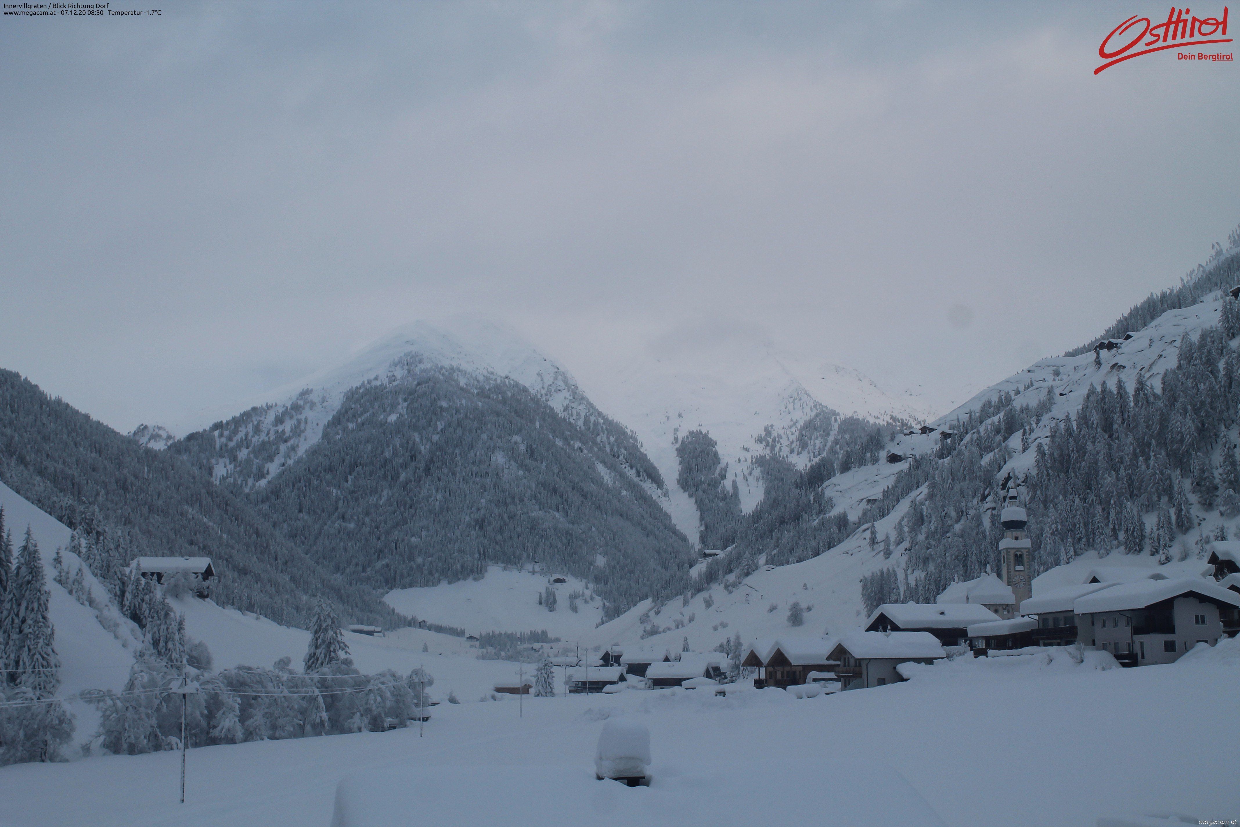
An example of a typical Südstau is the weather situation early December in 2020. A strong low-pressure area allowed polar air masses to penetrate far to the south. The strong and also very humid southern flow above Italy was able to hit the southern Alps, which resulted in excessive snowfall. It caused several snowfall records, precipitation amounts locally exceeding 200mm in 48 hours and a lot of nuisance in Osttirol and parts of the Dolomites.
")
 during the Südstau of Dec 2020 (wetterzentrale.de)")
You can see from the precipitation maps of 4, 5 and 6 December that first of all it was the French southern Alps which got a lot of snow. In the following days, the precipitation moved further east. On the 850 hPa (about 1500 metres altitude) temperature charts you can immediately see why it can sometimes be tricky with this snowfall, because the southerlies temporarily caused the snowline to rise considerably. It caused quite a bit of extra trouble: avalanche danger increased and we saw several large wet snow avalanches come down.