
We finally get to a situation where (large parts of) the Alps can receive a nice layer of snow. Don’t expect long-lasting mid-winter conditions, but Scandinavian blocking will allow the jet stream and thus the low pressure areas to follow a more southerly route. Over the coming week, the jet stream is regularly directed towards the Western Alps and then significantly more southwards towards the Mediterranean (see in the animation below), ensuring that the Southern Alps can possibly even expect a dump next week. The expected snow is likely to become the basis for the season above 2000-2300 metres, especially in the French Northern Alps and western Switzerland.
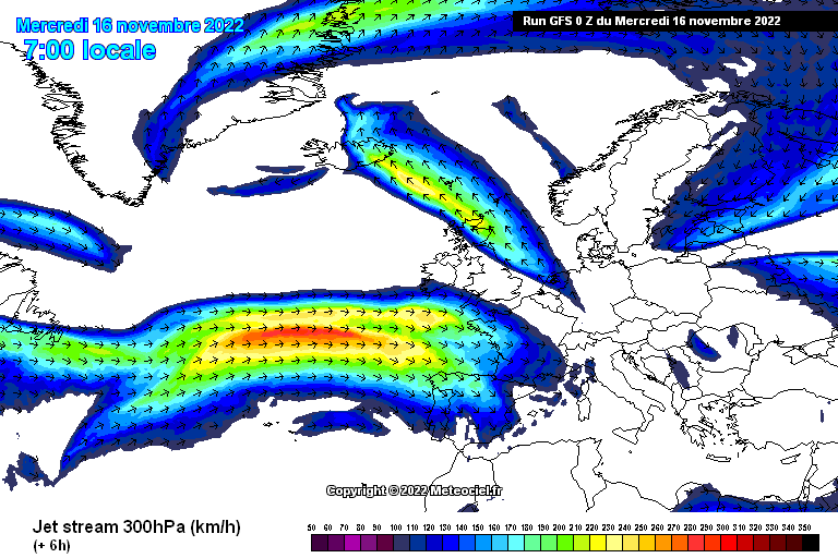 *An animation of the jet stream in the coming days (meteociel.fr)*
, as here in Lech (foto-webcam.eu)")
")
*An animation of the jet stream in the coming days (meteociel.fr)*
, as here in Lech (foto-webcam.eu)")
")
Today still fairly calm
Last night, a cold front passed over the Alps which left about 5 to 10 centimetres of snow, around the Mont Blanc massif up to 15 centimetres. During the cold front passage, winds picked up considerably higher up in the mountains. The precipitation front is now over the Eastern Alps, also giving several centimetres of snow above 2000 metres here. As seen on the webcams, it is already clearing up from the west.
Today, the Alps lie in a slightly milder western to southwestern flow in front of a small low pressure area. The passage of a weak warm front may cause some light precipitation during the night and tomorrow morning, first in the French Northern Alps and Wallis and then also on the northern edge of the Northern Alps, but this will not produce more than 1 to 5 centimetres above 2000 to 2300 metres.

Cold front with falling snowline
In the small warm sector of the low-pressure core over the English Channel, weak southföhn may develop in the northern Alps tomorrow, but the cold front is already approaching the northwestern Alps during the evening. The snowline drops to around 1300 to 1500 metres. I expect around 10 to 20 centimetres of snow from the Western Alps to Austria until Friday afternoon with possibly a bit more in the north-western stau areas in French Northern Alps and Western Switzerland. The southern Alps will mainly keep it dry, in the Dolomites it could be a few centimetres of snow above 1500 metres on Friday.
")
")
After the weekend a dump?
The weekend will be mainly dry with a chance of some showers in the northern Alps on Saturday. The really interesting developments will follow from Sunday afternoon. A new front approaches from the west, again bringing around 10 to 20 centimetres of snow in the north-western Alps. With the front, some colder air also flows in, possibly lowering the snowline to 1000-1200 metres.
On Monday, it looks like another hit: the Western Alps will once again get some snow, this time with significantly higher temperatures. The snowline could reach above 2000 metres. However, a separate low-pressure core over the Mediterranean could ensure that the southern side of the Alps also gets a lot of snow. This south side dump is not completely certain yet, but it looks promising. The US model is currently calculating the low pressure area too far to the south and has the core moving too quickly to the east. More on these developments on Friday!

Glaciers
All in all, the upcoming snowfall in the western and northwestern Alps ensures that conditions, especially higher up and on the glaciers, improve markedly. Part of the Grand Motte glacier in Tignes will therefore reopen on Friday.
Nevertheless, we still have to be careful. The snow cover is still very thin! The hot summer and intense glacier melt has caused many more glacier crevasses to be exposed, even higher up the glaciers, which is normally an accumulation area.