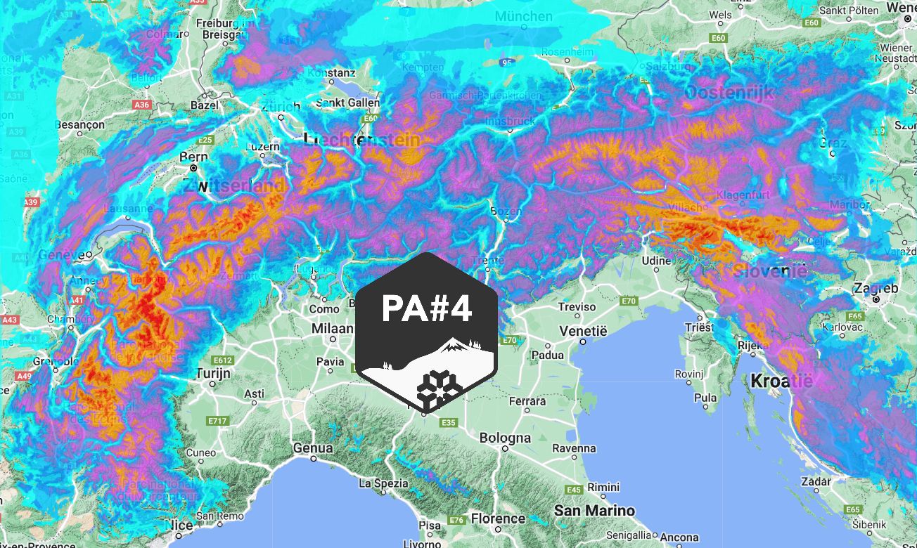
What a snow forecast map! The Alps are diving into a nice wintry phase that will last until at least the end of next week. In the coming days, we will see a substantial amount of snow on two sides of the Alps: (north) west and southeast!
In this weather report:
- A little warmer for a while
- Stormy days
- Snow bomb for Slovenia?
- Much more snow and wind on Monday and Tuesday
- Where to go?
")
")
Temporarily a bit warmer
Snow has been falling in the north-west Alps since this morning and later tonight and tonight on the north side. Some 5 to 15 centimetres will fall (most around the Arlberg) with a snowline dropping from 1,500 metres to 1,000 metres. Tomorrow it will remain dry almost everywhere. On the north side it will be a lot milder due to föhn.
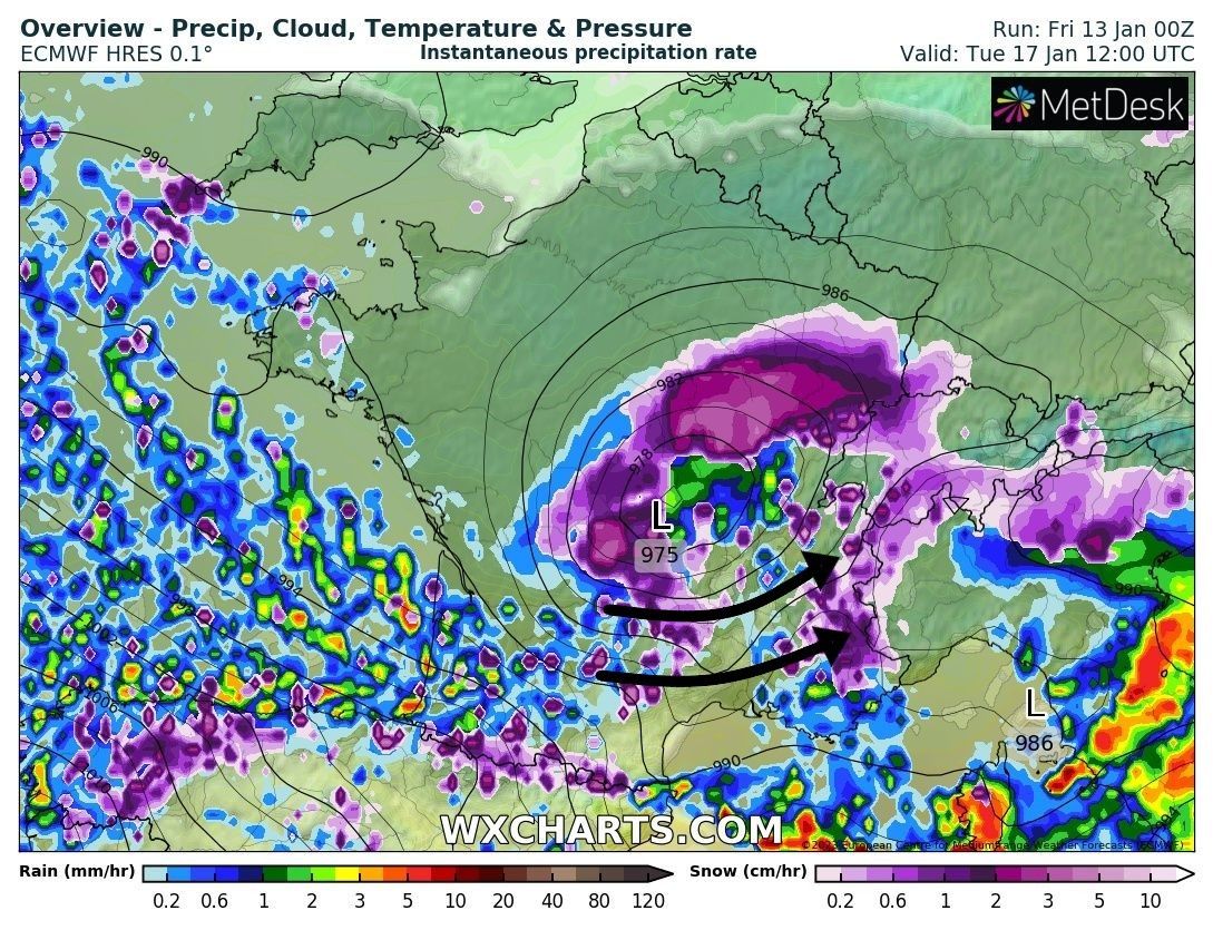
During the night from Saturday to Sunday, precipitation again approaches the north-west Alps. But before the cold front arrives, the northern and western Alps will first be in significantly warmer air. Initially, this precipitation here will therefore be accompanied by a fairly high snowline. The amounts remain limited, but it may therefore rain a little up to 2,000 metres for a while. Sunday morning, the cold front reaches the northwest Alps and the snowline drops below 1,000 metres during the snowfall. Some 15 to 30 centimetres of snow may fall. Most of it will fall in the north-western stau areas. The rest of Austria east of the Arlberg will get a bit less with a maximum of 10-15 centimetres. The Dolomites will also get a few centimetres Sunday night.
Stormy days
I should add that it will be quite stormy higher up. Tomorrow is not too bad, but with the cold front, the winds will pick up again. The north-western alpine edge and higher areas are already experiencing widespread problems with wind slabs. Yesterday it was already very windy here and so again this weekend. Therefore, read the avalanche bulletins in detail on what is possible and what is not in the coming days.
")
")
Snowbomb for Slovenia
In Slovenia, a brilliant setting for a short but fierce snowbomb suddenly develops during the night from Sunday to Monday. These areas (except Kanin) have hardly had any snow yet, but with the upcoming dump, other ski areas here too could therefore open (more) lifts. With perfect timing, moist air from the Adriatic could hit this corner of the Alps full on. From the north, colder air descends to the south. With this convergence of air masses, the moist flow from the Mediterranean should rise even more. Over Slovenia, the sponge is squeezed empty and locally more than half a metre of snow falls, with a low snowline. Areas in the eastern Carnic Alps and the rest of Carinthia may also benefit well with 20 to 30cm, but this is not entirely certain yet.
Monday and Tuesday much more snow (and wind)
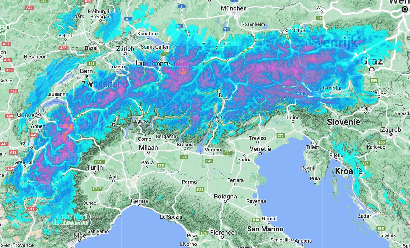
On Monday morning the intensity of the snowfall diminishes again in Slovenia, but new snow arrives in the Western Alps at the same time. It is cold enough that snow could fall into most valleys. Around 20 centimetres of snow could fall in the French Northern Alps. Also on Tuesday, a strong low pressure area directly west of the Alps will bring lots of snow in France and western Switzerland. Areas further east and the southern Alps also benefit somewhat. Once again, around 20 to 30 centimetres could fall in the hotspots of the French Northern Alps. Precise amounts still heavily depend on the route the low-pressure core follows. On top of that, there will be quite a storm on Monday and Tuesday, which will really make for tricky situations in combination with this fresh layer of snow!
During the night to Wednesday, this snowfall will also reach Austria, but probably in a weakened form. From Wednesday onwards, the cold is firmly in the saddle in the Alps and things seem to calm down a bit. The sun will get some more space and the wind will decrease again, but the exact details are really still uncertain. Snowfall could possibly set up again from the south. In any case, it remains wintry!
Where to go?
The base in the north-west Alps continues to improve. Note that lower down this is by no means the case everywhere, so the sweet spots will be at the higher treeruns where there is already a base and we therefore expect a lot of fresh snow again especially on Monday and Tuesday. Higher up, wind slabs are going to play a big role in the coming week. At least in the French Northern Alps, Monday and Tuesday will still be very turbulent. Therefore, stay low (but not too low) and far away from steep terrain on those days. The Southeast Alps are also a possibility, but with the exception of areas like Kanin and Nassfeld, many places here really still lack a base. If those 30 centimetres in the surrounding areas actually look like they’re going to fall, it’s not a bad option.
Read also:
Replies
Nice report! ;) Looking to fly in to GVA on the 21st. Best to head into France (where?) or to lower Wallis?
Nice report! ;) Looking to fly in to GVA on the 21st. Best to head into France (where?) or to lower Wallis?
Hi Henry,
I saw some news reports that the Pyrenees might also expect a lot of snow (up to a meter) coming week. What is your expectation for that region next week? https://cdn.wepowder.com/site/forum/15/c9d9e14dd98a57be5a701d380179a3d6_2d1ec883_611e_432e_b213_3e841adae67d.jpeg?width=800
Hopefully winter will last more than just one week.
What about Austria? I see most snow fall are on French alps, and Austria still has no powder and weak off piste
@@joosth I will include the massive snowfall in the Pyrenees in an update, thanks!
@@LiBTech1978 Austria has to be a bit more patient unfortunately, but there are some possibilities for more snow here in the second part of next week!
@@joosth I will include the massive snowfall in the Pyrenees in an update, thanks!
@@LiBTech1978 Austria has to be a bit more patient unfortunately, but there are some possibilities for more snow here in the second part of next week!Henri op 14 Jan 2023 19:27
Let’s hope not long waiting…
The Southeast Alps, including areas like Kanin and Nassfeld, could be an option, but many areas still lack a sufficient Wordle base. However, if significant snowfall occurs in surrounding areas, it could be worth considering.