We have had a turbulent Powder Alert #9 with lots of snow, a high snowline in the Western Alps and also lots of wind. The coming week will also remain very changeable, with some snow moments, but also wildly varying temperatures. Today, Föhn will provide spring conditions in the Northern Alps, while within 24 hours, a cold front could cool down again with quite some snow. Prolonged cold will not remain, which will make the search for powder a little trickier. Still, it’s time for a brief PA#10!
In this weather report:
- Recap of PA#9
- Föhn in the northern Alps
- Cold front brings cooling and snow
- Also snow in the southern Alps
- Brief PA#10
- Temperature yoyo with rising temperatures from Thursday
Short recap from PA#9
As we know, the boundary of cold and warm air masses was actually directly over the Northern Alps, which made determining the snowline in particular very tricky. Increasing temperatures on Saturday were in the models, with a sharply rising snowline, but eventually areas further north in the French Alps also had to deal with a very high snowline up to around 2,000 metres altitude, which logically made the snow very heavy up to high altitudes. Higher up, though, snow fell massively. In the French Northern Alps and Wallis about 80 to 120 centimetres.
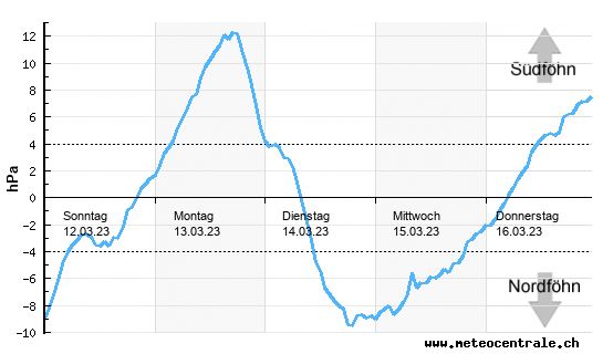
Föhn in the northern Alps
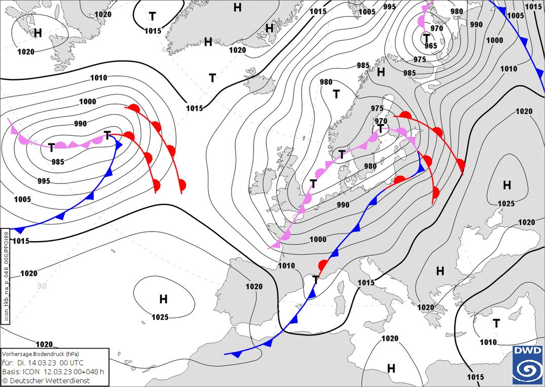
It was unfortunately not a prolonged cold spell, as a warm front has already brought in significantly warmer air. This morning, the Northern Alps still have to deal with the remnants of this front, but a strong depression is approaching from the Atlantic. Today, the core of this low-pressure area lies over Britain, with which Central Europe faces a south-westerly flow on the front of this depression. This brings in considerably milder air. At the same time, the pressure gradient over the Alps increases significantly, which will create southföhn in the Northern Alps. A short but intense episode.
Temperatures rise considerably at all altitudes. The freezing level rises to around 3,000 metres and in the valleys I expect spring-like values of around and just above 20 degrees. Here in Innsbruck, we woke up yesterday morning to a thin layer of snow, but today the 20 degrees could be touched here too. A greater contrast is hardly possible.
Cold front brings cooling and snow
Fortunately, this föhn phase is also short-lived, as another cold front with snow follows from the northwest during the night from Monday to Tuesday. The cold front passage is accompanied by falling temperatures, but it will not get really cold yet. Only on Tuesday during the day, the occlusion front behind it will reach the north-west Alps, bringing in considerably colder air.
Initially, the snowline is still just as high, around 2,000 metres, but with the cold front, I expect it to start snowing soon in the north-west Alps in areas above 1,500 metres. On Tuesday during the day, the snowline drops further. In the French Alps to around 1,200 metres, further east in Switzerland and Austria to around 1,000 metres. During the night into Wednesday, the snowline in the eastern north side will reach around 600 to 800 metres.
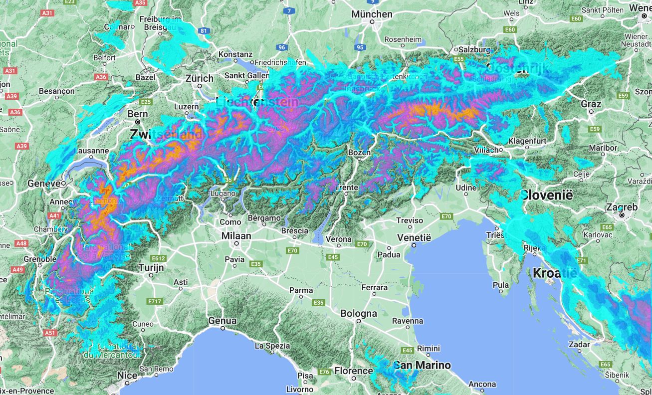
Also snow in the southern Alps
Snow is also in the forecast for the southern Alps this time. However, the snowline here will remain stuck at around 1,500 metres for an extended period. Lombardy and the Carnic & Julian Alps in particular seem to benefit the most.
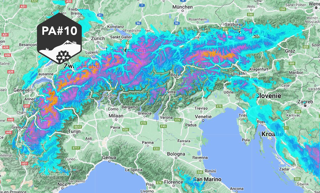
Brief PA#10
Surely, with this snowfall, it is time for a tenth Powder Alert. There are a few caveats to it though, as due to rising temperatures, this PA does have a limited lifetime. The centre of gravity is once again in the north-west Alps. Part of the initial snowfall falls with a fairly high snowline, so between 1,200 and 2,000 metres the amounts will obviously not be as large as in the high mountains, where it snows right from cold front passage.
-
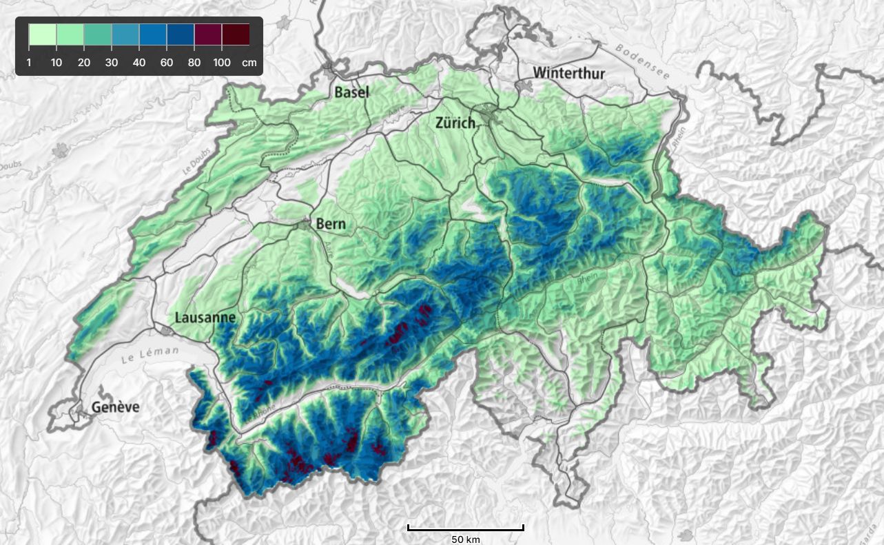
Northwest Alps
It is a strong cold front that passes, as in the French Northern Alps and western Switzerland I expect 20 to 40 centimetres of snow as early as Tuesday morning. The largest amounts are for Haute Savoie and western Valais. During Tuesday, snow will continue to fall due to the passage of the occlusion front behind it. The snowline starts to drop and through Wednesday morning the snow amounts are really substantial. From the Écrins to the Arlberg, about 40 to 50 centimetres of snow could fall higher up in the stau areas. From the Écrins to Valais, the amounts increase a little further. Around the Mont Blanc massif, accumulations of around 80 centimetres higher up are possible. -
Southern Alps
For the southern Alps, most of the precipitation will fall overnight through tomorrow during the day. In Lombardy and Engadine, amounts could reach around 30 to possibly 50 centimetres of snow. Tomorrow during the day, the snow will also spread further east and the Julian and Carnic Alps will also get quite some snow. 50 to 80 centimetres are possible here, with a metre possible in absolute stau areas such as the Kanin massif. The snowline here is initially very high, but drops to (just) below 1,500 metres on Tuesday afternoon and evening. The Dolomites may benefit considerably less from this snowfall. Here I expect around 10 to 20 centimetres. -
Austria
In Austria too, the cold front will provide snow, but (except for the Arlberg) significantly less than the Northwest Alps. Only on Tuesday evening, the snowline here drops further and it can continue to snow steadily, allowing us to see accumulations of around 20 to 30 centimetres in Tirol and the Salzburgerland on Wednesday afternoon. Around the Tauern, these amounts could also be significantly higher! -
Wind Particularly on Tuesday morning during the cold front passage, strong winds and large amounts of snow in a short time could of course cause lifts to delay or even not open. On Wednesday, the wind again decreases significantly.
-
Increasing temperatures
If you happen to be in the area, it is of course well worth it, but I must stress that due to the rising temperatures, this PA will really only be short-lived. Tuesday is a day for the French Northern Alps and western Switzerland. Here, a substantial layer has already fallen during the night and snow will continue steadily during the day with a falling snowline. Note that the snowline in the morning is not yet very low immediately. Wednesday will also improve further east. On the northern side, it will snow a bit more, especially in the morning, with a nice low snowline. From the west, it will clear up more and more. -
Don’t underestimate lawine danger
SLF currently reports:
The new snow and wind slabs of the last few days are lying on the unfavourable surface of an old snowpack in particular on shady slopes. Whumpfing sounds are a clear indication of a weakly bonded snowpack. Avalanches can be released by a single winter sport participant. In particular on west, north and east facing slopes they can penetrate even deep layers and reach large size. Isolated natural avalanches are possible. Backcountry touring calls for extensive experience in the assessment of avalanche danger and restraint.
With the expected snowfall as well as wind, new snow and wind slabs will of course remain a problem. Take this avalanche danger seriously and check the full avalanche bulletins including description before heading out.
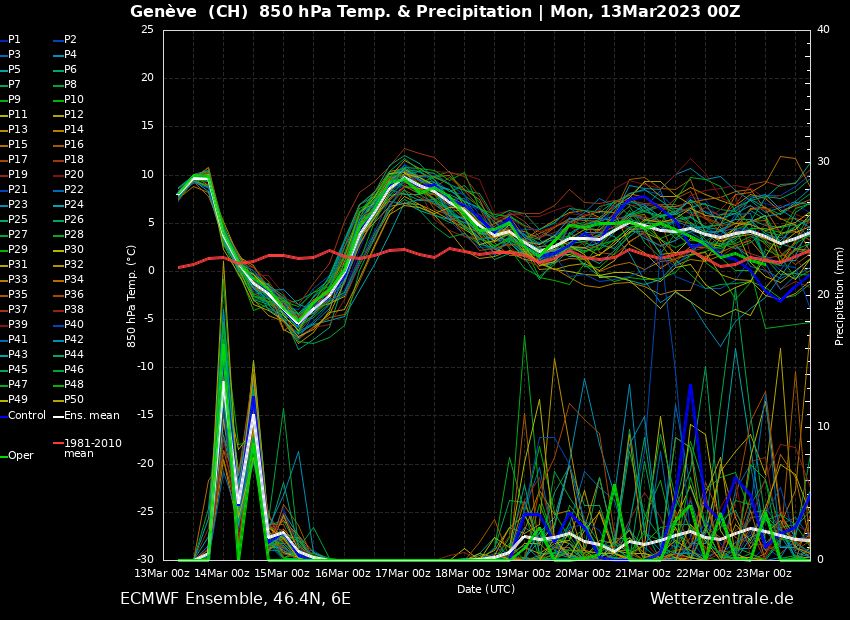
From Thursday warmer again
So, as mentioned above, even this cooling is unfortunately short-lived, as considerably warmer air moves in again from the west during the night from Wednesday to Thursday. Wednesday thus remains the only day when it will remain well cold. Due to föhn, temperatures of around 7 to 10 degrees at 1500 metres on the north and west sides on Thursday and especially on Friday could be very mild. It will remain dry until the weekend. After that, it is possible that it will become slightly more changeable again, but in the long term there is no serious March dump in sight for the time being.
Read also:
Replies
Thanks, sadly not for
Long pow will be available
Brilliant morning in Flaine today, knee deep super dry good stuff. It feels warmer than predicted already though. Thanks for the PA Henri!!!
French northern Alps were excellent yesterday. Thx for the PA Henri!
It was good in Austria