This week is all about lots of fresh snow for the Alps. Some is already falling in the north-west Alps and Austria today, but the real work will follow from Wednesday evening. For the eastern half of the Alps in particular, there could be quite a bit of snow on both the north and south sides. That means only one thing: PA#13!
In this weather report:
- First snowfall today
- Temporarily warmer tomorrow
- Tomorrow night cold front and lots of snow for north and south
- Where to go?
Already some snow today
The first snow already follows today with a cold front from the northwest. It won’t deliver large amounts yet, but in the north-west Alps, I still expect around 10 to 20 centimetres above 2000 metres in the stau areas. The snowline will drop to around 1,500 metres as the cold front passes. In doing so, the wind is quite strong today, especially in the areas close to the northern Alpine rim.
Tomorrow temporarily warmer with föhn
Before the second big phase of snow follows, it will get a bit warmer during the day tomorrow, especially on the northern side with a temporary south-föhn flow. This may also see some more sunshine. Temperatures in the valleys will rise above 15 degrees and it will also get significantly milder higher up. The freezing level will temporarily be around 2,500 metres. Throughout the north-west Alps, showers may already develop during the afternoon. The cold front with the real cooling will follow in the evening.
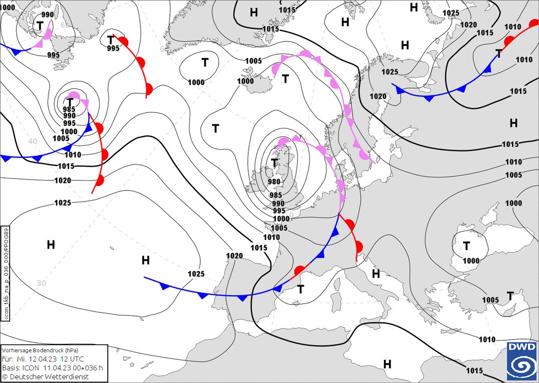
Tomorrow night follows the real deal
A new cold front will follow from the northwest tomorrow evening, bringing cooler air to the Alps. Over the Mediterranean Sea, a separate low-pressure core will form at the same time, which will ensure that snow will also start falling in the southern Alps, especially in the eastern part. This will also ensure that the precipitation on the northern side of the Alps will also be very strong in inneralpine regions. The moist southwesterly flow cannot descend due to the west to northwesterly winds in the lower parts (the inflowing cold air) and thus continues to rise north of the alpine main ridge. These upward movements can cause a lot of precipitation to start falling, and the cold air also causes the snowline to be very low, especially in the northern Alps. A typical example of a Gegenstromlage, something I briefly explained in this article.
Initially, though, it is still quite mild. The snowline is above 1,500 metres at first, but drops more and more during the evening. In the second half of the night, it may even snow below 1,000 metres. Until Saturday, I expect the snowline in Austria to hover between 800 and 1,200 metres. On the south side it will be a bit warmer on Thursday and the snowline will be around 1500 metres, but here too it will cool down a bit and the snowline could drop several hundred metres.
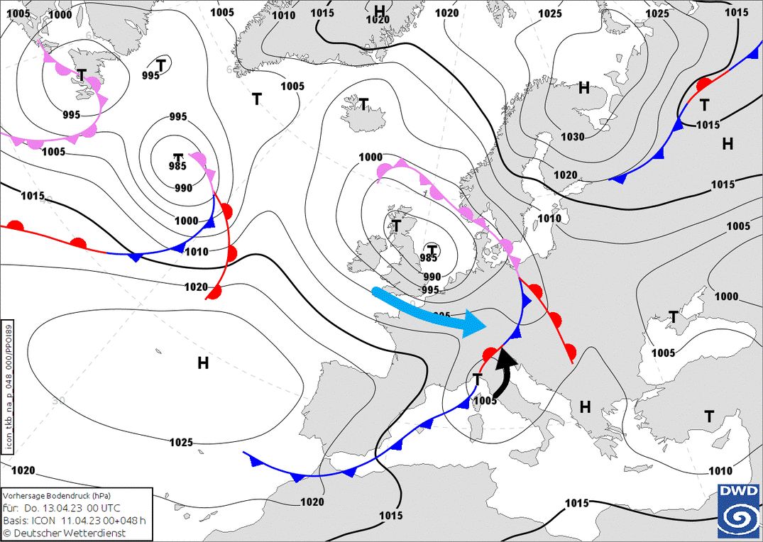
The core of this low pressure area then moves further east towards Croatia on Thursday. While it will become drier in the Western Alps, it will continue snowing in the Eastern Alps for a long time, possibly into the night from Friday to Saturday. Winds pick up considerably during the front passage Wednesday evening and night. In the southern Alps, strong north-föhn will cause strong winds, especially on Thursday (in the western part) and more to the east on Friday. Areas such as the Tauern will also be affected.
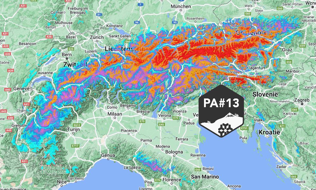
Half a metre on a large scale
All in all, quite a bit of snow could start falling. First, with the front passing from Wednesday to Thursday in the north-west Alps about 20 to 30 centimetres through Thursday morning. Then Thursday during the day it will snow solidly in the Eastern Alps (north and south side). Here I expect around half a metre of snow on a large scale higher up until Friday morning. I expect the largest accumulations around the Tauern, from the Zillertal Alps to western Styria. Here, amounts could reach up to a metre! Also further south in Carinthia, the Dolomites and the Carnic & Julian Alps, half a metre could fall on a large scale with peaks of up to a metre.
For Friday, developments are still somewhat uncertain. In eastern Switzerland, Vorarlberg, Tyrol and on the southern side, among others, it may clear up a bit in more and more places. In the eastern regions of Austria, it could snow for longer. New snow may also follow for the north-west Alps, but here the weather models really don’t agree yet.
Where to go?
If you want to hit the powder on Thursday, then the areas in the north-west Alps are not a bad choice (e.g. Vorarlberg), here quite a bit of snow has already fallen during the night and it will continue to snow a bit during the day. Further east is of course also an option. You’ll be in the middle of the strong snowfall, with the most of it is falling during the day, so it’s getting deep fast.
On Friday, most of the snow has now fallen, also in the eastern areas, but the wind is going to play a bigger role with a lot of wind higher up in the southern Alps and the eastern inner-alpine areas. Since the snowline is quite low, there is no need to get too high yet. Higher treeruns in Tyrol, Salzburgerland and on the southern side will still be doable. Do note that the base is lacking on southern slopes up to quite high and in lower elevations on all directions. It is mid-April.
Read also:
Replies
Murphy’s law, as most of the resorts closed operations last weekend in the Eastern region
Ik volg!
Was looking into heading into Hinterlux and Tux area, anyone recommend it for some offpiste in this deep stuff, or recommend something else in the area?
Is somebody in Zauchensee on Firday I am searching for someone to ski with
Will be at Kitzsteinhorn on Sunday and probably Monday 1/2 day. Anyone there to ski with?
Is somebody in Zauchensee on Firday I am searching for someone to ski with \
Maxirock op 12 Apr 2023 17:14
I was there with my daughter on thursday and friday… a pity I did not look at the english forum, I only look at the dutch forum…
W https://cdn.wepowder.com/site/forum/15/b74a492b223bd09c6df728b729f8f2cf_20230416_150135.jpg?width=800\
Was good at higher up in glaciers like Saas Fee